
Salem is a city of extremities in terms of its physical shape: two “necks” jut out into the Atlantic Ocean from a central peninsula. You can easily see that this was a settlement oriented towards the water rather than the land. Once transportation shifted towards the latter, traffic problems emerged for Salem, and they still present a major challenge to the city. One interesting Salem neighborhood which seems to represent the shifting impact of transportation very well is Bridge Street Neck, the first area to be settled by Europeans and the main gateway to the north. Its central corridor or “spine”, Bridge Street, first led to a ferry, and by the end of the eighteenth century the first bridge to Beverly was completed. From that time the area developed in typical mixed-use fashion, with commercial structures and residences rising up on Bridge Street, smaller houses on the side streets leading down to the water on both sides, and manufacturing sites interspersed: first maritime-related uses, later lead and gas works. There are all sorts of references (though I can never find images) to horticultural uses as well, from the first fields of the early “old Planters” to nineteenth-century greenhouses and pleasure gardens to today’s parks. In a few months Salem’s newest park will open at the very end of the Neck, dedicated to the work and memory of the Abolitionist Remond family.

 The North Shore coastline from Edwin Rowe Snow’s The Romance of Boston Bay, 1970; 1903 Map of Salem and surrounding places, Henry M. Meek Publishing Co., Leventhal Map Library, Boston Public Library.
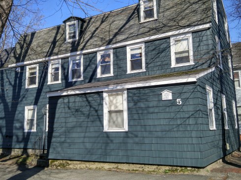
Carriages, trains, trolleys, CARS: for too long Bridge Street Neck has simply been a place to get through.It’s never been a destination, unlike Salem’s other neck, home to the Willows. But over the past decade, a series of infrastructural changes have (perhaps) transformed this Neck’s functional status: a new bridge attached to a new bypass road which skirts the neighborhood rather than running through it, and a “revitalization plan” implemented by the city to address its aesthetic and economic challenges. I think this is a Salem neighborhood that is really primed for change, but in what direction? Its diverse building inventory–ranging from late eighteenth-century Georgians to post-war Capes–is protected by the recent designation as a National Register Historic District but not the more stringent review of a local historic district. And there is much to protect: there are some great old houses interspersed among the streets of Bridge Street Neck, better appreciated if you get out of your car and walk.


LOVE this Gothic Revival cottage and its mansard-roofed neighbors on Arbella Street, named for the ship that brought John Winthrop to Salem in 1630.


Very pretty Victorian two-family; two early nineteenth-century houses: a Georgian (behind the addition) and the stunning c. 1805 Thaddeus Gwinn House, an unusual Salem two-story Federal (today and in the 1980s, courtesy MACRIS); two cute cottages on the North River side of Bridge Street.


The old and the new on Bridge Street including the Thomas Woodbridge House on the corner of March, and across from it: the future?


April 26th, 2016 at 11:47 am
I think that middle house on Arabella Street is Stacia Kraft’s old house, no?
April 26th, 2016 at 11:50 am
I believe it is! Really great condition–that’s a nice street.
May 3rd, 2016 at 7:47 pm
Not that you haven’t done so before, but this piece is a good reminder to get away from the tourist sites if you want to see the community as a whole.