I remain obsessed with colonial taverns, an obsession that stems from 1) the fact that Salem has several establishments called “taverns” which are not really taverns; 2) the loss of one spectacular tavern and “denaturing” of another on one of Salem’s most venerable and now saddest streets, and 3) my desire to learn how to create digital historical maps. I searched through this unwieldy blog of mine (which needs an index) and see that I’ve posted on taverns several times before, but here I go again. This particular post was prompted by a walk down Boston Street, once and still a major entryway into Salem, with many historic structures still standing—though much altered as “spotty” zoning has long been the rule. I don’t think that this street has been paved for decades, so it’s sort of a minefield if you’re in a car, so walking is preferable. Last week’s obsession was cemeteries, and so I wanted to see an old cemetery that is situated on the Salem-Peabody line on Boston Street: the Old South Cemetery, in which many members of the Trask family of Salem are buried as they owned considerable land in this area. As soon as I saw them all lined up in the cemetery, I thought of the “ancient” Trask family homestead which was once nearby, which for many years operated as the Black Horse Tavern, and on my walk back I passed by a much altered building which once served as the tavern of Daniel Frye: its McIntire interior woodwork and Zuber wallpaper was stripped out in the 1920s and sold to the Saint Louis Museum of Art, and now it is tattoo parlor with a fake palm in front, right next to a new housing development distinguished by a mishmash of architectural styles and liberal use of plastic.


 Boston Street in the 1890s from the Frank Cousins Collection of Glass Plate Negatives as the Phillips Library, via Digital Commonwealth; the Trask Homestead/Black Horse Tavern on Boston Street—exterior and interior—in 1901, New England Historical and Genealogical Register Volume 55; the Symonds Chest which was once in the front parlor of the Trask homestead/Black Horse Tavern, Yale Digital Collections; 94-95 Boston Street, once Frye’s Tavern, now partly a tattoo parlor.
I’ve been working intermittently on a series of digital maps which can present Salem’s colonial history in a visual format and contain a lot of information in this blog: the end goal would be one map with many layers like this great prototype here. The work is slow as I’m on a steep learning curve with the software, and there is also a lot of content to uncover: so far I have working maps on Salem churches, houses where enslaved people resided, and taverns. The first topic is easy enough to research, but I need a lot more information to present the extent of slavery and hospitality in a substantive manner. There were a lot of taverns in colonial and early-19th century Salem, both licensed and unlicensed—and I don’t think I’ll ever be able to locate all of the latter! Despite the warning of the pastor of the First Church that “drunkards are excluded from the kingdom of heaven”, the number of taverns in Salem appears to have increased steadily over the century from 1670 to 1775, with many anecdotal complaints against their “excessive number” in the town records. According to Sharon Salinger’s Taverns and Drinking in Early America, “as a whole, Essex County averaged one tavern for every 219 people….[but] Salem town averaged one tavern for every 80 persons, a slightly higher proportion of drinking houses than the larger ports.” I’ve still got quite a bit of work to do to find all those taverns, but this is my working map:


It took me quite a while to figure out all the various “Ship” taverns and the myriad tavern names attached to the buildings I have labeled “Essex Place” in my key; I’ve got a lot of tavern-owner names, but not all the locations. Some of the descriptions fuel my obsession: the famous Sun Tavern is described as “rough cast”, or covered in rough plaster in which pebbles and glass shards were embedded in ornamental patterns, and I would love to find an image of the “Great Tavern with many peaks” which was said to resemble the Bradstreet House on Essex Street, itself transformed briefly into the Globe Tavern. Because I can’t find my perfectly-preserved tavern in Salem, I often look for them on road trips. Yesterday I drove west along part of the closest approximation of the old upper “Boston Post Road” between New York and Boston: routes 20, 9, 67, and 20 again from Waltham to Springfield. Along certain stretches of this route–the non-urban and suburban ones—you really feel as if you are on the old Post Road, a feeling that is intensified by the eighteenth-century mile markers along the way. I was looking for taverns but got a bit distracted by the markers: you would expect both to be in clear view but I was looking with 21st century eyes and often they were a bit “hidden” or off the beaten path. But that just makes the journey more alluring.


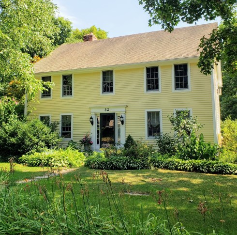


Taverns and markers along the old Boston Post Road in central Massachusetts: the Golden Ball in Weston, Wayside Inn in Sudbury (easy to find!), Pease Tavern in Shrewsbury (and in a c. 1900 photograph by Harriette Merrifield Forbes at the American Antiquarian Society), where the markers were very easy to find, markers in Leicester, East Brookfield and West Brookfield, where “Ye Olde Tavern” is still very much alive and open. There was also a beautiful house for sale right at the head of West Brookfield common, which fulfills all my tavern fantasies–there’s even a ready-made post for the sign.


 An abandoned farmhouse on Old Dana Road, and the Quabbin Reservoir.


