Tag Archives: urban planning

Searching for Castle Hill

When I do not walk to work down Lafayette Street, I drive down Jefferson Avenue through a neighborhood called Castle Hill, which has neither a castle or a hill. I’m not sure it ever had a castle–nineteenth-century antiquarians assert that the great Nanapashemet, majestic leader of the Pawtucket confederation of tribes before the arrival of the Old Planters, maintained some sort of “castle” in this area, but I don’t know if this can ever be verified or if it is the source of the place-name. Much later, this land was owned by the (almost) equally royal Derby family of Salem, who maintained a vast farm to sustain and complement their city properties.The great diarist (and gossip) the Reverend William Bentley tells us about a walk in early June of 1809 in which he passed to Castle Hill upon which Mr. E. H. Derby has erected a small summer house of two small square stories, the upper of smaller dimensions, in the Italian style. It wants the grandeur of the former house which occupied this space [was this the castle? It didn’t last long in any case–destroyed in the “Great September Gale” of 1815]. He has shut up the old road by Forest river road & opened a new road, over a New Bridge finished last year, leading to the Mansion House upon the road to Marblehead. The Garden is extensive and well arranged, without any unnatural or useless ornaments. The old Farm House at the foot of Castle Hill is in a state of decay. At this season the hill & fields are alive…….So castle or not, there was certainly a hill, surrounded by Derby farmland and pastures, including the “Great Pasture”, bounded by Mill Pond, over which one could look north to Salem the town, almost a separate town altogether. This perspective is illustrated by two great steroeviews from the 1870s and 1880s, both taken from Castle Hill.

Castle Hill Collage

Castle Hill Farms

Stereoviews by Moulton and Fogg from the 1870s and 1880s; paintings of Pickman and Derby farms (Corné) from the early 19th century; Northeast Auctions and Historic New England.

Castle Hill is referred alternatively to the “Great Pasture” or the “Salem Pastures” all the way up to the turn of the twentieth century (and even after) but changes are coming, ushered in by the Boston and Maine Railroad, the filling-in of Mill Pond, and the leveling of the hill by the Massachusetts Broken Stone Company, which also maintained a quarry in this pastoral realm for a while. In his 1894 article entitled “Some Localities around Salem” Henry Mason Brooks of the Essex Institute opined that I dislike to see these old localities disappear, but change will come and we must make the best of it. If you compare the Salem Atlases of 1874, 1897, and 1911 you do see a changing landscape and streetscape in Castle Hill, as members of the growing French Canadian population of Salem moved into the area with the foundation of Sainte-Anne Parish in 1901: this church, which burned down in 1982 and was rebuilt over the next few years, remains the center of Castle Hill. A decade later, the 1912 annual report of Salem’s first planning commission identified Castle Hill as the future of Salem: The great area comprising the Salem Pastures may be made into splendid home sites with magnificent views, and winding roads with good grade can readily be built when the proper time comes. It is here that Salem must develop if it is to have the future which we believe its traditions justify, and the business demands. Much more housing did indeed follow, but large parts of the pasture and woodland were preserved later in the form of Highland Park/ Salem Woods and Olde Salem Greens. And if you drive off Jefferson Avenue just a few feet, you can see the rocky remains of the hill anywhere and everywhere.

Castle Hill Map 1897

Castle Hill 4

Castle Hill 1

Castle Hill 3

Castle Hill 5


Londonopolis

I have returned from my whirlwind tour of London, which is itself a whirlwind, continuing and even intensifying the dynamic expansion (up and out) that I witnessed the last time I was over there, with no cessation in sight! There’s nothing new about this: the metropolis (Londinopolis, according to the title of James Howell’s 1647 survey Londinopolis an historicall discourse or perlustration of the city of London, the imperial chamber, and chief emporium of Great Britain: whereunto is added another of the city of Westminster, with the courts of justice, antiquities, and new buildings thereunto belonging) emerged in the later sixteenth century and just kept growing all the way up to the twentieth century, when wars stopped and then resuscitated its regular redevelopment. London remains the “chief emporium” of Great Britain, but also of the world. It was difficult to take a picture anywhere in the city without capturing a crane in the background: construction zones abound in every district. And even where there are no cranes there are constant contrasts between old and new–some quite shocking–and some more subtle. But London remains an amalgamation of neighborhoods, and I do wonder what its citizens think of the relentless development pressure. You hear complaints of “blackened” Belgravia, where wealthy foreigners have purchased flats in which they will never live, and “iceberg houses” with hugely built-out basements below ground, but what looks like folly architecture to me seems okay to Londoners. I purchased a book by Rowan Moore, the architecture critic for the Observer, to give some insights into London’s 21st-century building boom during the long flight home, but Slow Burn City was more about anecdotal building than perceptions of planning, for the most part.

I did complete my planned itinerary (including Botticelli Reimagined at the Victoria & Albert, which was ok, but from my perspective presented in backwards order; the Pepys exhibition at the National Maritime Museum, which adhered to its one man’s life and times format without fail, and the AMAZING sixteenth-century Sutton House in Hackney, which will get its own post), and took students to Hampton Court, Westminster, Greenwich, and the Tower of London. The rest of the time I spent in the east end–in Spitalfields and Shoreditch– exploring bustling neighborhoods that I didn’t know very well, inspired by the wonderful blog Spitalfields Life and steadfastly avoiding the Salem-like Jack the Ripper Museum, which was supposed to be about the lives of the female victims (and working-class women in general) but is somehow not. Spitalfields is surrounded by modern buildings but its core is eighteenth-century, and it has been a long-time refuge for immigrants: French Huguenots in the seventeenth and eighteenth centuries, Irish and Jews in the nineteenth, and Bangladeshi today. It is home to the Old Spitalfields Market, which is probably the best market in London, a city of great markets. I fell hard for an architect there, and I don’t mean my husband (who came along): one sight of Nicholas Hawksmoor’s Christ Church, Spitalfields and I was a goner–so he’s going to get his own post too.

Some of my favorite places and photographs: more focused posts to follow all week.

London Staple Inn

London Staple

London Liberty

London Busts

Real Tudor and Faux Tudor: Two of my favorite buildings in London: the Staple Inn in Holborn and Liberty of London; busts from Liberty, the National Maritime Museum in Greenwich, and the Victoria & Albert Museum.

London Trooping

London Tower View

London 483

London Tower

London Graffiti Collage

London V and A courtyard

London Greenwich.jpg

Troops trooping near Buckingham Palace; In the Tower yard; armour in the White Tower; “graffiti” on window frames in the Tower and at Hampton Court Palace; The view from the White Tower–fortress against modernity! In the garden at the Victoria & Albert; the view south across the Thames from the Royal Observatory, Greenwich.

London St Pancras

Pancras todayLondon Marleybone 2

London Marylebone

London Placques

The amazing St Pancras train station and adjoining hotel, saved from demolition by Poet Laureate John Betjeman, whose statue is prominently situated inside; Marylebone streets; a few blue placques.

London 455

London Spitalfields

London bags Spitalfields

IMG_20160313_215701[1]

IMG_20160320_155918[1].jpg

London Fournier

Very Vibrant Spitalfields: Nicholas Hawksmoor’s STUNNING Christ Church, Spitalfields (completed 1729) with which I am OBSESSED; the view from the Church: old and new buildings encasing the market; a few items from the market (thanks Carol!), the beautiful Fournier Street; an effigy of London Mayor Boris Johnson (or Donald Trump)?


Ever in Transition

The tensions between public and private interests, commercial and residential concerns, and historic preservation and economic growth are nothing new to Salem, which has always been a dynamic city proud of its past and poised for the future. Some eras are more dynamic than others, however, and I think we’re in a particularly dynamic period now, but any city or town or settlement is always in transition, of course. When I hunt for historic photographs I’m always on the lookout for the mix of “ancient” and “modern”, residential and industrial, small-scale and larger, dirt roads and railroad tracks. My very favorite visual chronicler of Salem, Frank Cousins, who was himself living through a very dynamic age, was clearly attracted to that mix as well, as one of the photographs that he submitted as part of Salem’s exhibition at the 1893 Columbian Exposition was that of a divided Derby Street doorway labelled “modern” and “colonial” (A subtle distinction for our modern eyes).

In Transition Cousins 1892 Columbian Exposition

Frank Cousins photograph of a Derby Street doorway, c. 1892, courtesy of Duke University’s digital Urban Landscape collection.

More illustrative of the city in transition, as opposed to a co-joined household, are the many pictures of Town House Square that date from the 1880s to about 1910. There you see predominantly brick multi-story commercial buildings, but if you look closer, there are still some surviving wooden residential structures (although they are probably serving a multitude of uses). For several years, I have had in my possession a stereoview of a building labeled “Ward-Goldthwaite & Co. Salem” which I thought might be one of these structures, only to realize that I had made a rookie historian’s mistake (not questioning a label): the Ward-Goldthwaite Company was located in Chicago, not Salem (even though it was published by the Moulton firm of Salem). Nevertheless, it’s a great image of a city in transition: you know that house isn’t going to last long.

In Transition Cousins Town House Square 1892 LOC

In Transition 1906 LOC

Stereoview Ward Golthwaite Co Salem

Town House Square at the intersection of Essex and Washington Streets, Salem, (Library of Congress) and a stereoview of the Ward Goldthwaite & Company in Chicago published by J.W. and J.S. Moulton of Salem as part of their “American Views” series.

The idea of zoning starts to catch on in Salem after 1900, and it was definitely accelerated by the Great Salem Fire of 1914. But before this momentous event, factories and residences co-existed in close proximity in the Point, Blubber Hollow and even the more residential North Salem, where the large Locke Regulator Company bordered the North River and a line of colonial houses on North Street. Some of the houses are still there, serving mixed uses as they did a century ago, while the Locke factory has been replaced by a junkyard and a car wash. The streets along Salem Harbor have always been among the most densely settled in Salem, but the 1903 photograph seems to show structures which are primarily residential–I’m not sure of the precise vantage point, but I’m assuming these buildings were all swept away by the Fire. The last photograph, from the PEM’s Phillips Library, shows fire bystanders watching the conflagration on Lafayette Street from the roof of a building on Highland Avenue: a view of mixed-used zoning with the new High School, the factory, and residences all in close proximity to one another. Highland Avenue became a preferred location for commercial development over the twentieth century, but as this photograph indicates, residences were built along it as well–and a few older structures, drastically transformed–still stand among the big box stores.

In Transition North Bridge 1890s

Salem 1903 Locomotive's Journal

phillipslibrarycollections.pem.org

Looking north along North Street from the old bridge, 1890s, Boston Public Library; A Perspective on Salem Harbor, 1903, Brotherhood of Locomotive Engineers Monthly Journal, September 1903; Watching the Great Salem Fire from Highland Avenue, 1914, Phillips Library, Peabody Essex Museum


A Bigger Picture for Bridge Street

I have been watching and listening to the public hearings over the proposed redevelopment of the former Universal Steel and Trading Corporation site on Bridge Street with great interest and concern. The site is located adjacent to a distinctive late nineteenth-century factory building owned by the F.W. Webb Company, a large distributor of plumbing supplies, which seeks to abandon this same building and build a new (far less distinctive) showroom and sales facility next door. Objections to the proposed building could be based on its rendering alone–it’s the typical glass and faux-brick generic building that we’re seeing everywhere and anywhere–but there are several other key factors which make this project troubling and controversial. The site is also located adjacent to the northern boundaries of the McIntire Historic District, in close proximity to the well-preserved colonial and Federal houses of Federal and River Streets. The owners of these houses do not want a large commercial building (the actual elevation of the proposed structure is a matter of debate) casting a shadow over their streets, and the intensity of their opposition has been fueled by the fact that they believed that the long planning process resulting in the creation of the “North River Canal Corridor” a decade ago ensured that more creative uses for this area would be pursued. The second factor is the contamination of the site and the costs and consequences of cleaning it up. The property was transferred to the city of Salem after Universal Steel ceased operations, and the city requested aid from both the EPA and the Massachusetts DEP to conduct a partial clean-up, which involved the removal of over 4,000 tons of contaminated soil. After this process, the city paved over the site to create a temporary parking lot while the new MBTA garage was being built. Once that project was completed the city sought a more profitable use for this parcel–and F.W. Webb put forward the only proposal. The new construction will require a more comprehensive clean-up, and the costs and potential health threats of such an invasive process are a matter of concern to everybody, but especially those in the adjacent neighborhood. A third major factor is the transfer of an “ancient way” from public ownership and use to Webb: Beckford Way, in existence from the seventeenth century, which will be transformed from public pedestrian path to private truck access and loading dock. Opponents of the Webb proposal ask (quite logically I think): if the Company is going to abandon its present building altogether, why doesn’t it relocate to a section of Salem that is dedicated exclusively to commercial uses and leave our neighborhood–and our way–intact?

Big Picture Bridge Street

UniversalSteelTradingCorpSite EPA

Bridge Street Salem January

Beckford Way

Aerial view of the site of the proposed new F.W. Webb building, marked by the X; the initial clean-up in 2012, with River Street houses in the background, EPA; these same houses last month (before our recent snow) looking over the temporary parking lot and reflected in the North River; Beckford Way.

You can read a more detailed summary of the project here, and also peruse project documents. The narrative presents a decidedly pro perspective, but you can easily discern the debate in the FAQ section. We’re in the midst of the process: already the City Council has held two public hearings on the project and there are more to come. As I intimated above, I’m very sympathetic to the concerns of my McIntire District neighbors (and believe the present Webb building would make fabulous housing given its proximity to the train station) but am also striving to widen–or elevate–my perspective, inspired by both a phrase I heard repeatedly at the first public meeting—“spot zoning”—as well as one of the more thoughtful observations of the night, expressed by an earnest River Street resident: Salem’s fabulous history and outstanding architecture is constantly at risk from unsound planning. These words resonated with me immediately as I feel that way all the time: our city’s piecemeal planning has led to undistinguished architecture, unlimited accommodations, and unceasing divisiveness, and it will continue to do so until we can all look at a bigger picture. Salem is hardly the only historic city facing myriad redevelopment challenges and opportunities at the moment: why can’t have a more comprehensive and proactive plan rather just reacting, reacting, reacting? Look at the example of our neighboring seaport to the north, Portsmouth, NH, which is pursuing “character-based zoning” (which must surely be the antithesis of “spot zoning”) by plotting out its development goals and proposals in “textured” 3D models that are available to the public on a web portal, so that everyone can see what proposed buildings will look like, in context and as part of a whole. We don’t even seem to know the actual height of the proposed Webb building on Bridge Street, much less how it will look in relation to its neighboring buildings (but I’m thinking, not good).

3DPortsmouthLead_920_557

3DPortsmouth1

Webb building

Plan Portsmouth 3D Model/Developed by Tangram 3DS;  our only view of the proposed Webb building.

Losing our Way?

One of the latest looming commercial developments in Salem is a proposal for a new showroom facility by the F.W. Webb Company, a large distributor of plumbing and HVAC parts, on an abandoned lot adjacent to its large brick building on Bridge Street. The lot was long occupied by the Universal Steel and Trading Company, which stored and processed scrap metal on the site, creating a contaminated cauldron from which they simply walked away, leaving the City to clean up the mess. Once the site was cleaned up–a process that took several years–the City put the parcel up for sale, and F.W. Webb was the only bidder. The public process by which the City divests itself of the site and the Webb proposal is reviewed by various city boards commenced last week, and consequently both the big picture and the little details are starting to emerge. Regarding the former, the jury’s still out for me–of course the proposed new building appears blandly “modern” and appears to have no connection to the existing Webb building–but this section of Bridge Street is not distinguished by structures of great architectural integrity. Where the terraced gardens of Federal Street houses once sloped down to the North River used car lots have more recently and characteristically occupied a filled-in Bridge Street, so you can argue that anything is an improvement. There are two “details” that do concern me at this point in the process, however: 1) the not-so-veiled threat inherent in the F.W. Webb proposal documents: this new building will allow us to remain in Salem and; 2) the loss of venerable public “way”called Beckford Way. This public path once accessed the riverfront but is now a trail to nowhere; nevertheless, it is still public property and will cease to be if the Webb proposal is approved.

Path 009

Webb Building

Path 001

Beckford Way

Bridge Street 2016 MA Boating and Fishing Access

NOW: The current Webb building on Bridge Street and the adjacent lot, now cleaned and paved, on which the company wants to build a new showroom building; rendering of the proposed new building and Beckford Way alongside the lot. A current map of Salem, with no Beckford Way.

I looked into the history of Salem’s public ways a bit, primarily by examining maps of the city in 1820, 1851, 1903 and 1916 in the Norman B. Leventhal collection at the Boston Public Library. It was an interesting exercise, through which you could clearly see the disappearance and/or transformation of myriad ways, courts, and even streets by projects that were both public and private. The nineteenth century privileged the train while the twentieth century was all about the car; the pedestrian lacked advocacy in both centuries. Sewall Street, once lined with houses, became a parking lot for the YMCA and adjacent developments; Liberty Street was absorbed by the Peabody Essex Museum just a decade ago. Now all of Salem’s “ways” exist only in condominium developments built out on Highland Avenue: they’re not even really part of the city.

Salem 1820 BPL

Bridge Street Before LC HABS

THEN: Jonathan Saunders map of Salem, 1820, clearly indicating Beckford Street’s access to the North River, Boston Public Library Leventhal Map Center; a map of the terraced gardens of Federal Street (a bit further west from the Webb property) before the River was filled in for the railroad and Bridge Street extension, HABS, Library of Congress.


Salem Spirits

After the various map posts, which go viral immediately and retain a steady following thereafter, the most popular posts on my blog have been those focused on spirits, in particular an examination of a peculiar Salem drink from colonial days named Whistle Belly Vengeance and the story of a libelous temperance pamphlet directed at the wealthy rum distiller who happened to build my house. I can understand why: there’s just something very alluring about alcohol! The process of distillation, in particular, has always had a rather mysterious and even diabolical reputation, from the days of alchemy to that of Nathaniel Hawthorne, when a certain ambitious temperance minister named George Cheever targeted the largest rum distiller in town, John Stone (who built my house and styled himself Deacon for his role at the First Church of Salem) in an allegorical pamphlet entitled  The Dream, or, The True History of Deacon Giles’ Distillery (1835). In the thinly-veiled Deacon Giles, who concocted barrels of cholera, murder, fever and delirium with the aid of his demon workers, Deacon Stone saw the inverse of his pious self: both men were (hypocritical) bible-society members, both lost relatives in the diabolical vats of their distilleries, both had alcoholic sons, both made demon rum. Stone sued for libel and won, but Cheever became a cause celebre and temperance hero during the trial. His little story was reprinted for a national audience, and within the next decade Stone’s largest distillery was converted into a sawmill.

Deacon Giles Frontspiece 1835

Domestic and Demonic Distillation: Rebecca Tallamy’s Book of Receipts. Written in the margins and blank spaces of a copy of John French’s Art of Distillation, 1651, Wellcome Library, London; the frontspiece to George Cheever’s True History of Deacon Giles’ Distillery, 1835, New York Public Library Digital Gallery.

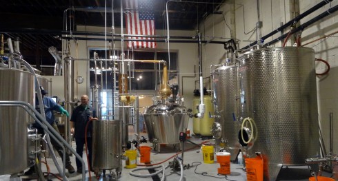
But now Deacon Giles, and rum distillation, has returned to Salem in the form of a new (and real) craft distillery named after the fictional distiller. Deacon Giles Distillery, located just off Canal Street, not only reflects the current appetite for crafted spirits, but also Salem’s rich rum-selling past. Rum is as “Salem” as the Witch Trials of 1692, Samuel McIntire, Hawthorne, and (unfortunately) Halloween: with eight distilleries in operation in 1821 and a reputation for the best “New England” rum around, the city logically became the target of the evangelical temperance movement in the next decade. It wasn’t just all about Deacon John Stone! And as the distillers were walking me around their beautiful “still house” this afternoon while talking about their triple-distillation process and pursuit of “purification”, I couldn’t help but think back to the days of the medieval alchemists, who also pursued the ultimate quintessence, or “elixir of life”, through a multi-step process in which distillation, the next-to-less step, effects the ultimate purification.

Spirits 121

Spirits 106

Spirits 112

Spirits 117

Spirits 103

Deacon Giles Distillery, 75 Canal Street, Salem: Tasting Room mural, the distillers at work, the products–Liquid Damnation Rum and Original Gin.

Deacon Giles was aided by the path which Salem’s craft hard cider brewery, Far From the Tree, paved and the amendment of the Salem zoning ordinance to allow Massachusetts Farmers Series licenses allowing them to produce, pour, and sell. Both businesses have great tasting rooms and really knowledgeable people eager to tell you all about their products while you sip them. I was really tempted today, but I didn’t think having a swallow of rum (or more) was a good idea when I had class in an hour!

Spirits 085

Spirits 091

The Far From the Tree Tasting Room on Jackson Street in Salem and two Far from the Tree ciders: they also have Rind (my favorite–but I think it is a seasonal variety), Spice, and several others. These ciders are great because they are really dry, as advertised. Next up: Notch Brewing on Derby Street!


Wooden Water Pipes

There are holes all over Salem, granting access to traces of our infrastructural past below. Lots of utility projects this summer, and even now, and each time I see men’s (it is always men) heads semi-submerged I run over to see what I can see. Generally, it’s just road layers and cobblestones–not very exciting. So when a friend posted a picture of the wooden water pipes uncovered during a big project on Boston Street, I got over there as quickly as possible. And there it was, just one pipe in pieces, except where it opened up into the property from the street. Amazing!

WWPipes

WWPipes 2

WWPipes 3

I am fortunate to have an archaeologist/historian and an architectural historian among my colleagues, so I obtained the essential information about how this pipe came to be on Boston Street relatively quickly. Apparently Boston, Salem, and Portsmouth, New Hampshire were laying such pipes in the 1790s, initiatives of incorporated aqueduct companies which were formed by the merchant communities of all three cities. In the case of Salem, the Salem and Danvers Aqueduct Company was established in 1797, “for the purpose of supplying the inhabitants generally of Salem and Danvers with pure spring water”, and in the spring of 1799 water began running through wooden pipes (pine was preferred) to the properties of its subscribers. The first reservoir was on Gallows Hill, in relatively close proximity to Boston Street. According to the Company’s history, demand was ever-increasing: the 3-inch-wide pipes were replaced by 5-inch pipes in 1804, iron replaced wood in the 1850s, at around the same time that the still-beautiful Spring Pond, bordering Salem, Lynn and Peabody (then South Danvers) became the primary reservoir, supplying the city of Salem with “the elixir of life” as author Samuel W. Cole observed in 1858. There were many leaking issues too, and the extraordinary craftsman/engineer Benjamin Clark Gilman (1763-1835) from Exeter, New Hampshire was called in to fix them, based on his experiences in Boston, Portsmouth, Exeter, and New London, Connecticut. Industrial demand kept the pressure on the Salem system, and in 1869, the private Aqueduct Company transferred the ownership of its corporation to the city of Salem.

Water Receipt 1844

Water Works Map 1893

Lynn Mineral Spring Hotel

Lynn Mineral Springs Hotel ad

Subscriber receipt, 1844, Peabody Institute Library. Note the stipulation about wasting water! 1893 Map of part of Lynn and Salem, including Spring Pond, which indicates the main water route–Wenham Lake soon replaced Spring Pond as Salem’s reservoir; The famous Lynn Mineral Springs Hotel at Spring Pond–later the Fay Estate–from Alonzo Lewis’s History of Lynn, 1844; 1831 advertisement for the Hotel, Boston Evening Transcript.


What would Ada think?

In honor of tomorrow’s symposium, Mightier than a Wrecking Ball: How Ada Louise Huxtable Saved Salem, jointly sponsored by Historic Salem, Inc., the Peabody Essex Museum, and Historic New England, I thought I would ask and consider what Ms. Huxtable (1921-2013) might have thought about the emerging streetscape of Salem in 2015, fifty years after her influential New York Times article “saved” Salem from the destruction of 100+ historic buildings and a four-lane highway running down its center in the guise of “urban renewal” in the fall of 1965. I think she would have abhorred the big glass-and-faux-brick boxes looming on our horizon both literally (now) and digitally (proposals for the future), but I don’t really know. She was certainly not an exclusive preservationist: such a stance would have been impossible in her capacity as the architectural critic for the Times. She seems to have detested “Williamsburging” nearly as much as the emergence of “slab cities” and heralded preservation as a bulwark against thoughtless development with little historical or architectural integrity. In an effort to answer my own question, I browsed through many of her articles in the archives of the Times: this took some time, primarily because she is such an amazing writer. I wanted to restrict myself to skimming, but her sharp observations and critiques (Albert Speer would love the Kennedy Center) kept me reading. Certain words and phrases kept popping up as architectural attributes: art, identity, variety, and the integration of new construction and preservation, and others as outcomes to be avoided at all costs. In this category, I would place the phrase sterilized non-place, which appears in her 1974 follow-up article “How Salem Saved Itself from Urban Renewal”.

Ada 1974 NYT

That phrase just says it all for me: sterilized non-place. And it makes me think that Ada Louise Huxtable, who summered right next door in Marblehead and would have taken a personal interest in all these new buildings going up in Salem, would not have viewed or reviewed them favorably. Lined up all together, as they are below, you can see an apparent generic uniformity on the one hand and a thoughtless, careless nod to Salem’s historic structures on another—just slap on some brick! So since we can never really know Ms. Huxtable’s opinion on these buildings, perhaps it is better to ask is Salem becoming a sterilized non-place?

OLYMPUS DIGITAL CAMERA

Washington at Derby RCG

Big Box Hotel

Big Box District Courthouse

Two existing developments (the J. Michael Ruane Judicial Center-and RCG Corporation’s Washington at Derby building) and two proposals (the winning design to replace the existing District Courthouse and RCG’s proposed Mill Hill development further down Washington Street).


De Facto Demolition

One year ago contractors working for a developer/convenience and liquor store owner named Jewel Saeed tore the roof off a Federal house on Carlton Street here in Salem and exposed it to the deluge of an approaching tropical storm: in the following weeks they ripped out all of the original (soaked) fabric, including its massive center chimney, and rebuilt it as petrochemical-clad condominiums, surrounded by blacktop. I may rant against the huge generic buildings which are gradually transforming the Salem streetscape, but no Salem development has ever troubled me more than the mutilation of 25 Carlton Street. The act was so brazen, and the response so tepid. Carlton Street is not located in one of Salem’s four historic districts, so it is not subject to overview by the Historic Commission, but all Salem structures are subject to the city-wide Demolition Delay Ordinance and Mr. Saeed did not apply for a demolition permit or a waiver. He didn’t have to bother. But make no mistake: the structure that now occupies the lot designated 25 Carlton Street is not the same building that existed a year ago.

Carlton Street 1985

Carlton Street 2014

drowned-house-014


Carlton Street 003p

Carlton Two 007

Carlton Street 010

25 Carlton Street in 1985, 2014, and this (very foggy) morning. The fine grain of vinyl siding.


From Corner Store to Colossus

There are no pretty pictures in today’s post (well, as usual, the historic one is relatively pleasing) but I feel the need to weigh in on yet another inappropriate development looming over Salem–in this case, threatening the view and the neighborhood I see from my office window at Salem State University. An assortment of tired twentieth-century shops grafted onto an older building in a rather awkward–but certainly not imposing–manner might possibly be replaced by a behemoth commercial structure more appropriate for a Route 128 office park, and if the developer doesn’t get this way, an apparently even larger building comprising 34 residential units. The developer in question is of course from nearby Marblehead, a town which has produced a long line of investors in Salem, hoping to either reap returns or assuage their suburban guilt over residing in a town that “celebrates diversity” but has none. He unabashedly proclaims his project “Lafayette Place” even though there is a lovely little street bearing the same name (for over a century) a few blocks down the road. Because he is also a former overseer of SSU, there are also concerns that this is another encroachment by the university into a residential neighborhood. I really hope that’s not the case and I tend to think it is not: the university is building big–very big–on its own campus but it is also the new tenant of an ambitious adaptive reuse project just down the road from the proposed “Lafayette Place” (and up the road from the real Lafayette Place) in which a Salem developer has transformed the former Temple Shalom into an academic building within its existing footprint.

Now brace yourself for the pictures: the corner of Lafayette and West Streets, present, past, future (?). The cute little A&P store that once occupied the site (you can still see its Colonial Revival “frame”) makes me very sentimental for corner grocery stores in general and A&Ps in particular, although I’m not sure I’ve even been in one! The scale of this building is still appropriate for its surrounding neighborhood.

Corner Store 002

Corner Store 005

Corner Store AP SSU

Corner Store Lafayette Place

Lafayette Place 2

The corner of Lafayette and West Streets present & past (Dionne Collection, SSU Archives and Special Collections), and renderings of the proposed “Lafayette Place”.  Jerome Curley, a great source for Salem’s visual history and history in general, has offered the picture below so you can appreciate the scale issue. On the immediate right is the Lafeyette/West corner, and all of those residential buildings on both sides of the street remain. (From his Salem through Time, co-edited with Nelson Dionne).

Lafayette West Corner