Tag Archives: urban planning

Streets and Shops of Hudson, New York

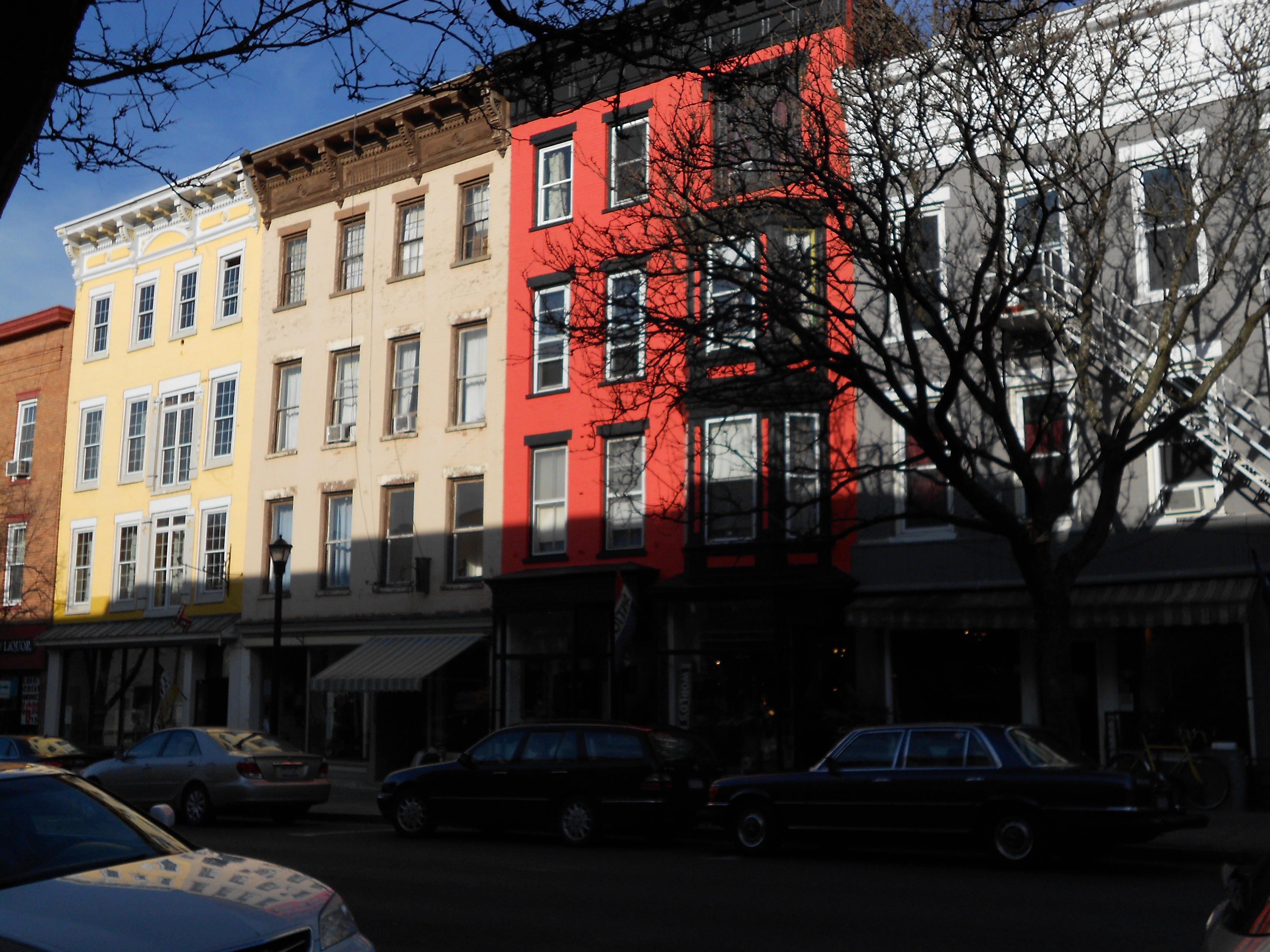
I am not in Salem for Small Business Saturday but I promise to make it up to my city’s small businesses when I return from my Thanksgiving holiday.  Today I’m going to feature another historic small city which is experiencing dramatic revival and redevelopment:  Hudson, New York.  Like Salem, Hudson was a bustling commercial port in the first half of the nineteenth century, only to realize a similarly spectacular decline in the twentieth.  Hudson is now being refashioned as an antiques center in particular and a distinct interiors shopping mecca in general.  Strolling up and down a historic city street while browsing carefully choreographed windows at merchandise that you don’t see anywhere and everywhere is my idea of shopping, and yesterday’s very civilized experience was highlighted even more by the repellent scenes from the mall that I saw on the evening news when I returned.

Some scenes from yesterday’s Hudson shopping excursion, all taken on Warren Street, the main street that runs right through the center of town:

Streetscapes, including the Hudson Opera House and a very carefully restored Greek Revival House just off Warren Street.

Some shop windows and signs, along with a really beautiful metal Christmas wreath in the center.

Shop interiors and merchandise:  Rural Residence, Hudson Home, Moderne, and (unfortunately) a few shops whose names I did not jot down.  EVERY shop in Hudson is worth a visit.


Past and Future in Ipswich

This past weekend we went up to Ipswich, about 12 miles north of Salem, to take a look at some very old houses and a very new wind turbine.  There is discussion of installing a turbine on Salem’s Winter Island so we wanted to check out the one in Ipswich, and there are lots of other attractions there:  cider doughnuts, beautiful beaches and farms, and the largest collection of First Period houses on the North Shore, perhaps even anywhere in America.  Here are some pictures of the largest and most famous one, the John Whipple House, built by 1677, moved to its present location off Route 1A in 1927, and owned and operated by the Ipswich Museum.

I love the very colonial clam-shell paths to the house and around the period “housewife’s garden”, the super-sloping roof and the windows–all of them.

And now for a contrasting view of the future in Ipswich:  the wind turbine, located on a large coastal DPW lot well out of the center of town.  Though both graceful and green, the turbine is indeed huge; it’s really difficult to see how it could possibly fit on the much smaller lot here in Salem.  There are a couple of shots here for perspective, including one across the marsh from the turbine.  I did not find it very noisy, however, which seems to be the other major issue with its potential siting.

On our way home (well sort of) we stopped at our favorite place in nearby Essex for friend clams:  J.T. Farnhams.  You eat your fried clams sitting on picnic tables overlooking the marsh looking back at Ipswich, and the house below, which I always think is going to be claimed by the marsh but never is.


UnGuarded

One more post on Salem’s Winter Island, where (in addition to Fort Pickering) there are two historical resources that have long been the focus of discussion and concern:  the former Coast Guard seaplane hangar and barracks/administration building, shown in “then (1938) and now” photographs below.

As you can see, these building have deteriorated dramatically following the closure of Air Station Salem in 1970.  Still, the new master plan for Winter Island proposes their rehabilitation and adaptive reuse.  I hope I am wrong, but it looks like it’s a little late for the Barracks Building, but a template for what could happen with the hangar is provided by the redevelopment of its twin in Miami.  The hangar at the former Coast Guard Air Station Miami at Dinner Key, built in the same year (1935) as the Salem hangar with identical plans, has been transformed into an adaptive aquatic center by the Shake-a-Leg Foundation in cooperation with the City of Miami. One possibility for a site with lots of potential.

Musters in Salem and Miami, from the Coast Guard Historian’s Office.  The Shake-a-Leg Aquatic Center in Miami with its rehabilitated hangar.

Another possibility, perhaps even more attractive as it involves year-round use, would be to convert the hangar into an indoor recreational facility.  The best example I could find of a pre-World War II hangar turned into a sports arena was in Seattle, where a private company transformed the historic Sand Point Seaplane Hangar #27 (built in 1938) into a sports club.  I think that the terms of the conveyance of the Winter Island site from the Federal government to the city of Salem would mandate a public venture, but hangars do seem to be well-suited to this particular use.

The former Sand Point Naval Air Hangar #27 in Seattle and the present Arena Sports Magnuson.  Architectural Design by Clark Design Group, Seattle.


An Unmarked Fort

Salem’s Winter Island has been the focus of a lot of attention this year, with the unveiling of a new master plan this summer and a proposed wind turbine on the table.  But it has always been a busy place, with a history of potteries, fishing and shipbuilding, executions and recreation, and above all, military installations.  The aerial photograph below was taken in 1955, at the peak of operations of the Coast Guard Air Station on Winter Island.

CGAS Salem, 1955, from the really neat site Abandoned & Little Known Airfields by Paul Freeman.

And a century before, in what looks like (and was) a completely different world, we have a 1858 lithograph of “Camp Banks”, an encampment of the Second Division of the Massachusetts Volunteer Militia on Winter Island just before the Civil War.

"Encampment of the 2d Div. of M.V.M. on Winter Island, Salem Harbor/Camp Banks", print by J. Bachelder, NY (1858)

Neither image indicates the most important, and long-lasting, military installation on Winter Island:  Fort Pickering.  This fort was established in the mid-seventeenth century as Fort William, renamed Fort Anne after 1703, and “Fort #2” by Patriot forces during the Revolutionary War.  After the Revolution, the Fort was named Fort Pickering after Timothy Pickering, Salem native and Cabinet member in both the Washington and Adams administrations.  It was rebuilt in several phases in the nineteenth century, and apparently tripled in size during the Civil War, when is was known as the Salem Barracks.  The Fort occupies the point in the bottom right-hand corner of the aerial photograph below, anchored by its lighthouse, Fort Pickering Light (1871).

After Air Station Salem closed in 1970, the Federal government transferred Winter Island to the City of Salem, which has maintained it as a recreational park.  The remaining Federal buildings have deteriorated considerably since that time, including those of Fort Pickering.  For the most part, Winter Island is maintained as a campsite, though this past summer camping was not allowed within the perimeter of the Fort.  I was happy to see that the new master plan called for improved signage and interpretive trails around the Island, as I think that this is a particularly pressing problem for the Fort site.  The succession of photographs below illustrate the problem:  the brass plaques that were once attached to stones around the Fort were apparently stolen, and replaced with markers that have not stood the test of time.

The entrance to the Fort:

Inside the perimeter of the Fort:

The Lighthouse:

Within the remnant walls of Fort Pickering, there is one plaque in excellent condition, though you have to really want to find it.  Attached to a gated powder magazine is a small brass plate In Memory of Fallen Special Forces Soldiers, its single permanence in striking contrast to the temporary rainwashed markers all around the fort.

I am glad that the proposed plan calls not only for improved signage, but also more formal interpretation of this important site as the historical record presents a confusing picture.  Even though there is firm evidence of its foundation in the mid- seventeenth century it was rebuilt so often in the succeeding centuries (including “demolition” phases) that we have to wonder what we are really looking at when we walk around the old fort today. Did the major expansions of 1794 and 1863 wipe out the remnants of the seventeenth century?  Hand-drawn pictures (below) from the charming Pictorial Fieldbook of the War of 1812 by Benson Lossing (1869), as well as literary and visual sources from the era of the Spanish-American War (the last time the fort was manned) testify to the existence of embankments and buildings that did not survive the twentieth century.  What exactly is left?  Recent archeological surveys of the site can best answer that question, and, when combined with the historical record, should tell a story that needs to be told.

In the clear: the remains of the Fort between the Wars

It is difficult not to compare the present state of Fort Pickering with a fellow “First System” fort of similar vintage: the better-preserved and -interpreted Fort Sewall in Marblehead.  As the master plan for Winter Island gets implemented in the coming years, perhaps this neighboring fort can serve as a model.


New Life for an Old Salem Church

Salem has been the scene of almost-continuous construction projects since I’ve lived here; some have changed the streetscape for the better, some for the worse (in my humble opinion).  One of the largest is nearing completion this summer:  the construction of a brand new “Judicial Center” on Federal Street adjacent to the previous courthouses, all sadly decommissioned.  This location is certainly appropriate, as this stretch of Federal Street is judicial Salem’s legal row, but it begs comparisons between the new center and the older courthouses.  Probably the architects (Goody Clancy) knew this, and certainly they received pressure from the preservationist community to retain something of what was on the site, especially as three nineteenth-century domestic buildings were taken down to make way for the HUGE boxy central building.  Consequently one building was retained and moved to serve as a link between old and new and a reminder of those days when architectural proportion ruled:  the former First Baptist Church of Salem.  Here is the church (now reconfigured as a law library) on the corner with the new complex behind and beside it.

The original location of the church was to the right and back a bit, where you see the large curtain wall now.  When it was moved several years ago (there’s a picture in an earlier post), it was not only moved forward but repositioned on a slight angle, following the lines of Federal Street.  This is one of the few concessions the entire project has made to the pre-existing streetscape.  Though the jury is still out for me on the entire complex, I think that  church/library is an important component, not only filling a gap but softening the transition between old and new, human-scaled and HUGE.  Below is the current streetscape on a recent rainy day.

From the foreground to the background we have the church/library, the new judicial center, which is comprised of the huge building behind the curtain wall (very imposing as you come into Salem along Route 114; I’m going to spare you a view for now) and the adjacent building with glass and columns, which (I guess) is supposed to effect another transition to the former Colonial Revival Probate Court, and then the Romanesque and Greek Revival court houses beyond. Below are some century-old shots of these court houses from the Library of Congress.  I’ve always found the Greek Revival one in the second picture to be really beautiful, and its the Romanesque neighbor has an amazing interior, including (of course) a law library.  I worry about these buildings’ fates.

It’s quite a succession of architectural styles, and then you get to the new complex, anchored by the old church/library.  The contractors not only repositioned the building, they repointed it and repaired its trim, revealing some beautiful details that I had never noticed before.  When I did look at this building before its big move, it did not strike me as particularly church-like, which is understandable given that it was stripped of its impressive steeple some time ago (in 1926, according to Bryant Tolles, Architecture in Salem).  Fortunately there are lots of accessible images of the church in its earlier form, making it all to obvious that this is a structure that has gone through several transformations in its two-hundred-year lifetime.

Photography credits:  a beautiful Frank Cousins photograph in the Urban Landscape collection at the Duke University Library, two undated postcards which I believe are from around the turn of the twentieth century, and two nineteenth-century stereoscopic cards from the New York Public Library Digital Gallery.


After the Fire: Orne Square

At the southern edge of the McIntire Historic District lies a mini-neighborhood of semi-detached English cottages, built of concrete in the early twentieth century rather than Cotswold limestone in the seventeenth.  This is Orne Square, laid out just after the great fire of 1914 under the auspices of the Salem Rebuilding Commission, with financing from the Salem Rebuilding and Phillips Trusts, and with inspiration from the dynamic Arts and Crafts and English  “Garden City” movements so popular at the time.

Each of the eight houses features two separate three-story townhouses with separate entrances and side and back gardens; there are common parking, lawn and garden areas as well.   The elbow-shaped Orne Square is a Salem public street, not a gated community, but  I don’t think there is a lot of cut-through traffic.  It’s a great little neighborhood.

Just around the corner from Orne Square is another English Arts and Crafts double cottage, a perfect example of the type of “reform housing” that the Boston architectural firm Kilham and Hopkins was proposing for other fire-ravaged areas of Salem.  This firm was waging a war on triple-deckers all over eastern Massachusetts, and their consultations and advocacy resulted in strict guidelines for the rebuilding of Salem and a strong preference for side-by-side double houses rather than multi-story buildings.  I’m not sure if Kilham and Hopkins are responsible for the Orne Square houses, but they did design and build a neighborhood of  “low rent brick cottages”   in North Salem, as well as the Woodbourne section of Jamaica Plain in Boston.

Architectural Forum 28 (1918)

Plans for Woodbourne

I’m reaching here for a bit more geographical and architectural context, but Orne Square seems like a smaller, less commercial version of the Hydrostone neighborhood of Halifax, Nova Scotia, constructed after the devastating 1917 explosion and fire following the collision of a French munitions ship and a Norwegian supply ship in the harbor during World War One.  I’m visiting there later in the summer, so I’ll see if the comparison stands.


The Willows in the Aughts

Inspired by my student’s paper and Maurice Prendergast’s painting below, and hoping for a bit warmer weather, here are some views of Salem’s seaside amusement park, the Willows, during its golden heyday at the turn of the last century. Formerly Salem Neck, the site of a smallpox hospital (for which its namesake white willow trees were planted around 1801, with hopes of creating a tranquil convalescent setting) and adjacent farmland, the Willows became a municipal park in 1858 and was further developed and expanded with arcades, “Restaurant Row”, and adjacent vacation cottages from the 1870s.  Two maps below, from the early and late nineteenth century, show its early development and connection to the main part of Salem.  The first map, from the Norman B. Levanthal Map Center at the Boston Public Library, shows an almost completely rural Salem Neck in the upper right hand corner while the second, from the Phillips Library of the Peabody Essex Museum via Salem State’s grant website Salem in History, illustrates a much more connected Willows.

 
The Salem Willows Amusement Park never rivalled the larger Coney Island-esque parks like Revere Beach to the south and Old Orchard Beach to the north, but it was an extremely popular local recreation destination for factory workers from nearby Lynn and the Merrimack Valley, who would take the train to Salem Station and then hop on one of the horse-drawn trolleys which travelled to the Willows every 15 minutes or so in the summer.  Once there, they found restaurants and picnic grounds, beaches for sunbathing, arcades, a casino, and the Pavilion, “flying horses” (a carousel) and an open-air theater, outgoing steamships, and lots and lots of people:  by several estimates as many as 10,000 a day on a summer weekend.  Much of the recreation that occurred at the Willows seems to have taken the form of promenading, a nice old-fashioned word (and activity) that is very well captured by Maurice Prendergast’s 1904 painting Salem Willows, the alternative title of which is Promenade, Salem Harbor.
 
 
Like Prendergast’s painting, postcards from the era (which must have been issued in the thousands, so many survive) convey the spirit of lazy, breezy promenading (by well-dressed people!) under the Willows.  Here is a sampling, all from just the 1906-1910 period. 


This last picture, from 1910, is prescient of things to come:  the automobile will certainly change the Willows in a myriad of ways over the coming century: bringing about the end of its strictly summer identity and the creation of year-round neighborhood of Salem.  While few of its turn-of-the-century structures still stand today, the Willows Park maintains a seasonal and somewhat timeless air about it, but adjacent Juniper Point has changed quite a bit, evolving from “tent city” to cottage colony to year-round residential community.


Preservation: Gains and Losses

Historic preservation has been an ongoing effort in Salem since at least the second World War, when the seventeenth-century Jonathan Corwin house (later, unfortunately, labelled the “Witch House”, was threatened by a street-widening project and Historic Salem, Inc. (HSI) was formed by a group of citizens determined to save the house.  They were successful, and HSI (along with other individual passionate preservationists) has gone on to fight urban renewal, save a succession of historic structures, and advocate for both individual restoration and adaptive reuse projects as well as a more general planning policy encompassing historic preservation.  There have been losses and gains over the past half century or so, both of which have had a dramatic effect on Salem’s streetscape.

Two projects of the last decade represent the dynamic of gain and loss in the continuum of preservation advocacy very well.  Most recently the very shabby Elks Lodge was transformed into the stately One Eaton Place Condominiums, a rehabilitation that is even more impressive given the building’s prominent place along one of Salem’s entrance corridors, North Street.  When HSI, which had a vested interest because its headquarters are immediately adjacent to this building as well as a more general preservation concern, informed the developers that their newly-purchased building had somehow lost its third story at some point in the twentieth century, they were more than eager to put it back and gain additional units at the same time.  This was a win-win for everyone, and (in a tough real estate market) the condominiums sold out within months of completion of the project.

In the loss column goes one of the most hard-fought preservation efforts in Salem’s history:  the effort to secure the redevelopment of the 1908 Salem Armory after its partial destruction by fire in 1982.  The imposing (many architectural adjectives come to mind:  fortress-like, castle-esque, Romanesque/Gothic/medieval revival) structure, long home to the Second Corps of Cadets of the Massachusetts National Guard, dominated several blocks of central Essex Street right up to its demolition in 2000, even after the 1982 fire, as these before and after images illustrate.


A Frank Cousins photograph of the Armory Billiards Room, c. 1910. Duke University Library Special Collections


HABS, Library of Congress

Ten years after the fire, 1992

At about the time of this last photograph, the newly-formed and adjacent Peabody Essex Museum (a merger of the Peabody Museum and Essex Institute) entered into a memorandum of agreement with the Massachusetts Historical Commission and other parties to incorporate the street-fronting “head house” into its expansion plans while the National Park Service proceeded to transform the rear “drill shed” into a Visitor’s Center.  Throughout the 1990s, the Museum delayed and eventually reneged on its agreement, transferring its expansion focus to the present Moshe Safdie-designed atrium addition across the street.  HSI initiated a legal action to save the head house but to no avail:  it came down in 2000.  In its place, the Museum left only the Tudor arch entryway standing (presumably to maintain some semblance of streetscape) and promised a “world-class” Armory Park to honor the Second Corps of Cadets.

I’ve always found the stand-alone entry a bit ghostly; it’s an architectural memento mori.  Amory Park is not really a place, but simply a pass-through path to the Salem Visitor’s Center beyond, which is a great resource for both Salem’s residents and visitors.  May is Preservation Month, a time to look around and remember both what has been saved and what has been lost.


Envisioning Essex Street

Essex Street has been Salem’s main street since its foundation.  The architectural diversity of the streetscape in its residential sections is amazing, and in its heyday (before the building of the Northshore Shopping Center in 1958) its commercial blocks drew people from all over the region.  I think there must have been several Essex Streets for some time, but this partition was formalized with the creation of the Essex Street Pedestrian Mall in the 1970s–barring cars from the city center.   The attitude of Salem’s residents towards the mall strikes me as rather intense; people either love it (or love the concept of  it but think it needs updating) or hate it, and that’s why I’m looking forward to tonight’s  “Essex Street Pedestrian Mall Visioning and Conceptual Design Meeting“.  This is the first of four scheduled public forums on the street’s rehabilitation and potential redesign sponsored by the City of Salem, the  Salem Partnership, and the Peabody Essex Museum. For some historical perspective on this envisioning process, here are some images of central Essex street, past and present.

First up are two stereoviews produced by George K. Proctor of Salem of Essex Street  from Washington Street or Town House Square and one of the East India Marine Hall further down the street.  These were published in the 1870s and 1880s and can be easily accessed at the New York Public Library’s Digital Gallery.

The most popular perspective, from Washington Street across from the Daniel Low building, looking east along Essex Street from the 1880 Visitors’ Guide to Salem.

WIRES AND TRACKS:  a very connected Essex Street below, again viewed from Washington Street/Town House Square, in a photograph issued by the Detroit Publishing Company in the first decade of the twentieth century(Library of Congress Digital Collections).

BUSTLING BUSINESSES:  A series of postcards, all dating from the early and mid-twentieth century.  Salem had at least three movie theaters along several blocks of central Essex Street, all gone now, but fortunately we have the Cinema Salem on Church Street.  What I notice most about these postcards are big stores (Woolworth’s), signs (Chop Suey!), awnings, and crowds.

Two views of Essex Street in the present, from the perspective of the silly Samantha-from-Bewitched statue in Town House Square.  Note that the pedestrian mall is not closed to all cars.