Tag Archives: Streets of Salem

Salem 1897

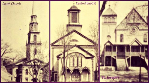
Salem 1897: William McKinley was President of the United States, Roger Wolcott was Governor of Massachusetts, and the Salem Evening News published an Illustrated History of Salem and its Environs, which includes photographs of many mustachioed men, their residences and places of business, and some of the city’s more notable public landmarks. Despite its title, it’s not really a guide to historic Salem (although there is a little narrative history of the city from its founding) but rather a visual “state of the city” in that very year, from a decidedly commercial point of view. Sometimes it is interesting to just swoop in and look at the lay of the land of a particular place and time, so that’s what I’m doing today. I don’t believe that there is a single featured woman in the entire publication: one would think the city was made up of white men except for sights of women and children in the distance: waiting for a train or the beach. And while we see many exterior views of factories—particularly tanneries—we don’t get to peer inside and see any work being done, by men or women.  Even with these limitations, it’s an interesting book, especially for one (such as myself) who is interested in built history: it allows us to see Lafayette Street before the Fire, a very busy Bridge Street, and many lost churches—and the engraved illustrations are particularly nice.

Salem 1897 Cover

Salem 1897 Courthouses

Salem 1897 Derby

Salem 1897 Jail

Lost Churches

Salem 1897 Illustrated_History_of_Salem_and_Environs_1897_0032 Y

Salem 1897 Mercantile National Bank 225 Essex @ 225 Essex Street.

It’s always interesting to see anachronistic trades and businesses in publications such as this as well: anything to do with horses, all those tanneries and factories, lead works, house movers (moving houses rather than the contents of houses): there were two in Salem!  This was a city full of houses of worship and work, many stores, and many banks–and not so many restaurants. The usual public institutions are featured as well: I think we’ve all seen enough old photographs of the Salem Public Library, the Essex Institute and Peabody Museum, various schools, and our famous, beloved Gothic fortress of a train station, so I have foregone those images in favor of less-broadcast ones here. Salem appears to have been thriving in 1897, though somewhat sparsely-populated in this (re)presentation—except for all those mustachioed men!

Salem 1897 37 Bridge Street

Salem 1897 Parker

Salem 1897 Store

Salem 1897 Almys

Salem 1897 Storage

Salem 1897 Lynch on Skerry

Salem 1897 Forest River

Salem 1897 Illustrated_History_of_Salem_and_Environs_1897_0129

Salem 1897 Fairmount Street

Salem 1897 Gorman

Just a few of the businessmen featured: Messers Almy, Bigelow, Washburn & the three Vaughn brothers.

Mustache Men


Let There be Light

Maybe it was just me, but it seemed as if Halloween was spilling over into Christmas this year in Salem, with “Haunt the Halls” and “Grave Tidings” markets offering up dark wares and bats popping up in nearly every shop I entered: adorning jewelry, candles, and walls. Now I really do like bats, but they are not my creature of choice for this particular season; I would rather see deer, rabbits and sheep, squirrels and foxes—and fluffy fake stuffed versions of the latter rather than the taxidermy example I encountered at one downtown shop, right alongside a box of bones and more bats (real stuffed). Thankfully I was able to find light in several other shops with more cheery merchandise, the city’s bustling restaurants, and all along the streets, with so many houses lit up for the season: because we have quite enough darkness at this time of year, thank you very much. I have wanted to do more posts featuring Salem at night for quite some time, but my photographs never turn out very well. I took all the advice that was offered on the web, and began my photo safari at dusk as recommended, and I think I came up with some pretty good shots, but for every image you see below there are about six or seven blurrier examples. I felt a bit voyeurish sneaking up on all these Christmas trees but that’s why they are in the window, right? And all those lights are why Christmas is so great in the city–much more so than silver bells these days.

Light Best

Light 2

Light best 2

Light windows 2

Light 4

Light 5

Light Stacia

Light McIntire

Light magnificent

Light 11

Light Dark

And a blur of red: Lunch for Santas and Paxton’s penguins at dusk and later.Santa Lunch

Light RedMerry Christmas!


A Carnival in Salem, 1906

I was pleased that a proposal to situate a commercial carnival for the city-wide celebration of Halloween on Salem Common was abandoned by our Mayor a few weeks ago, but many people in Salem were not. The carnival is a private enterprise, but it serves a public function: the crowds that come to Salem increase with every year because of the profitable association of the 1692 Witch Trials and Halloween and crowd control measures are needed. Apparently the carnival serves in that capacity, and also provides a place for families and teens who have had enough of the haunted houses, tours, and “museum” offerings that form the regular fare of Haunted Happenings. So after the Common was ruled out, the City sought other locations for the carnival (even at this late date!) and have come up with one in the vicinity of the courthouses on Federal Street. This seems like an even more disruptive location to me but the increasing requirements of Haunted Happenings trump everything in this City. Over the past few weeks, the public discourse about the Carnival and its location was really interesting, so I sought a bit more historical context. Salem has quite a history of public civic celebrations, but I think the best precedents for its Halloween carnivals of the past decade are the turn-of-the century “trade carnivals” that were sponsored by the Merchants Association. The carnival of 1906 opened on this very day, and was held in and around Town House Square, not too far from where the 2018 carnival will be held.

Salem Carnival 1

This was quite the extravaganza! I have looked everywhere for a photograph of the Japanese pagoda with its 1286 incandescent lamps, with no luck, and it’s difficult for me to see how it would fit in Town House Square (see postcards below). The display of electricity must have been awe-inspiring at this time, as well as the other attractions: near the courthouses (perhaps in the same location of the 2018 carnival), a stereopticon and moving pictures were continuously exhibited on a screen for the duration of the carnival. This was a display of media-in-transition, as the stereopticon, a double-lensed “Magic Lantern”, is widely recognized as a key forerunner of films. Electric cars from all the neighboring towns brought “thousands” of people into Salem for the festivities, all greeted by “‘Welcome’ signs [with] letters formed of small electric lamps in several locations”. Two years later, we can read (in the Boston Globe) about an even bigger trade carnival held in late April: commercial life was not so exclusively connected to exploiting the Witch Trials/Halloween at this point in time, although it was definitely a growth industry. The 1908 carnival featured an elaborate opening parade with the Mayor (Hurley) on horseback, merchant (princes) in barouches, and the entire Fire Department of Salem, with their muster-winning handtub engine the White Angel, “which made a fine show”. Schools were closed for the occasion, and once the carnival was officially opened, there were band concerts in (again–what must have been a very crowded) Town House Square every afternoon and evening.

Carnival Town House Square

Carnival Town House Square 2

Carnival Ridgway_Stereopticon_Advertising_Co_36_Cambridge_St_Boston Boston Athenaeum

Carnival White Angel Salem2_3029_2048x2048PEMContemporary postcards of Town House Square; Ridgeway Stereopticon Advertising Co., trade card, Boston Athenaeum (I imagine the Salem screenings looking like this); a great photograph of the famous White Angel handtub from the PEM’s Phillips Library, published in Pediment ‘s Salem Memories, Volume II and available here.


A Memorial Map of Olde Salem

The 1920s was a decade of intensive commemoration in Massachusetts, in recognition of the 300th anniversaries of the landing at Plymouth in 1620 and the arrival of John Winthrop here in Salem in 1630, bearing the royal charter that formally recognized the Massachusetts Bay Company. The commemoration culminated with the formation of the Massachusetts Bay Colony Tercentennial Commission in 1929, which oversaw thousands of events, including processions, pageants, historical exercises, old home weeks, exhibitions and expositions, the publication of various commemorative materials like Massachusetts on the Sea and Pathways of the Puritans, and the erection of roadside historical markers across the Commonwealth (the Salem markers are all “missing”—I’m coming to the unfortunate conclusion that there has been a long cumulative campaign to remove as much of Salem’s tangible history as possible, with the relocation of the Phillips Library as the end game! Maybe we are cursed–or maybe I’ve lost my perspective).

Pictorial Stamp.jpg

Smithsonian/National Postal Museum

There was also some sort of map initiative: as I’ve found several pictorial/historical maps–of the commonwealth, various regions, and individual towns–published in this period, often by the Tudor Press and under the auspices (and with the approval) of the Tercentenary Conference of City and Town Committees. Elizabeth Shurtleff’s Map of Massachusetts. The Old Bay State (which is in the Phillips Library but fortunately also in David Rumsey’s vast digital collection) is one such map, and there are others representing Cape Cod, Cape Ann, Boston, and several other Massachusetts towns and cities. As you can see from the cropped images of James Fagan’s map of Shawmut/Boston 1630-1930 and Coulton Waugh’s map of Cape Ann and the North Shore, these maps were “historical” in an extremely subjective way, emphasizing achievements above all. As explicitly stated by Fagan, they pictorialize progress above all. I’m sure that this message was particularly important given the coincidental timing of the Massachusetts Tercentenary and the onset of the Great Depression.

Pictorial Map Shurtleff

Pictorial Map Boston

Pictorial MAP Cape Ann

So far, I’ve seen 1930 pictorial/historical maps of Ipswich, Concord, Nantucket, Martha’s Vineyard, Cambridge, and the other day, while looking for something altogether different in the digital collections of the Leventhal Map Center at the Boston Public Library, I came across of one of Salem! Very exciting–I thought I had chased down every Salem map in existence but no, there was (is) The Port of Salem, Massachusetts by Warren H. Butler, published by the Tudor Press in 1930. This is a perfect Colonial Revival map really, focused on recreating a rather whimsical/historical “olde” Salem rather than tracing the path of progress. I love it, even though my own house seems to have been swallowed up by an extended Hamilton Hall on lower Chestnut Street. It’s hard to date this map: in the accompanying text, Butler says “here are the ancient streets of Salem”, but while the streets depicted seem to be vaguely Colonial, the buildings that line these streets are of varying periods. His Salem is a port city first and foremost, but while he includes ships in both the harbor and North River and Front Street is really Front Street, the massive Gothic Revival train station is here too. Samuel McIntire’s courthouse is located in its historic location on Washington Street, just a few steps from the Greek Revival courthouse that still stands, vacant, in Salem. All of the Derby houses are on the map, including the majestic–and ephemeral—McIntire mansion which once sat in the midst of present-day Derby Square. In fact all of my favorite Salem houses, still-standing and long gone, are on Butler’s map: it’s a historio-fantasy map of non-Witch City, and I want to go there!

Pictorial Port of Salem

Pictorial Salem 2

Pictorial Salem 1

Pictorial Salem 3

Pictorial Salem 4You can zoom in on Salem’s “ancient” streets yourself at the BPL’s Leventhal Map Center.


Locals Lean In

It seems to me that there has always been a correlation between dissatisfaction with the Federal (or central) government, in general or focused on a particular branch, and action, manifested not only by large protest marches with lots of speeches but also by intensifying local engagement and activity: the latter does not loom as large on the radar screen as the former but is just as important, if not more so. It is these smaller, community initiatives that make me feel hopeful just now, although Salem has been a rather engaging and engaged place for as long as I’ve lived here. The city government is progressive and multi-layered, with the usual planning boards supplemented by committees made of citizens striving to make Salem beautiful, “no place for hate”, bicycle-friendly, and greener. There are venerable philanthropic organizations–mostly initiated and administered by women–that are still alive and well today in Salem, more than a century after their inception. Every cultural and/or historic organization has its dedicated band of volunteers. And then there are the newer, very focused initiatives, oriented for the most part on the livability of the city. Even though Salem is a small city, it’s still a city with visible urban problems, including most prominently litter, traffic, and crumbling hardscape. Even though I’d love to see its historic downtown cemeteries roped off altogether, I still applaud the efforts of the newly-formed Friends of Salem’s Historic Downtown Cemeteries whose mission is to advocate “for the protection and preservation of the Old Burying Point, Howard St and Broad St Cemeteries”. The city of Salem has a Cemetery Commission but it’s not enough; these well-trodden downtown cemeteries need more. Our other public spaces need advocates too, which is why I also applaud the Salem Public Space Project,  a “collective effort to engage residents in understanding and reimagining local public spaces”, and the Collins Society, which focuses on highlighting and preserving the work of Philadelphia landscape architect John F. Collins, who took over after urban renewal was abandoned in Salem in the early 1970s. The Society maintains a lovely website with some great images, and seeks to improve and preserve the urban streetscape (including fountains, plazas, planters and cobblestone paths) of downtown Salem, for “landscape architecture…should be preserved with the same dedicated passion as architecture”. Last but certainly not least, I really applaud the daily efforts of FireballsofSalem to cleanse the city of its constant supply of nip bottles and other annoying forms of litter. Valiant, hopeful initiatives all.

lli-cemetery

lli-lafayette-park

lli-derby-square

lli-derby-square-2

lli-planning

lli-nip

lli-nips

The Old Burying Point on Charter Street and and Lafayette Park, a public space that needs some attention and will be getting it in 2017; The plazas and pathways of John F. Collins in central Salem: why are cars parking on those cobblestones on the left which are clearly not parking spaces? Fireballs are the preferred “fleur de Salem” of the Fireballs initiative but I’ve been finding more of these little green Dr. McGillicuddy bottles recently: I think they were specially priced for the holidays.


Trudging Along

Yesterday was a beautiful winter day with everyone out and about cleaning up after the Saturday snowstorm, which was not as bad north of Boston as it was to the south.The streets of Salem were clear by mid-morning, if not before (I was sleeping in), and people were engaged in their regular Sunday activities. There were Sunday street-hockey players out my front windows, and hungry birds out back.

snowy-chestnut-street-hockey-game

snowy-garden

I suddenly became curious about snow removal in the past–mostly because I didn’t want to go out and engage in my own snow removal in the present. I have–and have seen–quite a few historic photographs of winter scenes in Salem in the later nineteenth and early twentieth centuries, but none of them feature snow carts, snow plows, or snow removal. Salem has always been quite urban, and people needed to get around, how did they manage? What was the system then that so preoccupies us now? Both the New York Public Library and the Boston Public Library have quite a few photographs of various methods of snow removal in their collections, from simple shovel brigades to “snow rollers”–I’ve never seen anything like that for Salem: anyone out there have anything?

chestnut-street-in-winter

lafayette-street-in-winter

Chestnut and Lafayette Streets in the 1870s in stereoviews by Charles G. Fogg. Carriages on the snow—not even sleighs! But it’s not too deep here.

snow-chesnut-st-2-harvard

snow-chestnut-street-1899-harvard

Chestnut Street in the 1890s, deeper snow, no signs of plowing–but these carriages do look like they are on blades. I’ve shown these before; they are from a family archive in the Schlesinger Library at Harvard.

My problem is that I don’t have any winter scenes of Washington or Essex Streets with tracks that needed to be cleared: Chestnut was and remains strictly residential. I still think people trudged around a lot more than we do now, however. Look at these two wonderful photographs of students from the Horace Mann “Training School” associated with the Salem State Normal School (now Salem State University, where I teach) and their teacher, visiting historic sites downtown in the snow.Look at her skirt: she’s not troubled by a little snow.

snow-and-students-collage

E.G. Merrill photographs of Horace Mann students, 1904, Salem State University Archives and Special Collections

Like everything else, our toleration for snow in the streets changed with the automobile: we won’t settle for anything less than black the day after a snowstorm now. The wonderful book by Marblehead artist, photographer, and author Samuel ChamberlainSalem in Four Seasons (1938) shows winter streets cleared for cars and pedestrians. And he agrees with me: some of Salem’s most beautiful moments are in winter, when few visitors see it (though a lot more now, fortunately).

chamberlain-four-seasons

Plowing Chestnut Street in the 1930s, from Samuel Chamberlain’s Salem in Four Seasons (1938).


What became of the Pineapple House?

There was a large Georgian house in Salem referred to by all as the “Pineapple House” for its prominent door decoration. It was built by Captain Thomas Poynton at some point between 1740 and 1750 on Brown Street near Salem Common, and later moved to an adjacent court off the main street. Today neither the house or the court exist: I’ve been trying to determine what happened to both with little success! According to the Genealogical Memoir of the Driver Family (1889), the frame of the house was brought from England by Captain Thomas Poynton, husband of Mrs. Hannah Poynton (Bray), in one of his own ships as early as 1740. This house still stands in 1887, in a most excellent condition, but not on its original site, having been moved some hundred feet to make room for a house built for Mr. Stephen Ives (no. 40 Brown Street) whose heirs are the present owners of the Pine Apple House. My hero, the photographer-preservationist Frank Cousins, took several photographs of the house and its famous doorframe in the 1890s and 1910s, and I can find references to its existence as late as 1923. It came down sometime after that, and after the door frame (with pineapple) was donated to the Essex Institute, where it was installed in the Phillips Library.

pineapple-house-cousins-duke-ulThe Captain Thomas Poynton House, 7 Brown Street Court, Salem. Photograph by Frank Cousins, Urban Landscape Digital Collection, Duke University Library.

Captain Poynton was a Loyalist, proudly whitewashing his chimneys and incurring the wrath of an angry mob which attacked his house in 1775, breaking many windows and inspiring him to depart for England. He left his wife behind (this happened so many times in Salem! What a great dissertation topic), and never returned to America. Mrs. Poynton seems to have been everyone’s favorite aunt, and she was devoted to the upkeep of the pineapple atop her front door, which apparently also came from England, painting and regilding it annually and ensuring that the curtains of her second-floor window never obscured its profile.

pineapple-doorway-poynton-house-cousins

pineapple-house-cousins-1911-12

pineapple-doorway-visitors-guide-1895

the-stairway-and-pineapple-door-essex-institute-salem-mass-pc

Two views of the Pineapple/Poynton House doorway by Cousins; as illustrated in the Essex Institute’s Visitors’ Guide to Salem, 1895;  the door frame and pineapple in the Phillips Library of the Essex Institute, Detroit Publishing Company postcard, after 1912.

The pineapple continued to be well maintained until its detachment and donation, but the rest of the house was expanded considerably in the rear (see above), enabling its transition into “tenement” status in the later nineteenth century. As indicated above, it was moved, and then sometime (1920s or 1930s?) it disappeared, leaving only its famous pedimented doorway and Cousins’ photographs behind.

browwn-street-court-map

brown-street-court-today

Brown Street Court (just below #49) on a map in an undated Essex Institute brochure titled “A Tour of Salem”; Brown Street  Court today (I think!)–looking towards the Church of St. John the Baptist on St. Peter Street.


Salem 1912

I stumbled across the “first annual” Report of the Salem Plans Commission the other day, and read it with rapt attention. This was issued at the end of 1912, a time when the city’s population had experienced rapid growth and housing was in short supply, the waterfront was “decayed”, and downtown (trolley) traffic was at a standstill. There were startling parallels to Salem 2016 in the Report, starting with its opening assertion that Salem is known quite literally with a single tolerable entrance or exit and (possibly excepting Loring Avenue) we must admit that this is quite literally true, whether we travel by foot, carriage, automobile, trolley, train or boat. While the Commission asserts that Salem’s entrance corridors, called “gateways” in the report (a timely term now) all needed work, they are clearly advocating for more immediate attention to the city’s key transportation network: the combination of trains and trolleys that drove external and internal traffic. Salem’s main gateway was identified as the Boston & Maine Depot, and the arteries that commenced from there were apparently in dire need of widening and expansion in the forms of a”ring road”, a “shore drive”, and a street system. The entire report calls for a more systematic Salem in every conceivable way: roads, parks, housing, zoning.

Salem Train Depot 1912Salem’s Gateway, 1912

The commissioners write with a very strong voice, one voice, and express stark opinions throughout their report: the congested wooden housing in The Point is a “fire menace” (a prescient observation, given it would be leveled by the Great Salem Fire in two years) which evolved through “selfish gain driven by public indifference”, the waterfront must be “redeemed”, the North River is a “stinking open sewer”. They are so assertive that what one would think would be a rather dry text makes for riveting reading!

Salem 1912 North River

Salem 1912 Billboards on Bridge Street The “Stinking” North River and “Billboard Adornment” on Bridge Street.

In order to achieve their vision for Salem, the Commissioners include lots of detailed recommendations which are both utilitarian and aesthetic. They are aware of the significance of Salem’s material heritage but I would not call them preservationists: if an old building is interfering with trolley traffic on a narrow street it’s got to go! They seem particularly focused on Central and Lynde streets as problematic for traffic flow, and their recommendations seem to be the inspiration for the consolidation of the former Elm and Walnut Streets into a widened Hawthorne Boulevard.

Salem 1912 Central Street to Essex St

Salem 1912 Washington and Lynde Streets

Salem 1912 North and Lynde Streets

Salem 1912 Lynde Street from North St

Salem 1912 North and Federal Streets

Salem 1912 Elm and Walnut From above: Central Street looking towards Essex; the intersection of Washington and Lynde Streets; two views of the intersection of North and Lynde Streets; a trolley turning onto Federal Street; Elm and Walnut Streets.

I think Commissioner Harlan P. Kelsey was the author of the report, but I can’t confirm this as it was simply published by the “Plans Commission”. Kelsey was a really prolific landscape architect who lived in Salem (at One Pickering Street–this was the house that distracted me from Kelsey’s story to that of its architect, Ernest Machado) and, in addition to his landscape and planning practices, also maintained two profitable nurseries in his native North Carolina and adopted city. I’ve read his writing on plans and parks elsewhere, and it sounds familiar, and the last part of the Report is devoted to the shoddy condition of Salem’s shade trees—another timely topic!

Salem 1912 Broad ST

Salem 1912 Lafayette 
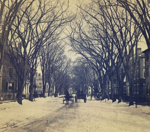
Two Salem streets which the Commissioners actually LIKED for both their width and their trees: Broad and Lafayette. Both would be half-leveled by the Great Salem Fire in 1914.

All photographs from:  City Plans Commission, First Annual Report to the Mayor and City Council, December 26, 1912.  Salem: Newcomb & Gauss, 1913.


%d bloggers like this: