
Salem is currently in the midst of implementing another urban renewal plan under the supervision of the Salem Redevelopment Authority (SRA), the board that was created by the city’s first urban renewal plan in the 1960s. The story of the implementation of that plan is a pretty established narrative: over-ambitious SRA orders destruction of much of downtown and advocates for the construction of a highway into central Salem to increase access for shoppers lured away by the North Shore Shopping Center in Peabody until concerned citizens’ protests and the New York Times architectural critic Ada Louise Huxtable’s extremely influential article brought national attention to the imminent destruction of Old Salem, shifting “renewal” towards redevelopment and preservation. Well, obviously I’m simplifying a much more complex process with many players: I’m starting to go through some of the sources which documented this process so I can understand it a bit better. I thought I would start with the early 1960s vision, as expressed by a series of reports issued by Blair and Stein Associates of Providence, RI, a planning firm hired by the City. Blair and Stein supposedly produced seven reports for the Salem Planning Board: I have found only three so far and the “Central Business District” report the most interesting: Salem, Massachusetts : central business district / prepared by Blair and Stein Associates in cooperation with the Salem Planning Board and the Massachusetts Department of Commerce (1962).

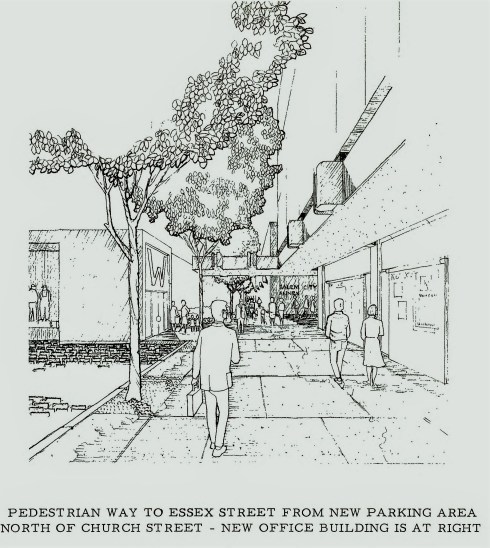
This study and its recommendations was not as focused on “tear it all down” as I expected: there are definitely recommendations for clearances, but also for preservation. Blair & Stein believed that the North Shore shopper, who is always referred to as “she,” could be lured back to downtown Salem if “blight” was cleared away and access improved. There are many references to urban blight, which was perceived as both decay and the reign of “inappropriate” facades and signs: after those were removed the state and fate of the stripped building should be considered. Because the emphasis is on renewing Salem’s shopping district above all, parking is very important, as is the overall design of pedestrian avenues around the downtown. Thus they gave us a pedestrian mall on Essex Street, Salem’s main street, but also on secondary routes leading into it. Salem would become an outdoor mall, with a mix of old restored buildings and new complementary structures: complementary not “imitative,” which is what I think most people would like to see now. It’s just annoying when advocates of sub-standard new construction accuse anyone who argues for higher standards of trying to turn Salem into a faux Federal city: I like the language below emphasizing scale, texture, character and “spirit” of new construction and did not expect to find it in a document of this nature and vintage.


Interesting spelling of “aesthetic” but these are goals I wish we were shooting for now!
Apart from the concerns about blight, parking and aesthetics, the major difference between this plan and the current one relates to housing: Blair and Stein envisioned a distinct shopping and cultural district and did not advocate for the expansion of residential buildings downtown, while that is a major planning goal at present. While they referenced tourism, they clearly saw it through a regional focus rather than a national one, and they don’t even mention Halloween. Salem would be a city of day trippers and day shoppers, returned to regional hub status.


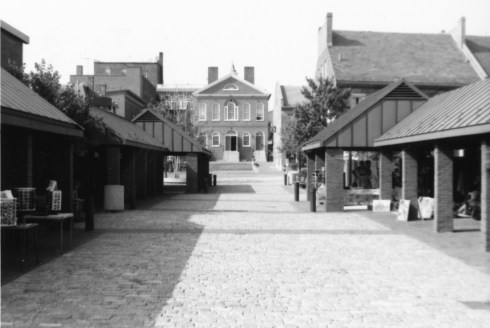
Deed restrictions prevented all that planned Front Street parking, and inspired Artists’ Row, here pictured in 1978, Salem State University Archives and Special Collections.
The schematic sketches are just that, clean and orderly, and now I am seeking the specifics of how this rather vague plan turned into the scary plan of action recorded in the Boston Regional Office of HUD several years later: The Heritage Plaza East project advanced from the planning stage to the execution stage in February 1968. About 40 structures in the area will be rehabilitated, 140 will be razed, and 75 families will be relocated in the process of clearing the area. CLEARED OUT. The records of the SRA, which for some reason are deposited in the Phillips Library, will certainly shed light on the “progress” from planning to execution.
Appendix: Historic Salem, Inc. has prepared a “Citizens Guide to the Downtown Renewal Plan” for those who wish to engage with its implementation, available here.


April 27th, 2021 at 8:56 am
The perennial problem, as I see it, is that municipalities spend millions on these “renewals” and a pittance on routine maintenance that will guarantee the survival and viability of the structures, roads and walkways that we now have. How often have we seen road crews tear up paving stones and bricks on the Essex St Mall and replace them with macadam patches instead of the small effort it would take to replace the original? Private enterprises neglect routine maintenance, too. Will PEM let the magnificent Andrew-Safford House fall into ruin before they have to raise millions to “renovate”? We need to replace neglect with TLC. It’s as simple as that. Joni Mitchell sang it well: “Don’t it always seem to go that you don’t know what you’ve got till it’s gone”.
April 27th, 2021 at 9:22 am
I couldn’t agree with you more, Terry. The care that was taken with these pedestrian walkways, plazas, islands, and all the hardscape in the eventual implementation of Salem’s first renewal plan is all too obvious, and they simply haven’t been maintained by the City.
April 27th, 2021 at 9:23 am
It’s important to note what this report was responding to: the opening of 128 in the early 50s drew traffic away from the coastal route, and the advent of Northshore later in the decade destroyed downtowns from Lynn to Gloucester as shopping destinations.
April 27th, 2021 at 9:34 am
Yes, that’s very apparent in it: the whole first section describes that process, but it’s authors believed (or asserted) that Salem could lure customers back with increased accessibility and design.
April 27th, 2021 at 1:09 pm
I have some photos & informtion withina the material at the SSU Archive. I have not had access to what I have placed on dposit for far too long. I do have the original George O. Gagnon series of color photos. He took a roll of photos in May 1969. The phhootos show many buildings that were torn down shortly after. The set of potos are priceless as thy were taken on Kodak film that has not faded, or degraded over the years I also .have a batch of 36 B&W photos taken by a tourist. They show the city circa 1981.
The photos begin in Town Hose Sq, and end on Derby St. I have not had a chance to see the material in my collection for ffar too long. But it is siting
unused at SSU..
April 27th, 2021 at 1:10 pm
Ok, Nelson, I will check them out!
April 27th, 2021 at 3:51 pm
I’ve always loved Jane Holtz Kay’s book, “Lost Boston”. Is there the like about Salem? We can look and weep!
April 27th, 2021 at 3:38 pm
There are a few of those Arcadia books, then and now, and also the Salem News put out a few “memories” books—I think a more integrated presentation would be popular! I love Lost Boston too.