Monthly Archives: July 2016

24 Hours in Richmond

Just back from an abbreviated visit to Richmond, Virginia for a family event: shortened by the wild weather down there which grounded us in Boston on the evening of our departure. So everything was compressed: family time, touring time, time in our amazing hotel, The Jefferson, a monumental Italianate (its style is described alternatively as “Spanish Baroque” and eclectic; it seemed Italianate to me) palace in the heart of the city. Designed by the well-known architectural firm Carrere and Hastings, it opened in 1895 with all the modern conveniences, including complete electrical, heating, and plumbing systems for all of its 324 rooms, service telephones, and elaborate lobbies for both ladies and gentlemen. Alligators roamed these lobbies as late as 1948. The Jefferson is nearing completion of an extensive renovation: there was still scaffolding in the gentlemen’s lobby but our room was lavishly luxurious. I was particularly impressed by its scale and furnishings; while my husband was wowed by the television embedded in the bathroom mirror! I ran around and took pictures in my limited time, and then spilled out into the neighborhood the following morning: very early, before it got too hot.

Richmond Lobby

Richmond 1

Richmond 4

Richmond 13

Jefferson Collage

Richmond 12

Richmond 11

Richmond 33

Richmond 31 Main St Entrance

The Jefferson Hotel, Richmond: main lobby with statue of Thomas Jefferson by Edward V. Valentine and lobby ceiling; the gentlemen’s lobby from two perspectives; memorabilia; Franklin Street entrance day and night with alligator statue; Main Street entrance to the gentlemen’s lobby. 

Snapshots which comprise a literal snapshot of one small section of Richmond are below: historic preservation is definitely a priority, but I also got the impression from my quick tour of downtown that the city is open to more modern structures as well. Preserved row houses in that soft brown Virginia brick co-exist with more colorful and stark structures: I saw none of the boxy pastiches now plaguing Salem in this particular section of Richmond! I was also struck by how well Virginia Commonwealth University was integrated into the city: such a lost opportunity for Salem that Salem State is confined to a residential section into which it doesn’t quite fit. I’m really looking forward to returning to Richmond so that I can explore the designated historic districts…and more: I picked up a copy of Garden and Gun (a great magazine, but kind of an incongruous name, no?) to read on the plane ride home which featured an article on an ongoing community effort to rescue the overgrown African-American cemeteries of the city and now I must see these too.

Richmond 25

Richmond 26

Richmond 22

Richmond 19

Richmond 18

Richmond Collage

Richmond 14

Richmond 30

Richmond 29

Richmond 20

Richmond 21

Richmond 27

Richmond Crozet House 1814

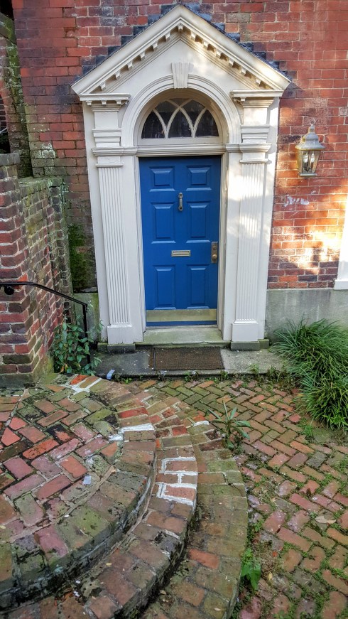
A short walk on a few streets of downtown Richmond on a hot July morning: LOVE these last two houses with their amazing entrances and windows: the latter one is the Crozet House, built in 1814.


Midsummer Mallows

I like several varieties of plants in the large mallow (malvaceae) family, most particularly the older common varieties rather than the showy hollyhocks and hibiscus which are really too big for my garden. There are musk mallows and malva sylvestris at the front of one border, but in the back is my very favorite: marsh mallow, or althaea officinalis. This is an old, fabled plant which is tall and velvety, with soft pink flowers, appearing just about now. Like all plants which officinalis status, marsh mallow was an important medicinal plant in the ancient, medieval, and early modern eras, the basis of soothing syrups and balms for throats, stomachs, skin–even teeth. The marsh mallow plant had edible uses in the past too: its sap was extracted and mixed with nuts and honey (and later sugar and corn syrup) to make a confection, and its root was boiled for use in both sweets and “sallets”. Modern marshmallows have no marsh mallow in them, but several “organic” skin creams do. I looked in vain through my sixteenth-sources for a sweet marsh mallow recipe, but found it as a principal ingredient in one of the recipes to cure lovesickness in Jacques Ferrand’s classic seventeenth-century treatise. So there you are: a plant that is both utilitarian and beautiful.

Mallow 3

Mallow 9

Mallow 1

Above: my marsh mallows. Below, hollyhocks in the Ropes Mansion Garden–I’m showing you close-ups rather than the entire plants because they seem to be stricken with some sort of rusty disease. My other mallows have this too–not very attractive–but the marsh mallows seem immune! 

Mallow 7

Mallow 6

Mallow 5

marsh-mallow Fidelia Bridges Prang

Salem-born Fidelia Bridges’ Marsh Mallows, produced for Prang in the 1880s, New York Public Library Digital Gallery.


The Salem “Heritage” Trail needs more…..Heritage

It is pretty well-known here in Salem that the Red Line that runs though downtown, the official “Heritage Trail”, is more representative of commerce than history. It encompasses heritage sites like the House of the Seven Gables, the Corwin (“Witch”) House and the Salem Maritime National Historic Site, but also more dubious enterprises like the Salem Witch Museum, the Salem Witch History Museum, and the Salem Witch Dungeon Museum, with no discernment. There are no standards along the Heritage Trail: the Peabody Essex Museum with its vast collections, blockbuster exhibitions, and professional staff and the Witch History Museum, a storefront shop which lacks collections, curators, and content, have equal status in terms of their roles as provisioners of “heritage”.  According to the American Alliance of Museums (AAM), a museum is a nonprofit institution, which maintains, interprets, and exhibits its collections for the public good. As Salem’s witch museums are for-profit enterprises, which maintain no collections and offer their performances and “exhibits’ exclusively for their private gain, I don’t think they qualify as museums under the professional definition: I prefer to refer to them as “experiences”.

Museum Collage A Tale of Two Museums; Alvin Fisher’s View of Salem from Gallows Hill, 1818, Peabody Essex Museum, and the Gallows Hill exhibit at the Witch History Museum (Of course now we know that the victims of 1692 were hanged at Procter’s Ledge rather than Gallows Hill).

Of course, people are free to choose whatever experiences they would like, but if tourists stick to the Red Line they are going to be missing out on much of Salem’s heritage. And they do stick to the Red Line, believe me: I followed several groups of tourists the other day (on the hottest day of the year) as they walked along it with great dedication, all the way from the Salem Witch Museum to the Salem Witch Dungeon Museum, bypassing several sites which are related to the real history of the Witch Trials: St. Peter’s Church, under which the body of Philip English lays, the Howard Street Cemetery, adjacent to where Giles Corey was pressed to death, the former sites of Bridget Bishop’s house and orchard, the Salem Jail and Court House where the accused witches were held and tried. The Salem Witch Dungeon Museum removed the plaque which marked the spot of the original jail and affixed it to their building, so now they “own” that history. The imprimatur of the Red Line makes it official.

lynde-street-076

Plaque on the Witch Dungeon Museum along the Red Line; the second, smaller plaque was added a decade later than the first.

The problem with the existing Red Line/Heritage Trail is not just its presentation of an incomplete and often-shoddy history of Salem. Because it is so obviously inadequate, it has led to a form of cultural “segregation”: other organizations, chiefly the National Park Service in collaboration with local groups, developed alternative walking trails to fill the gaps: architecture tours, a maritime tour, a tour featuring sites related to Salem’s African-American history, and a Hawthorne tour (you can download all the brochures here). There are also a wide range of commercial tours, which seem to have multiplied dramatically over the past few years. Visitors to Salem can have quite a different experiences depending on their degrees of preparation, resourcefulness, and curiosity. I also think that Salem’s reputation has suffered by comparison with the other Red Line (what I have often heard called the real Red Line), Boston’s Freedom Trail, which does not include commercial sites.

Salem has been a tourist destination for a long time, over a century, and we could learn from our past projections. The map included in my favorite old guidebook, What to see in Salem (1915) projects a route that is not dissimilar from today’s Heritage Trail in terms of geography, but exhibiting very different priorities: public places rather than private enterprises, an integrated city of real museums, sites associated with Hawthorne and the Revolutionary War as well as the Witch Trials, colonial and Federal houses and gardens. The problem with the 1915 route is immediately apparent, however, especially if you compare it with the current Heritage Trail map: no one stood to make any money.

What to see in Salem map 1915

What to see in Salem text 1915

Red Line Map 2016

Map and Key from What to see in Salem (1915) and current Heritage Trail Map, available here–all the numbers refer to local businesses and the museums, real and faux, are in text. Judging by font size, the Gallows Hill Museum/Theatre looks like the place to go! (But it’s never open, except in October).


More Harmonious Hamptons

There are no flourishes or deep dives in today’s post; I’m simply offering up some alternatives to the new Hampton Inn that will open in a dreadful building to be built at the southern end of Washington Street in Salem, in a thoroughly commercial zone. There’s no preservation issue here–this building will replace a rather dilapidated one-story commercial strip built in the twentieth century–but there are “suitability” questions, which the general public never seems to have the opportunity to weigh in on: of size, scale, use, design. This is the latest in a series of big boxy buildings built in downtown Salem that are transforming its architectural character in a rather alarming manner.

Hampton Inn Salem MA

Dodge Street Hotel Salem News 2014

Rendering and model of the recently-approved  five-story, 178,000-square- foot, $50 million-dollar building-complex to be built on an entire city block between Washington and Dodge Streets and Dodge Street Court in Salem, Salem News.

The Hampton Inn will comprise only part of this monstrous complex, which is being developed by RCG, a real estate development company headquartered in Somerville, MA which has an ever-increasing profile in Salem. The generically ghastly Tavern in the Square building (which everyone refers to as the TITS building), located just a few yards down Washington Street from the Hampton Inn site, is proudly posted on their corporate website, and indeed the first design for the latter looked very much like the former. Apparently it was “improved” in the planning and design review process, so it is “better” now, both “better” than what was there before and better than the original design. The potential economic benefits of this project are considerable, so its design is a secondary (tertiary? inconsequential?) consideration: it is “better” so it will be built. As I indicated above, the Hampton Inn is only one component of this project, but that is the component which can offer some comparisons, so I went searching for some. There’s been some criticism of a chain hotel coming to Salem, but I don’t share that view: I think we are losing out to the chains proximate to Route 128 if we don’t have something comparable in our city. But we don’t need to accept a standardized design: it seems clear to me that Hilton Worldwide will conform to local settings for their Hampton Inns (actually now I think they are called Hampton by Hilton) brand, but apparently setting is not a consideration in Salem.

A subjectively-selected showcase of urban Hampton Inns: first new construction, then adaptive reuse, which is not an option for the Salem site.

hampton-inn-suites-savannah

Hampton Inn Savannah Savannah

Hampton Inn Alex VA Alexandria, Virginia

hampton-inn-new-orleans-st-charles-ave-garden-district-hotel-front New Orleans/Garden District

Hampton Inn Baltimore Baltimore

Adaptive reuse:

Hampton Inn Providence downtown Providence

Hampton_by_Hilton_Kansas_City_Downtown_Financial_District_Exterior_HR Kansas City

Hampton Inn Ogden Ogden, Utah

Hampton Inn Cincinnatti Cincinnati


Anatomy of a Restoration

The new owners of a beautiful Chestnut Street townhouse, part of the street’s only triple house which also happens to be its tallest structure, very kindly allowed me to come in and take some pictures of their restoration process, which has begun in earnest. I’m so grateful, because this was the perfect time: the bones of the house were exposed in all of their beauty–and strength. Even with ceilings torn out and dust everywhere, the building still looked elegant–and solid–from top to bottom (well maybe the basement isn’t beautiful, but it sure is interesting, as you can see below). This is a very notable house not only because it is a “triplet”, but also because it was home to three Salem mayors, including the Reverend Charles Wentworth Upham, who was also President of the Massachusetts Senate, a U.S. representative, and author of Salem Witchcraft; with an account of Salem Village, a history of opinions on witchcraft and kindred subjects (1867). The entire house was commissioned by Salem shipowner Pickering Dodge, who lived next door, in 1828, ostensibly for several of his five daughters. A son-in-law, John Fiske Allen, oversaw the completion of the project after Dodge’s death in 1833 and his widow lived in the westernmost townhouse—our townhouse–until her death in 1851, followed by all those mayors in the nineteenth century and one of Salem’s most prominent preservationists in the twentieth. The restoration philosophy is conservative: reveal and burnish what is already there, and alter the systems and utilitarian rooms of the house (kitchen and bathrooms) so that they can “be useful to the daily lives of today” in the words of project architect Helen Sides: “Kitchens are no longer for servants and it’s nice not to share the bathroom if there are spaces to put new ones!  It is the responsible thing to update these houses so that they can stand for another 200 years”.

Restoration Cousins 1916

Chestnut Street Salem 2016

Looking up Chestnut Street towards the triple house, 1916 (Frank Cousins) and 2016.

Restoration 5

Restoration 6

Restoration 7

Entrance hall and front and back stairs. This house has a lovely scale and great light (even though it has a firewall on one side) because it is two rooms deep–so you have windows both in the front and the back. Because it also has both front and back stairs I imagine it has great flow too…and the basement is a virtual museum.

Restoration 10

Restoration 12

Restoration Collage Slatted Cupboards

Original basement kitchen, coal bin, and pantry with “slatted cupboards”—I’m not sure that’s what they are called, but I have the EXACT same ones in my house, built roughly at the same time (on the left with reindeer, swan, and pinecones: this is my seasonal decoration room). Back upstairs…..

Restoration 15

Restoration 21

Restoration 3rd floor

Restoration 4th floor

Bedrooms on the second, third, and fourth floors. The windows have their own dedicated restorer, Window Woman of New England, who have developed quite a reputation here in Salem. A very conspicuous aspect of this house is its built-in cupboards, cases, cabinets and closets–very evident in the second-floor study but also all throughout the house.

Restoration 16

Restoration Collage Cupboards

Restoration 8

A collage of cupboards between the bookcases of the second floor study and the first floor butler’s pantry (?) cabinets, which are PERFECT. I always notice COLOR in older houses—tones you don’t normally see–but in this house (in this state) it was really more about the color of wood, briefly exposed before new ceilings are installed.

Restoration Collage

Restoration Ceiling

Restoration boards

Restoration boards 2

Restoration Tim

Love the red stairway (down to the basement) and green doors…various exposed ceilings…Tim of Peter Strout Construction building a new bathroom in this old house……out back: another house!

Restoration 22

Restoration Sink.jpg

Restoration 24

Set in the midst of the long garden out back is a carriage house  (according to Bryant Tolles’ Architecture in Salem) which was converted to a residence c. 1912 utilizing materials from the demolished Chase house at 21 Federal Street. Obviously there was a deep appreciation for Salem craftsmanship then, which is very much in evidence here and now.

Restoration Team Collage


Yellow Houses of Nahant

When I met my husband he was living in Nahant, a “land-tied island” (two actually) to the south, between Salem and Boston. It’s one of the smallest towns (if not the smallest) in Massachusetts, a single square mile in size with less than 4000 inhabitants. I spent quite a bit of time there while we were dating, and when we decided to get married there was a bit of a tussle which Salem (and I) won. I think this was the right decision for us as a couple, and certainly for his architectural practice, but I do wonder occasionally what our lives would be like if we decided to live in Nahant rather than Salem. And of course, I picked out all of my (our) potential residences during the time I spent there–something I do in pretty much every town in which I spend more than a few hours. The other day while I was driving by the causeway that leads out to “the island” I decided to revisit these houses. Nahant has some amazing coastal properties, but only one is on my list–all the others are on or just off the main road that runs through the center of the town. It was only when I returned home and looked at all the pictures that I realized all of my favorite Nahant houses are yellow.

Nahant PO

I always loved the Nahant Post Office…..below, “my” houses: the first one overlooks Egg Rock (which never seems to stay in the same place!) and is very difficult to photograph so you’re not really seeing its entirety or its details. The rest are easier to capture…even the long double Whitney house, once an inn and tavern, which is the oldest structure in Nahant. The last house–a Gothic Revival cottage near the library–is my very favorite: if my future husband had owned it we probably have wound up in Nahant!

Nahant 3

Nahant 5

Nahant Egg Rock

Nahant 7

Nahant 9

Nahant 11

Nahant 10

Nahant 1

Save

Save

Save

Save

Save


Rededicating Derby Square

Salem has quite a few intersections named “squares” but very few square squares. Its most conspicuous one is Derby Square, which was carved out of the growing city 200 years ago. This month’s Derby Square FLEA Salvage ART Market, coming up tomorrow, is marking the Square’s Bicentennial with a special theme and ribbon-cutting, and so I thought I’d examine this early example of urban planning in Salem. The basic background is well-known: John Derby III and Benjamin Pickman, Jr., scions of wealthy Salem families, business partners and brothers-in-law, offered the land on which the majestic and short-lived Derby Mansion formerly stood to the town of Salem in 1816 with the provision that a suitable civic building be built–civic in this context clearly implying both public and commercial functions. The city accepted the offer, and so the new Derby Square was developed over 1816-1817 with the new Town Hall/Market House at its center. It is clearly visible on Jonathan Saunders’ 1820 Plan of the town of Salem in the commonwealth of Massachusetts, from actual surveys, made in the years 1796 & 1804; with the improvements and alterations since that period as surveyed, marked as the #1 improvement and/or alteration to the town.

1820 Map of Salem BPL

Jonathan Peel Saunders, Plan of the town of Salem in the commonwealth of Massachusetts, from actual surveys, made in the years 1796 & 1804; with improvements and alterations since that period surveyed, 1820. Leventhal Map Center, Boston Public Library.

In the tradition of both European cities from the late medieval period onward and urban centers in colonial America, the centerpiece of Derby Square was designed to be a combination town hall and market, with an open arcade on the ground floor and meeting space on the second. Boston’s Faneuil Hall and Old State House had similar dual–even multiple–functions, as had Salem’s first town hall, built in 1636. There does not seem to be agreement on just who was the architect of the new town hall, although Bulfinch is mentioned in some sources, but Joshua Upham built the structure at a cost of $12,000. The lower story opened in late fall of 1816 and the second story was “christened” by visiting President James Monroe on July 8, 1817. The new Town Hall served in that capacity for only 20 years, and became the Old Town Hall with the construction of the Greek Revival structure on Washington Street in 1837-38; thereafter it was principally known as the “Market House”. Derby and Pickman had a vision that extended beyond just one building however, however: they determined the structure, scale, and composition of Derby Square by building several buildings surrounding Old Town Hall themselves and selling adjacent lots with deed restrictions specifying brick or stone construction. This was waterfront property in the early eighteenth century, and Derby and Pickman also donated a way to the water to the town of Salem with the condition that it remain a fish market in perpetuity: the “Derby Deed” lost some of its restrictive strength over the years, resulting in a Salem Marketplace that offers more than fish.

There are a lot of images of Derby Square out there, so I went to the Salem State University Archives and Special Collections to see if I could find some views that were a bit more fresh. Among the stereoviews, ephemera, and pamphlets of the Dionne collection I was able to find quite a few Derby Square-related materials–if I had more time to spend in the victualler records, I doubtless could have found much more. Clearly Market Square/Derby Square operated as a seasonal and regional food market over much of the nineteenth and twentieth centuries, just as it does now on the summer Thursdays of the Salem Farmers’ Market.

Derby Square Stereo Procter Crop

Derby Square Winter Procter

Derby Square Stereo Moulton

Derby Square Stereoview Moulton crop

Two G.K Procter stereoviews of Derby or Market Square, summer and winter (cropped in half), c. 1861-1882; and two stereoviews of the Square by J.W. and J.S. Moulton Photographers of Salem, who operated from 1873-1881, all from Nelson Dionne Collection of Salem Images at Salem State University Archives and Special Collections. Below: a few billheads, also from the Dionne collection, which represent the dominance of the victualling trade in the Market and the inconsistent use of “Derby Square” and “Market Square”.

Derby Square Billhead

Derby Square billhead 1885

And from a private collection, here is an undated photograph of the Square which is quite unusual in its relative emptiness–it was among some Frank Cousins photographs so it could be one of his, but I just don’t know. In any case, I love it!

Derby Square nd

How has Derby Square fared in the age of the automobile? The visual evidence indicates that its integrity was challenged in the third quarter of the twentieth century, given its location in the center of the urban renewal storm. Yet this same (central) location, combined with its classical design and steadfast (central) function, determined that it would not only survive but also stand as a symbol of Salem’s revived prosperity.

Derby Square 1960s SSU

Derby Square Salem Marketplace SSU

Derby Square and Salem Marketplace in the 1960s and 1970s: how horrified John Derby III and Benjamin Pickman Jr., would have been by the Budweiser sign! Below: more sentimental views from early and late twentieth-century postcards.

Derby Square PC SSU2

Derby Square PC 1913 SSU

Derby Square PC Higginson SSU

Save

Save

Save


Felines in Frames

In GREAT anticipation of my visit to the Worcester Art Museum in order to see their big summer show, Meow: A CatInspired Exhibition (featuring cats-in-residence!) I have curated my own little digital exhibition, as I have a very large (digital) folder full of cat paintings.I could feature fifty paintings here, but I have restricted myself to seven, ok maybe nine. In chronological order, with commentary:

girl-with-garland_large

Cats HenryWriothesley

Hans Süss von Kulmbach (German, Kulmbach ca. 14801522 Nuremberg), Girl Making a Garland, c. 1508, Metropolitan Museum of Art, New York; John de Critz, the “Tower” Portrait of Henry Wriothesley, 3rd Earl of Southampton, imprisoned following the Essex Rebellion in 1601 with his cat Trixie. Buccleauch Collection, Boughton House.

Here we have enclosed portraits of remembrance and appeal: Southampton wants to get out of the Tower, and ultimately King James will release him. Cats are not pets in the pre-modern era, so typically they are depicted in the background, disassociated from humans and being cats: eyeing something to eat, chasing something, lying about. But here we have some very close-up, still, companion cats: unusual. The Southampton portrait and the significance of the cat has been dissected many, many times: my favorite analysis is here.

van Hoogstraten, Samuel, 1627-1678; A View through a House

(c) National Trust, Fenton House; Supplied by The Public Catalogue Foundation

A Sleeping Cat circa 1796-7 by Joseph Mallord William Turner 1775-1851

The nineteenth century is the golden age of cat paintings: cats move into the foreground, and even displace dogs in domestic settings (I think; but I could be biased). Certainly the American folk artists of the first half of the century loved cats–they are nearly omnipresent in the works of Zedidiah Belknap and Joseph H. Davis. Not only are they a fixture in the home, but also a subject of serious scrutiny, even preoccupation: so many Steinlen cats. I’m finishing up with another artist’s cat, featured in Eric Ravilious’s study of Edward Bawden in his Studio, from 1930. This is not the most aesthetically pleasing depiction of a cat, perhaps, but as every cat owner (companion? host? feeder?) knows, it is a very characteristic one.

Save

Save

Save

Save


Marked by a Witch

I have featured maps on this blog many times: maps allegorical, anthropomorphic, and antique, maps featuring octopuses, spiders, relationships and myriad places and perspectives. An ongoing exhibition of pictorial maps at the University of Southern Maine’s Osher Map Library has inspired me to examine this particular cartographical creation yet again–along with a recent ebay score of one of my favorite local pictorial maps, Alva Scott Garfield’s “Scott-Map of Salem, Massachusetts”. Maps with pictographic elements go way back, but the Osher exhibition is focused on the mid-twentieth century, identified as “The Golden Age of American Pictorial Maps”. I wanted to confirm this chronology in my own mind, so I began perusing the larger collection of pictorial maps at the David Rumsey Map Collection: casual browsing led me down the virtual rabbit hole, of course!  Clearly you can map anything in a pictorial way: plants, animals, commodities, imaginary places, infrastructure and material culture, the past and the present: one of the major reasons the Osher exhibition identifies the mid-twentieth century as a golden age for these maps is the production of so many maps related to the campaigns of World War II, and these are among the most striking maps of this genre. I love global and national pictorial maps (a particular favorite is pictorial-map pioneer MacDonald Gill’s “Tea Revives the World”, produced in the darkest days of Britain’s World War II experience and pictured below), but the more I looked at the Osher and Rumsey maps and my newly-acquired ScottMap of Salem the more parochial my perspective became. Since the golden age of pictorial maps was roughly coincidental with the Salem’s increasing identification as the Witch City, I wondered if this would be apparent on regional and local maps. How often did a witch mark Salem’s place on the map?

Tea-Revives-the-World-Gill

Pictorial Map America 1940 Osher

Two Patriotic Maps from 1940: “Tea Revives the World” by MacDonald Gill and “America–A Nation of One People from Many Countries”, published by the Council Against Intolerance in America, Rumsey Map Collection and Osher Map Library.

Quite often, it seems, though the struggle between Salem’s divergent commercial and cultural identities is also evident on local pictorial maps from the mid-twentieth century. Situated between the big shoe representing Lynn’s characteristic industry to the south and the fishermen of Cape Ann to the north, Salem is represented alternatively by either the House of the Seven Gables or a broom-mounted witch, and sometimes both. Coulton Waugh’s beautiful map of “Cape Ann and the North Shore” (1927) identifies Salem with the Gables and the famous ship Hazard, but over the next several years the witch appears on Griswold Tyng’s illustrated Map of the Eastern United States (1929), Harold Haven Brown’s Picture Map of Massachusetts (1930) and Elizabeth Shurtleff’s very detailed map of Massachusetts, “the Old Bay State” (1930). One of my very favorite pictorial maps, Raymond Lufkin’s “Old Massachusetts” produced for The House Beautiful in 1930, is focused on the state’s architectural heritage, so witchcraft is literally marginalized (along with another notable event in Salem’s history, the landing of the first elephant in North America). Surprisingly there is no witch on Paul Spener Johst’s 1931 picture map of Massachusetts (just a BIG pilgrim), but the increasingly-familiar figure returns on Elmer and Berta Hader’s cartoon map of Massachusetts published in 1932, from their Picture Book of the States. From that point on, the flying witch marks the spot of Salem on most pictorial maps. By the time we get to the end of the “golden era”, Salem is firmly established as the Witch City on Ernest Dudley Chase’s official travel map of Historic Massachusetts, and the “Scott-Map of Salem” can make the rather whimsical claim that “aviation started in Salem”.

Pictorial Map North Shore 1927 Osher

Pictorial Map US Tyng 1929 Rumsey Map Collection

Pictorial Map Massachusetts Brown 1930

Pictorial Map Shutleff 1930

Pictorial Maps House Beautiful 1930

Pictorial Maps House Beautiful detail Salem 1930

Pictorial Map Massachusetts Johst 1931

Pictorial Map Haders 1932 Rumsey Map Collection

How Salem is marked on the map, 1920s-1960s: ABOVE: Coulton Waugh’s map, 1927; details of Tyng US Pictorial map, 1929, Brown “Picture Map“, 1930, and Shurtleff map, 1930; “Old Massachusetts” published by The House Beautiful, 1930; Johst map of Massachusetts, 1931; Hader pictorial map of Massachusetts, 1932; BELOW:  Ernest Dudley Chase’s Historic Massachusetts, “A Travel Map to help you feel at home in the Bay State”, 1957 (published by the Massachusetts Department of Commerce) and Alva Scott-Garfield’s “Scott-Map of Salem, Masschusetts”, 1960.

Pictorial Map Mass 1957 Chase

Pictorial Map Scott-Salem 1960

Save

Save

Save

Save

Save


Queen of the Garden

My garden is peaking now: next week I will shear off flowers and get another full-flowering in late August or early September. In between a few flowers will light up the back but it will mostly be a sea of green. This is fine with me; I have chosen plants as much for their leaves as their flowers. In my little garden, Midsummer is signaled by the flowering of meadowsweet, one of my very favorite perennials. I have a double-blooming variety (Filipendula vulgaris ‘Flore Plena’) which I purchased from Perennial Pleasures up in northern Vermont long ago: it is very dependable and very showy, and probably much too big for my small garden. Meadowsweet is commonly referred to as the “Queen of the Meadow” (in its native Europe) or the  “Queen of the Prairie” (in the U.S.) but I think of it as the Queen of my garden! Like most of my plants, it is more of an ancient wild flower than a proper “Garden Flower” (determined, like most things, by the Victorians I believe): if a plant does not have a proper medieval “wort” name and quasi-mythological medicinal heritage, it doesn’t find its way into my garden. Meadowsweet was alternatively known as dropwort, bridewort, and meadwort in the pre-modern past, and was used as a strewing and flavoring herb, as well as a painkiller and digestive. In the nineteenth century, salicylic acid was isolated from meadowsweet, a key event in the development of aspirin, which was named after the plant’s previous Latin name, Spiraea ulmaria. Though not named as one of the nine sacred herbs in the Anglo-Saxon Lacnuga (“Remedies”) manuscript, this particular Queen has ruled for quite some time.

July 2016 garden: I’ll let my cat Trinity lead us to the Meadowsweet in a meandering way.

Queen of the Garden 7.jpg

Queen of the Garden 9

Queen of the Garden photo.jpg

Queen of the Garden 11.jpg

Queen of the Garden 6

Queen of the Garden.jpg

Queen of the Garden 5

Queen of the Garden 4

I love my lungworts–another important medieval plant that looks lovely from May through September. Trinity wasn’t really interested in the meadowsweet, but here they are, for several different angles: I would love to see a prairie/meadow full!

Queen of the Garden 2

Queen of the Garden 3

Queen of the Garden 10


%d bloggers like this: