Tag Archives: urban planning

Fall Reading 2025

The stars seem to have aligned and I am all set for a fall full of reading. Salem’s Centuries is in production (and out on January 6), my new saffron project hasn’t taken flight yet, and I have a course release for the semester. I’ve written two books in five years and now is the time to ingest. Escaping into book worlds is another way of avoiding my least favorite season in Salem as well. So I have a long list, already about a quarter devoured. As usual with my book lists, it’s very light on fiction, heavy on history, and reflective of the odd ephemeral interest. So let’s go: it will be interesting to see how I group these rather disparate texts.

I think I’ll start out with broad, cultural histories as they might have the most general appeal: I’m always reading “commodity histories” and this year will be no exception, but I have to tell you that Robert Hellyer’s Green with Milk and Sugar has a bit more depth and dimension than most books about tea—and there are a lot of books about this particular commodity. I had the difference between black and green teas down, but did not discern between different types of the latter (and their impact) until I read this very interesting book. Another important global commodity, sugar, has also received quite a bit of attention from scholars (beginning with Sidney Mintz’s classic Sweetness and Power) but the latest effort, the Dutch economic historian Ulbe Bosma’s World of Sugar, is supposed to be particularly comprehensive. I bought it last year but haven’t delved into it yet. Super excited to read Catland: how can it not be amazing? I’m not sure where to put Chanterelle Dreams, Amanita Nightmares, a book I discovered in the gift shop of the Coastal Maine Botanical Garden a few weeks ago solely for its title (+ lore), in this post so I guess I’ll put it here: it is kind of a broad cultural history of human perceptions of muchrooms. It’s also very much a “pick up and read a bit” book.

I find that I am reading new books on the Atlantic Slave Trade regularly because we are in the midst of a golden age of research into the history of this terrible trade and provocative analyses of its cascading impacts are published every year.  Traders in Men and Plantation Goods are on my fall list but I should have read them this summer, in advance of teaching my Introduction to European History course. Instead, I had a “Roman interlude” prompted by a re-reading of Suetonius’s Twelve Ceasars last spring. So two half-read Roman books are on my fall list too: a very accessible history by Anthony Barrett about Emperor Nero and the burning of Rome and a book by Roland Mayer about Roman ruins which is more about later perceptions of Rome than Rome itself. The Mayer book probably belongs with the broad cultural history books above. I have started Traders in Men and Plantation Goods (as you will discern by now, I read books in phases, concurrently with other books, a habit I’ve been trying to break but cannot) and my assessment so far would be: both very important and well-sourced studies, with Plantation Goods probably more accessible as it focuses on the basic. It is very much a “material history.”

There are several books which were recently published in my scholarly fields which now sit beside my bed in a stack: first up is Inventing the Renaissance and then we have two books on major late Tudor/Jacobean players: George Villiers, the Duke of Buckingham, and Robert Cecil. I’ll read these for myself, but also to discern whether or not I’ll assign them to students. Stephen Alford (author of All His Spies)’s previous book, London’s Triumph, was a big hit among my grad students this past summer. I suspect that Palmer’s Inventing the Renaissance will be great for historiographical discussions in both undergrad and grad courses. And because it was set in my period and in an interesting period in Mary, Queen of Scots’ life, I actually read a novel all the way through this summer: Flora Carr’s The Tower.

Finally, books on more topical interests which are preoccuping me constantly and/or currently. I’m always interested in architecture, and I read one book this summer which I loved: Thomas Heatherwick’s Humanise (it’s spelled Humanize in its American edition but I prefer the British one’s cover). I don’t think many architects like this book as it is quite critical of contemporary architecture not so much on the basis of design but of craftsmanship. Heatherwick has provoked a reaction among architects in the UK (I’m not sure about here) as he is not an architect himself and does not hold back on characterizing much present-day building as both soul-crushing and soulless (generally because it is so boring) and has launched a campaign to bring joy and craftsmanship back to construction. He’s a real crusader! I’ve been interested in the urban planning idea of the “15-minute city” for a while, so I picked up Shrink the City to learn more about it. The whole idea of meeting all your needs within a 15-minute radius could work for a city with the infrastructure of Salem, but not if we continue our comprehensive commitment to witchcraft tourism, which has resulted in a multitude of witch shops replacing those selling clothing and groceries. As this past year I seem to have become preoccupied with symbols and emblems, first because of the ongoing discussion over the Salem city seal and more recently by the dumbing-down of the Massachusetts state seal and flag, I’ve really been searching more insights into visual culture and graphic design. It’s like another language which I don’t understand. One book that has really helped me is the classic Megg’s History of Graphic Design, but I welcome suggestions. I have yet to find a thoughtful or even interesting book on vexillology.


Two Visions for Salem

I’m in the history business, so I rarely dwell on visions, unless they are in the rear-view mirror. But last week I happened to take two photographs while running around in downtown Salem, and when I looked at them later on my phone I realized that they represented two visions for Salem, at least to me. Here they are and then I’ll explain.

The first (top) one is a photograph of recent changes to Washington Street, the key north-south corridor in downtown Salem forever. Vehicle traffic has been limited to just one lane now, with parking alongside and an expanded sidewalk and hot-top bikelane. The present administration LOVES bike lanes and wants to install as many as possible anywhere and everywhere, even in this case at the expense of safety (how can an ambulance or fire truck possibly get through with one lane, especially during peak tourist time?), aesthetics, and congestion (look at all that parallel parking—that takes time–even for those who know how to do it!)

The second (bottom) photograph shows Salem’s 157th t-shirt shop, now installed in a very prominent building on the corner of Essex and North Streets, just across from the Witch/Corwin House. Just rows and rows and rows of t-shirts.

For me, the first photograph represents the City’s attempt to take back territory ceded to cars over the past century or so, in terms of both parking and driving. This is certainly a laudable goal with which I have no problem (except with the implementation—there’s just too much ugly concrete going in downtown in my opinion) but I think a corollary of that vision is one of a “15-minute city” in which residents can obtain all essential goods and services within a 15-minute walk or bike ride in any direction.The 15-minute city concept has been popular among planning professionals for the last decade after being introduced by Carlos Moreno, an urban studies and business professor at IAE Paris – Panthéon Sorbonne University. I actually think that Salem could be a 15-minute city, BECAUSE IT WAS, but not now—as that goal is completely incompatible with its current status as mecca for witchcraft tourism. I’m sorry, but I don’t think droopy or pointy witch hats are an essential good, nor palm readings an essential service. I live in downtown Salem, or right on the edge of it, and I know that I must drive to purchase shoes or go to the dry cleaner or the doctor. I’m not sure the concept of the 15-minute city is compatible with any city centered on tourism, unless it’s a big city, like Paris. But smaller cities have to make a choice, and to me, it seems like Salem has chosen tourists over residents. As evidence of that choice let me offer up another photograph that I took this past week, of the bump-out and bollards in front of the Ropes Mansion. Because of Hocus Pocus rather than history, this historic house is a popular walking tour and selfie destination, and unfortunately a car-on-pedestrian accident happened a few years ago. To accomodate and protect the crowds, the city expanded the sidewalk and installed many shiny black bollards, just another example of how Salem’s streetscape is being shaped not by the rhythms of daily life for its residents, but the demands of larger and larger crowds of tourists.

I’ve been thinking about the 15-minute city concept for quite a while, after discovering (actually being shown) an amazing map of downtown Salem in 1946 at the Salem State Archives and Special Collections. It’s a real estate map with a focus on businesses, incredibly detailed and revealing very clearly a 15-minute city in which everyone could buy or do anything within that radius. The variety of shops was just amazing: just place little witch hats on one part of one street on the sites of buildings  that were formerly shoe shops, druggists, stores selling fruit, paint, rubber, hats, and draperies, dry cleaners, and “Topsy’s Chicken Coop,” and you have the visual history in a nutshell. The SSU Archives has tons of busy street scenes on their Flickr page but I thought I would feature some more focused street scenes from a newish and loose collection of “Salem Streets” images from the Phillips Library as I have become enraptured by them! So yes, even though I started and titled this post with “visions,” I have reverted to form and am looking back. I just can’t help it: the future is a bit scary.

The incredibly detailed Nirenstein Realty Map of the “Business Section of Salem,” 1946, Salem State Archives and Special Collections and Dockham’s Salem Business Chart, n.d., Phillips Library Broadsides, above.

Views of Central Street, 1880s-1932, from the Phillips Library Salem Streets collection:

Brown Street, c. 1910, Phillips Library Salem Streets Collection.

A very old shop on Mill Hill (Washington Street) before the Great Salem Fire of 1914, Phillips Library Salem Streets collection.

And the cutest cobbler shop ever on Broad Street (of course there was no comprehensive zoning before the 1930s either—so the home/work/shopping radius could be very small indeed). Phillips Library Digital Collections.


Norman Street Will Break Your Heart

Norman Street has been an important street in Salem for centuries, serving as an east-west way first to the harbor, then to the train station, and linking downtown and the city’s west-lying residential neighborhoods. It was once tree-lined, along with Georgian colonial houses interspersed with shops. It had a bit of a reputation as an American “Harley Street,” with several prominent physicians in residence, and it even has an eerie element, referenced by an entry in Nathaniel Hawthorne’s notebook for 1839 in which he recounts a story told to him by Custom House inspector William Pike, who “Another time — or, as I think, two or three other times — saw the figure of a man standing motionless for half an hour in Norman street, where the headless ghost is said to walk.” Norman street was also Samuel McIntire-central: Fiske Kimball asserted that the great architect and woodcarver was born at #21, and both his father and brother lived (and worked) on the street. Despite its heritage, and because of its continuous role as a central corridor, Norman Street was very vulnerable to one of the most dominant forces of the twentieth century: the car. From about 1930, it was transformed from a human-scaled city street into a wide suburban “connector,” a process that was intensified with the construction of two large buildings at its eastern and western ends, a new U.S. Post Office building and the headquarters for the Holyoke Mutual Fire Insurance Company. These buildings wiped out more than 50 residences on their side of the street and adjacent streets, even more after the Holyoke building’s expansion in the 1970s. On the north side of Norman, the New England Telephone Company initiated a similar cascade of demolition commencing several decades earlier. Business and residency had co-existed on Norman Street since Salem’s founding, but these larger businesses brought more workers and more traffic. The street was widened considerably, causing it to lose much of its residential charm, and one by one the remaining colonial houses fell, along with all of its trees. There is no question that the car was the major culprit in this unfortunate transformation, but Norman Street is also a study in how little control a municipality has over urban development if it does not have robust planning tools in place, or if it chooses not to utilize those tools.  When I look at Norman Street today it appears that the City of Salem seems to have essentially written it off, leaving it to landlords and speeding cars. If you’re a preservationist or a pedestrian, Norman Street will break your heart, especially if you know what was there before.

Norman Street past.

Looking down (east) Norman Street in the 1880s and 1910s, Lee MSS & Frank Cousins slide, Phillips Library, Peabody Essex Museum; the Cox House, 1890s, Dionne Collection, Salem State University Archives & Special Collections. EIGHT LARGE BRICK OVEN FIREPLACES in the Felt House, an “antiquarian’s delight.” Looking west towards Chestnut Street, Lee MSS, Phillips Library and “Newsboys” at the corner of Washington and Norman Streets, c. 1910, Salem State University Archives & Special Collections. The very famous Mansfield House with its carved stair and mantel, Cousins photos and Boston Architectural College Yearbook for 1925; wallpaper from Dr. Cook’s famous house on Norman Street, the Magazine Antiques, June 1925; Postcard of the new Holyoke Mutual Fire Insurance Company headquarters at the corner of Summer and Norman Streets, 1936, SSU Archives & Special Collections; the Texaco station across the street, 1979, MACRIS; New condos at the northeastern end of Norman Street, 1982, Boston Globe and SSU Archives & Special Collections.

The last two photos of condo conversion and construction in the 1980s represent a positive change for Norman Street: the return of residents! The business blocks and setbacks, along with the widening of the street, have certainly left their mark, however, as you can see from the photographs below which I took this weekend. It’s hard to recognize this once charming street. A couple of years ago, I kind of got my hopes up for Norman, and that’s why heartbreak is in my title (and also the description of the Felt House above). Responding to the crush of traffic at the terrible intersection of Norman and Summer, the City installed a mini roundabout, and I thought this might be the start of a concerted effort to recognize the street as a proper entrance corridor, but no, it’s just a circle of fake brick in the middle of the road. Drivers still get so frustrated by this intersection that they tend to speed up before and after, which is why I’m always anxious about crossing Norman Street. Bordering this circle are beautiful Chestnut Street houses on the west side and the hulking former Holyoke building  and an 18th century house with a strident 21st century addition on the east: this space sends a mixed message! Last summer, the weeds surrounding the Holyoke building reached up to its lower windows, and signs and litter are always strewn about. Its owner has had difficulty finding commercial tenants, and so part of the building (I think the original 1930s building) will now be consigned to a homeless center for families operated by Centerboard, the largest housing provider in Massachusetts. A proposed new housing development for the Texaco site across the street has just been granted significant tax credits by the Commonwealth, and so will now go forward. At the very least, this project (you can see a rendering here, but it’s from a couple of years ago) should eliminate that hole along the streetscape, but I hope the design does more than that. In fact, I think that this new building is Norman Street’s only hope.

Norman Street present.


It would be nice if that “Caution X-Walk Ahead” sign was positioned towards drivers in the street rather than pedestrians on the sidewalk.


Olmsted Central

I have felt vulnerable all summer long, while working on my contributions for our Salem book: my chapters relate to academic fields for which I have no professional preparation, including African-American history (John Remond), art history (the Colonial Revival) and urban planning (Salem’s 20th-century development). I read widely and had support from my colleagues, and all the chapters will be peer-reviewed, so I don’t think I’ll embarass myself in the end, but I’m still a bit anxious. I’m co-writing the last referenced chapter, on Salem’s development from the Great Salem Fire of 1914 to the present, with my co-editor for the entire book, and after I plowed through rebuilding and urban renewal I simply dumped it on him, just done with it! It wasn’t fun to write and I needed some distance to reflect. So that’s what I have been doing for the last two weeks or so, trying to read histories of urban planning for pleasure. This is a field that intersects with the history of landscape design and garden history—and as the latter is more familiar to me I found a comfort zone. So I got some grounding and feel ready to go back into this chapter with some different perspectives and questions. I also realized I needed to cap off my weeks of reading with a visit to what must be the Mecca of landscape history: the Frederick Law Olmsted National Historic Site in Brookline, Massachusetts.

So Chestnut Hill, a beautiful section of Brookline which extends over into Newton, was my weekend destination. This is where Boston Brahmins established their country seats in the later nineteenth century, and because of these considerable investments in land the area still retains its pastoral feel despite its proximity to Boston. At the height of his pathfinding career in 1883, Frederick Law Olmsted purchased an early 19th century farmhouse and several acres of land from two elderly spinster sisters who were reluctant to move: he built them a house next door. Another neighbor was Isabella Stewart Gardner, whose “Green Hill” summer house was built by Salem ship captain Nathaniel Ingersoll earlier in the century. Olmsted did not intend for his new house, named Fairsted, to be a seasonal showplace: it became the center of his business and his practice, as well as a center for the emerging new discipline of landscape architecture. This is the focus of the site’s interpretation: on the practice rather than the personal. The farmhouse was expanded in all directions, most conpicuously in the office addition which served as the headquarters of the Olmstead Brothers after the Frederick Law’s retirement in 1895. The firm endured (as the Olmsted Associates) until 1980, the same year that the National Park Service acquired Fairsted. As you can see from the photographs above, the orginal farmhouse its garden addition are not in the best shape: a planned and funded restoration has stalled due to the quality of the workmanship, and is delayed until the next funding process (but private donations can be made here). The interior of the farmhouse is pristine, and (again) dedicated to telling the story of the Olmsted practice. The office addition is like a time capsule of a 1920s-1930s architecture firm: with a drafting room, a photography room, a blueprint-printing room, a shipping room, and a vault, where all the Olmsted plans are archived.

In the main house: very few personal items, it’s all about the firm. I was primarily interested in the urban planning inititatives of the Olmstead firm as my chapter on Salem’s 20th century development begins with Harlan Kelsey’s 1912 City Plans Commission report. Because the Olmsted projects are so extensive, both in sheer number and geographically, the firm’s archives are always in demand and consequently the NPS has completed a major digitization project and also furnished researchers with an invaluable research guide to the collections. I found five Salem projects, the most important of which is the subdivision of the famous Pickman/Loring farm c. 1900: this was Salem’s first planned neighborhood, and I didn’t include it in my draft chapter (but I’m certainly going to do so now)!

The Olmsted site offers two tours, both of which were given by enthusiastic and articulate interns: one on the cultural landscape, the other on the office and practice. In the first, we learned all about Olmsted’s design philosophy (naturalistic and anti-Victorian, not particulaly interested in PLANTS, “borrowed view”) and the second focused primarily on how the firm was run during the era of the Olmsted sons/brothers. I just loved the office tour: forget AI and digital “reality”: this was immersion!

The Olmsted office wing: photography library with project #s (all materials are preserved in the vault now), drafting room, planting specifications, blueprint-printing room (and a very strange blueprint drying machine), shipping room, little cubbyhole office outside the vault.


Preservation Polaroids

I have heard, and read about, Salem’s experience with urban renewal many times, including first-hand accounts, so I thought I understood its causes, course and impact pretty well, but when you write about something, you have to engage on another level and come to your own understanding in order to explain it to others. It’s the same with teaching. One of the chapters for Salem’s Centuries that I’ve been working on this summer is about the city’s development over the twentieth century and so I really had to dig deep into urban renewal. I decided to start fresh with primary sources, so I went through all the records of the Salem Redevelopment Authority (SRA) located up at the Phillips Library in Rowley (these are public records, which should be in Salem, but I’m actually glad they are in Rowley because the City’s digitized records are impossible to search and I don’t know how one might access the paper). The SRA was the agency created to oversee urban renewal in Salem’s downtown and it still has jurisdiction: its composition was incredibly important and remains so. I’m going to be quite succinct here, because the narrative is rather complex and therefore quite boring to read or write about, but here’s the gist of what happened: after conducting a comprehensive study in the early 1960s the City created the SRA and put forward a very ambitious urban renewal plan which was overwhelmingly focused on clearance, including the demolition of between 120-140 buildings in Salem’s downtown area. The goal was to create a new pedestrian shopping plaza, to compete with the new Northshore Shopping Center just miles away in Peabody. The focus was on Parking, Parking, and more Parking. What I did not know before I delved into this research was that at the same time that this plan was brewing, Salem also had another committee looking at the downtown: an Historic District Study Committee, which was surveying all of central Salem’s buildings for inclusion in potential historic districts. What a clash! The “before” photos that you see below, candid polaroids, were taken by members of the Study Committee in 1965, the same year that the SRA was rolling out its demolition plan. Among the SRA records up in Rowley, there is a mimeographed document entitled a “Do it Yourself Walking Tour” prepared by John Barrett, Executive Director of the SRA, for Historic Salem, Inc., Salem’s preservation organization, then and now. It’s a remarkable document, because Barrett basically takes the Study Committee’s inventory and turns it into a hit list: this is what we’re going to demolish! Take a tour and see for yourself! There were 119 building slated for demolition, a number that would expand to over 140 over the next few years. The polaroids represent buildings that Salem’s preservationists were trying to save: they were successful in some cases, but not in others. Their resistance resulted in a far less destructive approach to “renewal”, however, which focused more on rehabilitation than destruction, as these images illustrate well.

This doesn’t line up perfectly, but what a great restoration +addition by Salem architect Oscar Padjen: very representative of the creativity of  “Plan B”!

As these photos also illustrate, once rehabilitation became an objective, several key buildings were restored in exemplary fashion, by local Salem architects and utilizing the new means of facade easements. If you compare past facades of these building with the present, urban renewal looks great, particularly with the hardscaping design of landscape architect John Collins of Philadelphia, whose work is also representative of the “Plan B” approach. What is more difficult to illustrate are the great wide swaths of buildings that were taken down, principally on the main Essex and Federal Streets but also on St. Peter and Brown Streets, while Plan A was still operational. We can never see these buildings restored, they were just swept away. What remains are parking lots and ghastly modern buildings. I’m not a fan of what was called the East India Mall in its orginal incarnation, but its colonnaded side entrance (not quite sure what to call it???) was quite distinctive, and it was butchered under the auspices of the SRA in the 1990s so now we have the Witch City Mall. I think Front Street (below) it probably the most perfect example of Plan B, along with Derby Square, but Central Street (just above) is pretty representative too.

Washington Street was the boundary of “Heritage Plaza East,” where most of the renewal activity happened in both phases, but it did not experience as much demolition as it had already weathered a major tunnel project just a decade before. That’s another realization for me: I somehow never put Salem’s “Big Dig,” during which its railroad tunnel was constructed and depot demolished in the 1950s, in such close chronological proximity to its experience with urban renewal in the 1960s. This generation of Salem residents weathered a lot of construction and dislocation: as always, past experiences temper the present. If you shift the perspective even further back, to the 1930s, when the new Post Office was built after an entire neighborhood was cleared out, you can understand why there is so much concern about the lack of housing downtown today: 51 buildings gone in the 1930s, 87 in the 1960s. Salem’s long “plaza policy” certainly took its toll, but I remain grateful to those residents who persevered in their preservation efforts for what remains.

Strking transformations on Washington Street.

NB: I’m confident in most of these past-and-present pairings, but not all, because streets numbers can change—not quite sure about the Subway market on Front Street for example……….


A Neighborhood Besieged

A dynamic, healthy city is composed of neighborhoods: this is a time-honored, universal observation, so much so that I believe it is a truism. It follows that municipal leaders should prioritize the protection of neighborhoods, but too many times, far too many times in my opinion, the City of Salem has pitted residents against developmental entities which seek to alter the composition and character of neighboods in overwhelming ways. I’m really worried about a neighborhood located just south of where I live, through which I walk and/or drive pretty much every day, which seems to be facing a development of gargantuan proportions: three multi-storey buildings for shelter and senior housing along with adminstrative and retail facilities, to be built in and on a small area of narrow streets and small houses, the remainder of a storied section of our city. The neighborhood now goes by the name of “Greater Endicott” for the major street that runs through it, but in the past it was: a ship-building district at the head of the South River proximate to Mill Pond, “Roast Meat Hill,” Salem’s first African-American neighborhood, and Little Italy, a tight-knit neighborhood clustered around a community-built church.

A Stereoview of the Boston & Maine Depot, with Mill Pond in back and the Endicott Street neighborhood top right, from the Dionne Collection at Salem State University Archives and Special Collections, 1870s. Jen Ratliff of the Archives has recently published a post on Salem’s “Little Italy,” which you can find here, along with links to more photos and ephemera.

The development at issue has not been proposed formally to a City board yet, but its developers, two regional non-profits, Lifebridge Northshore and Harborlight Community Partners, have met with city councillors and the neighborhood association. Lifebridge operates a homeless shelter on part of the site on which they want to expand, and Harborlight is a community development nonprofit which has built and redeveloped many affordable housing projects on the North Shore. There is no question that both organizations are engaging in laudable and necessary work, but in this particular case I believe that their missions are in conflict with the viability of an historic Salem neighborhood. Their proposal is to demolish the current Lifebridge Shelter, once the parish hall for St. Mary’s Italian Church, as well as the church itself and adjacent buildings, to build two five-storey buildings along Margin Street, and an additional four-storey building for senior housing behind these two structures, on the existing playground along Pratt Street. Very little parking is specified: 12-15 spaces for three huge buildings, several of which will have considerable visitation and staffing needs. And there’s one odd little detail: because one of the buildings which will be demolished is the Christopher Columbus Society, which features a bar, Lifebridge has proposed relocating said bar in its dry shelter building! I believe that none of the new housing facilities are limited to Salem residents; both Lifebridge and Harborlight operate as regional organizations. As there is a state law mandating the replacement of playground facilities, a new playground will be built along Endicott Street. I have seen a rendering of this proposal, but I don’t really know where it came from or if it is accurate so I’m not going to publish it here: suffice it to say that it’s rather horrifying!  The buildings don’t look like anything else in the neighborhood—this could be the beginning of the Hampton Inn-ization of Salem as the project looks like it will mirror the new Hampton Inn across the way (the less stripey part), and I’m no architect or surveyor, but I don’t really see how everything will fit.

As there has been no formal proposal yet, my sources for this proposal are notes from several meetings of the Greater Endicott Neighborhood Association: with the developers and with the two candidates for Mayor in Salem’s recent special election. Sadly, both of these men sound a bit resigned about the development: their answers to the residents’ questions give the impression that resistance is futile! The relationship between Lifebridge and Harborlight and Salem’s municipal government seems very close: both organizations were collaborating “partners” in the creation of the Salem Housing Road Map for FY 2023-2027, and last fall Harborlight hosted a ‘Housing Institute‘ at Old Town Hall for city councillors and staff. Photographs of smiling Salem politicians at Lifebridge and Harborlight fundraisers and legislative breakfasts appear regularly: there doesn’t seem to be the same separation as is the case with private developers, or maybe I’m just being naive about the latter. The proposal is in serious conflict with the zoning for the neighborhood, but there are tools to overide these restrictions in Massachusetts: 40B and 40R statutes, which grant developers free reign if sufficient affordable housing is part of the proposal. Salem has already met (and exceeded) the 40B requirement of 10% affordable housing, but 40R is more of a “carrot” than a stick approach to urban development, aimed at creating “smart growth districts” in proximity to mass transit by “streamlining” the permittal process and incentivizing the host city/town with cash payments. This could happen here, but it would take a majority vote of the City Council. There’s no question that more housing is a drumbeat echoing out from City Hall, but I believe that our councillors care about neighborboods too: I’m not as pessimistic (yet!) as one commentor in the meeting notes who observed that “a group of 100 individuals is being privileged over a neighborhood, and by extension, a city.”

The Harborlight Homes Housing Institute at Old Town Hall, Salem, Sept. 22, 2022.

What came before, and what next? That’s about as much housing policy discussion as I can engage in. It’s more simple for me, really. When I think about this neighborbood faced with this looming development, my mind conjures up one question: hasn’t it suffered enough? Of all Salem’s historic neighborhoods, this one is the least protected and has withstood the most challenges: from economic dislocation in the 18th and 19th centuries, from the Great Salem Fire which singed its borders in the early 20th, to development in the 20th centuries. And now this. People in the nineteenth century were very conscious of its venerability and vulnerability in a way that people in the 21st century are not, because it had already lost so much. Salem’s first two custom houses were located in this neighborhood, the so-called “Port House” and “French House”: the latter survived into the nineteenth century and was verified as Salem’s old house by none other than the Reverend William Bentley, who found “1645” carved into a mantle. In the vicinity of High Street were myriad seventeenth-century houses, including the famous Palmer House drawn by Edwin Whitefield in the 1870s and the Pease and Price Bakery, captured by Frank Cousins in the 1890s. And then of course there is the 1665 Gedney House, certainly not as noted as these structures a century ago but now an illustrative study house owned by Historic New England, which has recently confirmed that it operated as a tavern operated by widow Mary Gedney during the Witch Trials. I think the development of a preservation mentality in Salem in the later nineteenth century was very much focused on this neighborhood, rather than more illustrious ones, because the progressive filling-in of the South River and Mill Pond and the coming of the railroad yards had transformed it into a marginal location over the century: “Knocker’s Hole,” named for the loud knocking of shipwrights’ mallets in the shipyards along the shore, was no more. In an “epitaph” for the recently-demolished Palmer House in the 1880s, a Salem antiquarian noted that the “old homestead” had been named for “the old pioneer ship-builder of Knocker’s Hole, Richard Palmer, who had grants among the first of those who wrought so lustily in the noisy shipyards about Creek Street.”

As the neighborhood became less central, it became more affordable of course, and so a succession of African-Americans who worked in the city’s many service industries took up residence there, from the 1820s into the 1870s: mariners gave way to cooks and hairdressers, chimney sweeps and cartmen. Clarissa Lawrence opened Salem’s first school for African-American children in the neighborhood as early as 1807, and letter settled at 8 High Street, which she passed down to her children. She founded the Colored Female Religious and Moral Society of Salem, which soon merged with the integrated Salem Female Anti-Slavery Society, for which she traveled to the third national convention of the Women’s Anti-Slavery Society in Philadelphia in 1839 (on a segregated train) to give her rousing speech about meeting the “monster prejudice everywhere.” In the 1840s, there were seventeen African-American households on High Street, and more on adjoining streets, including that of Mercy Morris, the sister of the pioneering Boston lawyer Robert Morris, on Creek Street. A decade later, the Fletcher family was living on nearby Pratt Street (likely the street to be most impacted negatively by this development), including Francis Fletcher, who advocated for the formation of an African-American Regiment during the opening years of the Civil War in correspondence to Massachusetts Governor John A. Andrew, and then joined the Massachusetts 54th himself.

Clarissa Lawrence’s (of High Street) big speech, and Francis Fletcher of Pratt Street. Pratt Street runs right by the High Street playground, which is a designated site for one of the multi-storey buildings, so everything you see on the left above will be a big building. No more tree-filtered sun for this neighborhood.

Salem’s City Directories reflect a change after the Civil War: not so many of the familar names of African American families in the nighborhood, replaced by a succession of Irish and then Italian names. Between 1880 and the restrictive immigration act of 1824, 4 million Italians came to the US, part of a larger “Great Migration” during which 17 million Italians left their country after unification, most from the still-agriarian South rather than the more urban, and industrializing North. Massachusetts was a major destination, and Salem then offered employment in thriving textile and shoe factories, but all the sources I consulted indicated that Italian-Americans in Salem didn’t break into that more lucrative work in great numbers until World War I and after: there was a lot of ditch-digging for instrastructure projects and employment in various service industries before. It’s hard not to come to the conclusion that a community of Italian-Americans in Salem formed around the foundation of a church: St. Mary’s Italian Church, built on Margin Street by this community in the 1920s and the center of this neighborhood until closed by the Archdiocese of Boston in 2003. Stripped and subjected to iconoclastic destruction between intervening periods of Lifebridge ownership thereafter, it’s almost painful to read about the great reverence that this community held for this Church before, expressed in material ways by everything from an embroidered altar cloth to the tower bell, cast on-site in the Italian tradition. You can see the bell today right next to the Christopher Columbus Society, and I wonder where it will end up if this proposal goes forward.

Salem’s Italian-American Community in the 1920s and the building and embellishment of St. Mary’s Italian Church & the former church today: the Lifebridge/Harborlight plan seems to call for either outright demolition or facadism. One immediate consequence of the foundation of this Italian-American parish/neighborhood was the recognition of Salem’s Italian-Americans as such: before they were Italians, then they were Americans, celebrating July 4th with one of their traditional arts! Postcard of St. Mary’s from the SSU Dionne Collection.

The Great Salem Fire of 1914 was capricious in this area, taking out some streets and leaving (High!) others alone: when you walk around you will see a lot of buildings dating from 1915-1916 as rebuilding and building went together in the neighborhood. More damaging were two major “developments” of the 1930s along its northern boundary: the building of the Salem Post Office on Margin Street and the Holyoke Building resulted in the razing of at least 50 buildings for the Post Office alone. Samuel McIntire’s house on Summer Street was demolished to make way for the Holyoke in 1935, and this decade of depression and rampant destruction was also when venerable Creek Street was eradicated altogether.

X marks the spot of the future Post Office and Holyoke Building, along with curving Creek Street: many of the structures in this photograph would be demolished in the 1930s, including Samuel McIntire’s house on Summer Street (yellow arrow). Another arrow marks St. Mary’s Italian Church, SSU Archives and Special Collections. The Post Office rising, also SSU and charming Creek Street by Frank Cousins, Phillips Library Digital Collections via Digital Commonwealth.

When I look at the aerial photograph above I see the housing density that the leaders of the City of Salem crave now; it was destroyed by those 1930s developments in the name of progress. And while the Lifebridge/Harborlight proposal is driven by a more humane mission, it will inevitably impact the remainder of this still densely-settled and heritage-rich neighborhood in a negative manner just because of its size and scale. And it doesn’t have to be that way: there are other sites in Salem, far more appropriate sites which could accomodate the proposal’s various programming needs much more effectively.  The City should work with the developers to find a suitable site rather than to impose this project on a neighborhood which has stood the test of time.


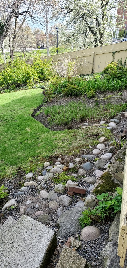
A sunny Memorial Day in the Greater Endicott Street Neighborhood.


Public Works: Salem 1957-1958

“Cities have the capability of providing something for everybody, only because, and only when, they are created by everybody.” Jane Jacobs, The Death and Life of Great American Cities 

Do cities ever stop building? Are they ever finished? I don’t think so, and for a relatively small city, Salem seems to me to have been especially busy building over these past few decades with more to come. Its 21st-century building boom began with courthouses: the Ruane Judicial Center which set the standard for the expanded scale of new construction and a gorgeous renovation and addition at the Probate Court next door, leading to a new parking garage across the way and ultimately to an adjacent residential building which will block the view of the Probate Court as one drives into town but also provide the funding for the restoration and redevelopment of the obsolete and proximate Victorian and Greek Revival courthouses. The Ruane courthouse also rendered the 1970s District Court across Washington Street obsolete and so it was demolished and replaced by a large residential builing called the Brix, and at the southern end of this same street an even larger Lego-like Hampton Inn now rises above the fray. This has all been a bit overwhelming, and more big projects are on the way! When I feel pressed by the present I always escape to the past for some perspective and a newly-digitized collection from the PEM’s Phillips Library gave me just that: photographs taken by Salem contractor William Franklin Abbott, chiefly of Salem’s big tunnel project of the 1950s as well as the construction of Lee Fort Terrace, a public housing community for the elderly of which he was Clerk of the Works. There are other collections of photographs of the the tunnel construction (I’ll put some links at the end) but I find Abbot’s color images especially captivating: how did the residents of Salem live through this all-consuming Big Dig???

October 1957

Well, they persevered, I guess, as Salem residents always do. The newspapers report that between 25 and 40 downtown merchants shut their doors during the delayed construction, some for good, apparently. The timing of the project was not good: construction of the Northshore Shopping Center, just a few miles away in Peabody, was concurrent, and as been noted millions of times, the latter had a great deal to do with the end of Salem’s reign as shopping center of Essex County. There were rats, there was noise, there was a rank odor present downtown due to the diversion of sewage pipes into the North River. Yet the City had been gearing up for this project since the beginning of the twentieth century, particularly as the grade crossings at Bridge and Norman/Mill Streets were seen as a “constant menace” and the source of increasing congestion. WPA funds were designated for a comprehensive plan including the construction of a new tunnel and station to replace the pioneering 1839 tunnel and 1847 Gothic Revival depot, fondly referred to as the “Old Castle”  but not as beloved in its declining years as it became after it was gone. Nevertheless, work did not begin for a decade later, with the commencement of construction on the Bridge Street overpass. After its completion in 1952, there seems to have been a pause until 1954, when the Depot was demolished and work commenced on the southward extension of the tunnel. The target completion date was 1956, but its completion was delayed until 1959 due to (take your pick): 1) the over-his-head contractor; 2) poor management at the state level; 3) a national cement drivers’ strike; 4) change orders—especially a switch to steel pilings. The summer of 1957 was hot with hearings! Abbott’s photographs illustrate the most intense phase of construction, from a professional perspective.

Above: Boston Globe: Salem’s “ancient” station featured in a December 1938 article; headlines from the summer of 1957; Below, Abbott’s photographs of the construction, 1957-58, first looking south, then north.

November 1957-February 1958, looking southward.

April 1957-January 1958, looking north.

There are more photos, especially of the southern extension of the tunnel, but I was focused on downtown: I can’t even begin to imagine the daily disruption! We hear about the suffering merchants, but I can’t find a source that testifies to the experience of mere Salem residents, trying to go about the business of daily life. I can imagine Abbott walking over from his office on Norman Street during his lunch, observing and documenting the ongoing construction with great interest. You can discern a much more personal perspective in his photographs of the construction of Leefort Terrace as he is as focused on the workers as the work-in-progress. Pride comes through, and there are photographs of the dedication ceremony, including a nice shot of Governor Foster Furcolo and Mayor Francix X. Collins looking like the pols they were (actually I don’t know much about either of them, but those hats make them look like pols). These little brick buildings are not long for this world, as a the City has established a partnership with a Boston development firm, Beacon Communities, to replace them with a multi-story building. Public-private partnerships seem to be the trend going forward with Salem construction projects, including the Offshore Wind Terminal which will be built on that part of the site of our former coal plant which was previously designated for public use. While this project has the potential to reap huge benefits for the economy and the environment, its scale is huge, and its construction and operation will affect the residents of the greater Derby Street neighborhood in myriad ways. They will have to persevere, as will my neighbors in the greater Endicott Street neighborhood, who are faced with a dramatic expansion of the presence of a Marblehead-funded philanthropic organization in the form of three five-storey buildings which will cast their much-smaller dwellings into perpetual shade.

Building Leefort Terrace in 1957-1958; Governor Furcolo and Mayor Collins.

Appendix/ More Sources for Salem’s Tunnel project:

Salem’s “Big Dig” at SSU Archives & Special Collections.

Historic Beverly’s Walker Transportation Collection.

Baccari Collection of “New Salem Tunnel” project photographs at SPD.


When Salem had Castles

I’ve got castles on my mind: all my courses this semester have an architectural theme and I’m in the midst of long survey of encastellation in my medieval course, using castle-building to explain virtually everything and anything. I often strive to connect teaching and living, to look around my own environment for connections to the past. For my Americanist colleagues, Salem and its region can serve as a classroom, but I’ve got to be a bit more creative. Sometimes it is easy: just last week we were discussing the Roman Republic in my world history class and we arrived at the Cleopatra representation issue, and there was Salem sculptor William Wetmore Story’s very influential statue/case in point. When I’m teaching the Reformation and the early modern era, it’s easy to bring in Salem from time to time, but this semester I have only world and medieval/Renaissance courses so there are not many opportunities for place-based history. But castles can be American in their decorative reincarnations, and we have several examples in our own region: Hammond Castle in Gloucester, Herreshoff Castle in Marblehead, and Winnekenni Castle up in Haverhill. The busy city of Salem was never a summer residential destination for Gilded Age millionaires, so no large castle-esque “cottages” were ever built along its shores, but there was a strong Gothic Revival influence at work in the mid-nineteenth century, very evident primarily in civic and ecclesiastical architecture from that era. These buildings are as close as Salem gets to castles and while some survive, most do not. My list starts with the most castle-like structures, long gone, proceeds through the nearly Norman, and ends with the “castle” with the most potential.

The Salem Armory and the Eastern Railroad Depot WERE castles right in the midst of downtown Salem, and their loss is still being felt, I think: you can see how integral they were to Salem’s evolving streetscape in every photograph. The Armory was nearly restored by fire in 1982, its surviving drill shed was converted into the Salem Armory Visitor Center in1994, and its Head House facade demolished by the Peabody Essex Museum in 2000. The Depot was built in 1847 and demolished in 1954. Certain views of the pre-fire Naumkeag Steam Cotton Company mills, otherwise known as Pequot Mills, make the buildings look castle-eque, especially the view from Derby Wharf below, which shows the facility’s crenellated towers. No castle features were incorporated in the post-fire buildings.

Kernwood, the North Salem estate of Francis Peabody, was Salem’s only palatial summer residence and so I am including it here: it is less fortified Normanesque and more Gothic Revival confection, though it does have a stone “rustic arch” surviving as the entrance to Kernwood Country Club. Kernwood was built in 1840, after Peabody had advocated for a number of Gothic constructions throughout Salem, including the First Church on Essex Street and Harmony Grove Cemetery. The photos below are from a series of Essex County views published in 1884 and Frank Cousins in the 1890s: I’m not sure exactly when the mansion came down, but the Country Club was established in 1914 and Walker Evans captured the converted clubhouse still looking very Gothic in the early 1930s.

The other castle-esque constructions in Salem were churches, all of which survive: St. Peter’s Episcopal, the First Church on Essex, and the East Church on the Common. St. Peter’s was designed by Boston architect Isaiah Rogers and constructed in 1833; the First Church was built three years later with Francis Peabody overseeing the construction. I’m curious if Salem residents in that decade noted the similarity and wondered: wow, is our city going to be taken over with these medieval structures the same way we wonder about the plastic boxes which define our era? I want to believe that the integrity of craftsmanship and materials would have reassured them, but who knows? In the next decade, the most castle-like church was constructed: the East Church on Salem Common. Designed by New York City architect Minard Lefever, the East Church had soaring towers that were truncated later, just as its function was reduced to the present-day Witch “Museum”.

The First Church, St. Peter’s (2) and the First Church today; Frank Cousins photograph of the East Church, Phillips Library via Digital Commonwealth.

Last, but certainly not least, the “castle” with potential: the old superior court building on Federal Street. Behind it (to the north) will rise a dreadful new building shoe-horned into a sliver-shaped lot, but that will be the price we pay for restoration of this amazing courthouse. Its turret and tower (best viewed from the rear) are so soaring and its interiors so baronial: I’m really glad that this building (which has been empty for decades now) is going to be preserved with a new purpose. I have no idea what that purpose will be, but I vote for a new Salem museum/visitor center with authentic exhibits and professional interpretation of all of Salem’s history: an installation which will defend our city from encroaching tourist trapdom.

Front of the former Superior Court at Salem, 1954, Brearley Collection, Boston Public Library via Digital Commonwealth; back–a bit foggy view taken yesterday at twilight: it’s difficult to capture the entirety of this building!


After the Fire: a New Salem Saltbox

I like to recognize the anniversary of the Great Salem Fire (June 25, 1914) every year, or most years, as it was such a momentous event in so many ways, starting, of course, with sheer destruction and dislocation: 1376 buildings burned to the ground (out of around 5000 structures in Salem proper), 18,000 people lost their homes and 10,000 people lost their jobs. Only three people died, which seems incredible given the magnitude of this conflagration, but 60 people were injured. Like every disaster of this scale, there are so many topics to address about its aftermath: the immense shelter and aid effort, the rapid rebuilding program, the plans for a “new” Salem. New might not be the correct word, as the architects and planners and owners who sought to rebuild on the broad swath of fire-ravaged land along Lafayette streets and the harbor were very interested in fire-resistant building materials but their aesthetic preferences were more traditional. This is a moment when Colonial Revival Salem comes into full flower, after germinating for several decades. You could label the traditional brick, stucco, and wooden buildings which line lower Lafayette and its side streets “conservative” but I prefer the terms referential or contextual: I’m always impressed with the deep appreciation displayed by early twentieth-century architects for Salem’s colonial and federal architecture and their desire to study and emulate heritage buildings. Perhaps post-fire architects, builders and planners were a bit too deferential to the past (architectual author and photographer Frank Cousins seems to view the opportunity before Salem as one of colonial compensation after all those sub-par Greek Revivals and Victorians were swept away) but I’m alway happy to see the past privileged over the present. I thought I’d illustrate this Colonial Revival moment with just one “new” house: a saltbox built on Cedar Street for Mr. and Mrs. George A. Morrill as designed by architect A.G. Richardson.

Two Cedar Street, built 1815: today, in the 1980s, and as newly-built.

A.G. Richardson was a Boston architect who lived in Salem, and thus the recipient of quite a few post-fire commissions. His pre-fire work does not seem to be overwhelmingly reflective of colonial inspiration, but more like a mix of old and new. He did design a “new Colonial house” for a harborview lot on Lafayette which was featured in House and Garden magazine in June of 1907. But the Morrill house at 2 Cedar Street looks much more traditional, and Frank Cousins and his co-author Phil Riley even praised it as “practical” in their Colonial Architecture of Salem (1919): “the resulting house as it stands to-day represents virtually and exact copy of the Maria Goodhue house in Danvers, erected in 1690 and destroyed by fire in 1899. Its long roof-line, formed by the lean-to continuation of the same pitch, contributes a uniquely appropriate character to the modern architecture to the modern architecture of Salem and was found to provide a very practical way of bringing a piazza in the rear and all service appurtenances under one roof, thereby saving expense and avoiding all leadage complications common to roors considerably broken by gables or dormers.” Riley had praised the Morrill house earlier as “in the spirit of old Salem” in his 1916 article in The House Beautiful, but I think I should note that there were not many surviving saltboxes in early twentieth-century urban Salem, so Richardson had to look to nearby Danvers for inspiration! Fortunately Cousins had photographed the Maria Goodhue house (see below, from the Cousins Collection at the Phillips Library via Digital Commonwealth) before it was destroyed by fire. The new door of Two Cedar Street was definitely old Salem, however: Richardson copied the entrance of the Captain John Hodges House on Essex Street.

There was something about the Fire that fueled preservation in Salem and elsewhere, as story after story in national newspapers and periodicals emphasized the fact that the older sections of Salem escaped its path: an early report indicated that the House of the Seven Gables had been swept away, and it seems like there was a collective sigh of relief when it was revealed to be false. Wallace Nutting, that exemplar of the Colonial Revival, featured ethereal ladies draped in timeless white dresses on the steps of Chestnut Street houses spared from the fire in his 1915 “expansable” catalog, and the equally timeless saltbox merged colonial charm, clean lines, and (space for) modern conveniences.


Skirting Witches and Pirates in Salem

Walking is my preferred form of transportation in Salem, but I tread carefully: I want my path to be lined with beautiful old houses, colorful shops and lovely green (or white) spaces. Attractions exploiting the terrible tragedy of 1692 and out-of-town-yet-territorial pirates cloud my view and dampen my day. I’m happy to meet real witches and pirates on my walkabouts, but kitschy parodies annoy me. If you are of like mind, there are many routes you can take in Salem on which you will not cross paths with anything remotely touristy, but if you are venturing downtown you must tread carefully too. Avoid the red line at all costs and follow my route below, which I have superimposed on an old map of the so-called “Heritage Trail”: I’m starting at my house on lower Chestnut Street and making a witch-less circle.

Across from my house is Chestnut Street Park: this is not a public park but a private space, owned by all the homeowners of Chestnut Street. It was once the site of two churches in succession: a majestic Samuel McIntire creation which lasted for almost exactly a century and was destroyed by fire in 1903 and a stone replacement which was rather less majestic and lasted about half as long. The gate is usually open to everyone, but not for reseeding time as you can see by the sign. I walk down Cambridge Street by the park and across Essex into the Ropes Mansion Garden, not looking great now but an amazing high summer garden. Then I walk down Federal Court and across Federal Street to the Peirce-Nichols House which is owned, like the Ropes Mansion, by the Peabody Essex Museum. Unlike the Ropes, I can’t remember when the Peirce-Nichols was last opened to the public: it’s been decades. It has a lovely garden in back which was always open, and my favorite place to go at this time of year because of its preponderance of Bleeding Hearts. The gate to the back of the house has been closed for a couple of years now, but it is latched and not locked, so I entered and went into the rear courtyard, passing the memorial stone dedicated to the memory of Anne Farnam, the last director of the Essex Institute before it was absorbed into the Peabody Essex Museum on my right. I never knew Anne but I’ve learned a lot from her articles in the Essex Institute Historical Collections so I always pay tribute. The gate to the garden in back was latched and locked, so I presume the museum does not want us to venture in there. I hope it was ok to go that far! While I am grateful for these pem.org/walks recordings I’m always wondering why these houses are never open.

Continue down Federal Street past the courthouses: you must avoid Lynde Street and Essex Street where witch “attractions” abound. I take a left after Washington street onto a street that no longer exists: Rust Street. I like the juxtaposition of the newish condominiums and the old Church and Bessie Monroe’s brick house on Ash Street on the right: a symbol of the opposition to urban renewal in Salem. Then it’s on to St. Peter Street, past the Old Jail and the Jailkeepers’s House (below), right on Bridge, and then right again, onto Winter Street.

Winter Street

As you approach Salem Common, you must bear left and head for the east side, as the west side is the territory of the Salem Witch “Museum.” There are some side streets with wonderful houses between the Common and Bridge Street which might be a bit more pleasant to traverse than the latter but you will be cutting close to the “Museum”: that’s why I always go with Winter. Once there, go straight by the Common on Washington Square East : you will pass the newly-renovated Silsbee Mansion, which long served as the party palace Knights of Columbus and has been converted into residential units with a substantive addtion and exterior restoration, and one of my favorite houses on the Common, the Baldwin Lyman House.

On Washington Square East.

Washington Square East will take you right to Essex Street: cross and go down the walkway adjacent to the first-period Narbonne House into the Salem Maritime National Historic Site. No witches or pirates here: you’re safe! I love the garden behind the Derby House: I think it is probably at its best in June when the peonies are popping but it’s a great place to go all spring and summer and even in the fall. On Derby Street, you can turn left and go down to the House of the Seven Gables or go straight down Derby Wharf: I went to the end of the wharf on this particular walk. The Salem Arts Association is right here too, but beware: there is a particularly ugly witch on its right so shade your view lest your zen walk be disturbed.

Salem Maritime National Historic Site and the Salem Arts Association.

Back on Derby. Adjacent to the Custom House is a wonderful institution: the Brookhouse Home for Women, established in 1861! The Home is located in the former Benjamin Crowninshield Mansion, and it is very generous with its lovely grounds, which provide my favorite view of Derby Wharf. I always stop in here, and then I work my way back up to Essex Street on one side street or another. Essex Street east and west are wonderful places to walk, but the pedestrian-mall center is witch-central: a particularly dangerous corner is Essex and Hawthorne Boulevard, where the Peabody Essex’s historic houses face some of the ugliest signs in town. It’s a real aesthetic clash: gaze at the beautiful Gardner-Pingree House, but don’t turn around! If you want to go to the main PEM buildings or the Visitors’ Center further down Essex, approach from Charter Street north on another “street” that no longer exists: Liberty Street.

From the Brookhouse Home to the PEM’s row of historic houses on Essex Street. Memorial stone in the Brookwood garden: Miss Amy Nurse, RN, an Army Nurse (1916-2013).

Charter Street is the location of Salem’s oldest cemetery, the Old Burying Point, recently restored and equipped with an orientation center located in the first-period Pickman House, which overlooks the Witch Trials Memorial. So this is a wonderful, meaningful place to visit, but beware: just beyond is the “Haunted Neighborhood” or “Haunted Witch Village” (whatever it is called)  situated on the southern end of the former Liberty Street, abutting the cemetery. This is a cruel juxtaposition during Haunted Happenings, when you literally have a party right next to sacred places, but not too noticeable during the rest of the year, because for the most part witchcraft “attractions” create dead zones. But the tacky signage can still spoil your walk so avert your gaze as much as possible. Charter Street feeds into Front Street, Salem’s main shopping street, and from there you can find the path of least (traffic) resistance back to the McIntire Historic District, which is very safe territory. Broad, Chestnut, upper Essex and Federal Streets are lined with beautiful buildings, as are their connecting side streets, so take your pick. I usually just walk around until I get in my 10,000 steps: on this particular walk I ended up on Essex.

Charter, Front & upper Essex Streets.