Monthly Archives: May 2011

Civil War Remembrance

Collective memory and expressions of remembrance have been fashionable topics among historians of the last generation or so; it seems like European historians prefer to focus on the culture of remembrance that developed after World War I while American historians dwell on that of the  Civil War.  These were devastating conflicts in so many ways.  And of course World War II has its own unique commemorative culture.  I find that holidays in general, and summer holidays in particular, are a great time to develop, or solidify, a sense of place, an increasingly elusive feeling in this generic world.

Given the fact that we’re in an anniversary year–the 15oth anniversary of the beginning of the Civil War–I decided to follow the path laid out by the Grand Army of the Republic (G.A.R.), America’s first veteran’s organization and the inspirational force behind Memorial Day ( which was first known as “Decoration Day” and exclusively devoted to Civil War veterans) and examine Civil War remembrance here in Salem.

Before I get to Salem, a brief detour back to my hometown of York, Maine, where the Civil War statue resembles a CONFEDERATE officer, or at least what we have come to perceive as a Confederate officer.  He looks odd not because he is incorrectly garbed but because he is anachronistically garbed, in the Spanish-American War uniform that was contemporary to the time of his creation in 1906.  This statue, like all historical monuments, is reflective of both the time of its installation and the time it commemorates, perhaps more so the former than the latter.

Back to Salem.  There is a Civil War plaque adjacent to the Common but the cemeteries provide a less perfunctory form of commemoration, I think.  Salem has many old cemeteries, but the two newest and largest ones, Greenlawn and Harmony Grove, have the most Civil War grave sites as well as designated shrines.  Both are nineteenth-century “garden” cemeteries;  Greenlawn is public and thus a little worse for wear while Harmony Grove is private though still very accessible.  Actually, Greenlawn’s slight shabbiness adds to its poignancy, represented so well by the Gothic Dickson Chapel in its midst.

Down the path to the monumental Civil War statue, dedicated in the 1880s, surrounded by the graves of Salem men who lost their lives during the War between the States.  Their markers are very subtle, so obscured by grass you don’t realize what they are until you’re right on top of them.  All the attention is focused on the large monumental anonymous (but recognizable) Union soldier in the center of the mound, who represents all of them.  This statue bears all the marks of the official Civil War commemorative organizations, both the G.A.R and the Sons of Union Veterans of the Civil War.  Lieutenant Colonel Henry Merritt, the namesake of the SUVCW Camp, was killed at the battle of New Bern in April of 1862.

The Battle of New Bern, Harper's Weekly, April 1862

Over to Harmony Grove, a beautiful, terraced cemetery laid out in a series of winding paths lined by the crypts and semi-enclosed plots of some of Salem’s most prominent families.  Despite a circle of decommissioned cannons,  Harmony Grove’s Civil War installation is not as impressive as Greenlawn’s, and many of the individual soldier’s graves are in a deteriorating condition.  A bit further down the path, however, is the impressive grave of one of Salem’s most eminent Civil War heroes, Luis Fenollosa Emilio (1844-1918).

Emilio was part of the amazing Fenollosa-Emilio family of Salem, Spanish immigrants and ardent abolitionists.  He was a cousin to Ernest Fenollosa, the future Japanese cultural minister who I wrote about in an earlier post.  Even though he was only 16, Emilio had enlisted in the army at the beginning of the Civil War, and when Massachusetts Governor John Andrew created the first Northern black regiment in 1863, the 54th Massachusetts Volunteer Infantry Regiment (memorialized in Glory), he sought and received an officer’s commission.  In fact, Captain Emilio was the only officer of the 54th who survived the disastrous assault on Fort Wagner and successive conflicts to tell the tale of the Regiment, which he did in A Brave Black Regiment.  The History of the Fifty-Fourth Regiment, or Massachusetts Voluntary Infantry, 1863-65 (1891).


Wrapping up my cemetery tour, I took a walk through the much older and smaller graveyard near my home.  There were no flags here; these veterans lie unacknowledged.  Two particularly poignant markers caught my eye, one of a seldom-heralded Revolutionary War soldier named Joshua Cross, and the other of Samuel Cook Oliver, a Civil War veteran who was severely wounded at the Battle of Antietam [and] died after many years of suffering cheerfully and bravely borne.


Rozanne Hawksley’s Wreaths

In advance of Memorial Day, I thought I would showcase several works of the great British textile artist Rozanne Hawksley (b. 1931).  As a World War II evacuee, many of her textile collages and installations feature the general themes of war, loss and remembrance; I find her funeral wreaths particularly poignant and also beautiful.  But you have to look closely.  Her most famous, or at least photographed, work is Pale Armistice (1991), which is in the permanent collection of the Imperial War Museum in Britain.

Pale Armistice is a textile sculpture collage made of overlapping vintage white men’s and women’s gloves.  It looks bridal rather than funereal, but tucked in amongst the flowers and gloves are bleached bones.  The gloves signify marriage but also loss; the piece was made in memory of Hawksley’s grandmother who lost her husband in World War One, one of many war widows of her generation.

Two more Hawksley wreaths employing found objects and evoking loss are Caiphus (2007) and Memorial Wreath.  The latter, from the Imperial War Museum’s current exhibition Women War Artists, is more obviously a funeral/memorial wreath, made of a seagull’s skull, around which is draped  the traditional black silk square that forms part of a British sailor’s uniform when rolled into a neck tie.

See also: rozannehawksley.com; Rozanne Hawksley by Mary Schoeser.


Very Odd Apples

My title actually refers to tomatoes rather than apples, a great example of a New World crop that was introduced into Europe though the “Columbian Exchange” and then brought back to America in the eighteenth century. Like another consequential import from the western hemisphere,  the potato, the tomato was slow to find acceptance among Europeans, primarily due to its first introduction in print by the Italian physician and botanist Pietro Andrea Mattioli (Matthiolus) in his 1544 Commentaries (the tomato page from a 1590 edition is below).  Matthiolus refers to the tomato as a “poma aurea” or golden apple, which is generally taken as evidence that yellow tomatoes preceded their red counterparts across the Atlantic.


Matthiolus tells his readers how to eat the tomato (fried in oil with salt and pepper) but he also classifies and compares the new vegetable (fruit?  He is confused as well) to the mysterious magical mandrake, which gives it a rather malevolent reputation in the early modern era.  Northern naturalists included the tomato in their “new” herbals in the sixteenth century, with name variations but the same magical associations. Conrad Gesner stressed the aphrodisiac qualities of mandrake but maintained its connection to the new plant in his Historia Plantarum (1553),  and thus “golden apples” became “love apples” (and sometimes “wolf’s peaches”) in northern Europe while in Spain the term “Moor’s apples” prevailed.  The most beautiful herbal of the sixteenth century, Leonart Fuchs’ De historia stirpium, included an illustration of the tomato in its later editions, as did Rembert Dodoens’ Cruydeboeck:

The most comprehensive herbal issued in sixteenth-century England, John Gerard’s Herball, was primarily plagiarized from Dodoens’ earlier work (there was a lot of “sharing” in the early modern publishing industry), but Gerard was a gardener who experimented with tomato cultivation (and consumption) himself.  He found the plant to be “of rank and stinking savour” and added this commentary:  In Spain and those hot regions they use to eat the Apples [of love]  prepared and boiled with pepper, salt, and oil:  but they yield very little nourishment to the body, and the same naught and corrupt.  Likewise they do eat the Apples with oil, vinegar, and pepper mixed together for sauce to their meat, even as we in these cold countries do mustard.”  An early reference to tomato sauce, this observation also tells us a lot about the difference between Mediterranean and northern European cuisines, then and now!

Taking their cue from Gerard, the tomato was scorned in Anglo-American cuisines until the modern era, despite efforts by such varied advocates as Thomas Jefferson, who cultivated tomatoes at Monticello, and the Neapolitan artist Michel Felice Corne, who escaped the Napoleonic Wars by departing Naples in 1800 on one of Elias Hasket Derby’s Salem-bound ships, the Mount Vernon.  Corne lived and worked in Salem for the next six years, ostensibly introducing both Italian painting techniques and Italian tomato sauce to the town, but Salemites would have none of the latter.  It would take another half-century or so, and a huge wave of Italian immigration, for “love apples” to become American (again).

Michel Felice Corne, The Ship Mount Vernon of Salem Outrunning a French Fleet

An 1869 Advertisement, Library of Congress


Maps Come Alive

In the course of putting together my summer graduate seminar on the expansion of Europe this past weekend  I reacquainted myself with some digital map collections on the web.  Maps provide an accessible entryway into this topic, in every era of European expansion.  The shift from conceptual to more realistic cartography in the early modern era is a very evident and important trend, but early modern mapmakers retained a bit of whimsy when they produced maps in the form of plants, animals and humans in the sixteenth and seventeenth centuries.

The maps contained in German theology professor Heinrich Bunting’s Travels according to the Scriptures (1581) are very popular with my students and with the blogosphere:  the known world as a clover leaf, part of Asia as the flying horse Pegasus, Europe as the classical virgin Europa.  This is still very conceptual geography; the clover leaf map is merely a new version of the medieval T-O map, in which the world is inhabited by the descendants of Noah dwelling in Asia, Africa and Europe.  Jerusalem is at the center of the world as it has always been.   Even though it is almost a century after Columbus, Heinrich’s “world” map only references the eastern hemisphere.  His Europa map was stolen from one of the most popular books of the sixteenth century:  Sebastian Munster’s Cosmographia, first published in 1544 and issued in many editions by the end of the century.  This is what these new, colorful, fantastical maps are all about:  competition in the new age of print.

Another Europa:  Sebastian Munster’s version from a 1570 edition of Cosmographia:

Another lively early modern map is the “Dutch Lion” map (Leo Belgicus, Leo Hollandicus ) issued in a succession of variations from the late sixteenth century, contemporaneously with the Dutch Revolt against Spain.  The rebellious Dutch provinces are shown in the form of a lion, roaring in the face of the powerful Spanish Empire.

"Leo Hollandicus", JC Visscher, 1648

Anthropomorphic and zoomorphic maps continue on into the modern era; they seem to be quite popular in the nineteenth century as a forms of political commentary and expressions of public opinion.  These satirical maps are especially prevalent after 1870 and the unification of Germany:  French and English versions definitely contain an alarmed awareness of the potential of the new empire to dominate the Continent, as these examples( L’Europe Animale, 1882 and Angling in Dangerous Waters, 1889) from the huge collection of such maps at the University of Amsterdam illustrate:

In L’Europe Animale, Germany is a sly wolf waiting to pounce, while the Angling map personifies the nation with its militaristic ruler, Kaiser Wilhelm II, who is looking over the horizon.  The great big Russian bear and Tsar Nicholas are pretty intimidating as well.  The end result of all this animosity was of course World War I, and BibliOdyssey has a great post on the jingoistic satirical maps of the Great War here, including the English map “Kill that (German) Eagle” from 1914.

On the lighter side:  plates from William Harvey’s Geographical Fun.  Being Humourous Outlines of Various Countries, an atlas (presumably for children but quite sophisticated in its humor) first published in 1869.  The entire text can be found at the Library of Congress, and it has also been republished.  Here, from a very British perspective, are France and Prussia (it’s just before the unification of Germany):

Finally, I can’t resist adding an elephant to this group even though he’s not quite a map:  a World Wildlife Fund advertisement by Ogilby and Mather from our own time:


Houses on the Move

There are countless ways that our ancestors were more environmental than us, though of course they didn’t see it that way:  they just didn’t like to waste.  Anything.  The whole idea of  “tear downs” would have been repellent to most people (maybe not nouveau riche millionaires) a century and more ago; if they wanted a bigger house or a house in another location, they just added on or moved the entire structure:  with horses, with oxen, by rail.  This still happens; the huge new courthouse project that is now coming to a close in Salem involved the moving of a huge brick Baptist Church and the preservationist practice of selling endangered houses for a dollar with the stipulation that they be moved is pretty standard.  But it is far less common than it was in the nineteenth century, when one gets the impression that there were many houses on the move.

The First Baptist Church on the move, January 2009 and the moving of the Peter Green house in Providence last year.

This post is one of several that I could do on houses that have been moved in Salem.  Like many older cities in the east, both public and private motivations have resulted in lots of building relocations. I have excluded the houses that have been moved by the House of the Seven Gables and the Peabody Essex Museum, both of which created “museum neighborhoods” by moving historic structures.  The latter wins the award for the house that has moved the farthest distance:  its eighteenth-century Chinese house, Yin Yu Tang, came from halfway around the world!  But even excluding these institutions, there are lots of Salem houses that have been moved, in their entirety, or in pieces.

I’m starting out with one of my very favorite houses, the Robert Manning cottage on Dearborn Street in North Salem.  This adorable  Dutch Colonial cottage was built by Nathaniel Hawthorne’s maternal uncle Robert Manning for his widowed sister, and Nathaniel lived there with his mother after his graduation from Bowdoin College.  The cottage was then across and down the street from its present location, adjacent to Manning’s own house and famous nursery, orchard and garden.  After the house passed out of the Manning family in the 1850s  it was relocated, though its original ell remained behind.

Frank Cousins Photograph, 1901

A more challenging move, both in terms of bulk and distance,  involved the Mason-Roberts-Colby-Nichols House, which was transferred from the Common to Federal Street by 60 oxen in 1818.  The relocated house then underwent a Federal makeover and acquired several additions, including the “Beverly jog” seen below.

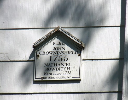
Relocation following redevelopment: many houses in Salem were moved because of street widening and other infrastructural modifications and larger institutional building projects.  The two Georgian colonial houses below were removed from St. Peter Street to nearby Kimball Court to make way for the St. John the Baptist Church complex at the turn of the last century.  The white house on Kimball Court (which acquired some interesting pillars after its move) is one of  several houses in Salem associated with the famed navigator Nathaniel Bowditch; the other Bowditch house (the present-day headquarters of Historic Salem, Inc.), where he lived for over a decade was moved (along with the Jonathan Corwin house) to make way for street-widening in 1944.

The Bowditch (Curwen) House in its original Essex Street location: a Frank Cousins photograph circa 1900

Bowdith house corrected

And here in its proper (past) situation–thanks to Mark Coughlin!

The Bowditch House today: around the corner on North Street

The sum of all their parts:  often houses were not moved in their entirety, but in pieces, and either reconfigured in a new enlarged house or attached to a pre-existing house in another location.  It is a quite a feat to figure out when and where and how precisely all this disassembling and reassembling happened in Salem, or any other similar town, but here are a few examples of  it:  another house with Bowditch connections, a portion of which was the Samuel Curwen house and store, an interesting house moved to a side street off Derby Street in 1856 which seems to consist of at least three, if not more, earlier houses, and the amazing Benjamin Punchard house on Federal Street, whose origins are somewhat shrouded in mystery but is believed to be a product of a colonial building moved to the site a decade before the American Revolution and later Federal-era additions.

The most interesting example of a partially relocated and reconstituted house is the Phillips House on Chestnut Street, now one of Historic New England‘s properties.  The house was erected (or assembled) in 1821 by Captain Nathaniel West, who moved part of  Oak Hill, the magnificent country estate of his deceased ex-wife (Elizabeth Derby West, daughter of Elias Hasket Derby, Salem’s wealthiest merchant and perhaps America’s first millionaire) in nearby South Danvers (now Peabody) to Chestnut Street and added additional rooms to create a new (late) Federal mansion.  Mrs. West had wanted the Captain to have nothing to do with Oak Hill, but after both her death and that of one of their daughters, he inherited a third of the estate and promptly removed his inheritance to Salem, creating a “spite house” of sorts just down the road!  A century later, the Phillips family commissioned architect William Rantoul to remodel the Chestnut Street house in the Colonial Revival style, and later still, sadly, Oak Hill was demolished to make way for the Northshore Mall.

The Phillips House in 1940, HABS, Library of Congress.  Frank O. Branzetti, Photographer.


The Pedrick Store House

At this week’s annual meeting of Historic Salem, Inc. the Salem Maritime National Historic Site was given a Preservation Award for the relocated and reconstructed Pedrick Store House, a circa 1770 building that was situated on nearby Marblehead’s harbor until 2003, when it was acquired by the National Park Service and moved to Salem.

A postcard of Tucker’s Wharf in Marblehead, with the store house in its original location (the larger structure on the left) is below.  When the town’s efforts to restore the building were unsuccessful and its razing imminent, the Park Service stepped in and moved it to Salem in pieces, commencing a six-year period of storage and reconstruction (using traditional techniques) on Derby Wharf.

For as long as I’ve lived in Salem, and certainly since the arrival of the replica Friendship in 1998, there has been discussion of the necessity of having more structures on Derby Wharf, in an ongoing effort to recapture at least some semblance of the frenzied commercial activity on the wharf in Salem’s golden age.  All the literary and visual evidence indicates that Derby Wharf, along with Salem’s other wharves (now mostly gone) were lined with multi-story store houses and outbuildings to service all aspects of the port’s business in the early nineteenth century.

Even a century ago, there were both more wharves and more buildings on the wharves.  The Salem artist Philip Little (1857-1942), Chestnut Street resident, civic leader, brother of architect William Little (who I wrote about here) and good friend and neighbor of fellow Salem artist Frank Benson (who I wrote about here) maintained a small studio overlooking Salem Harbor and was particularly inspired by the old wharves and wharf buildings which were still extant, but obviously in decline, during his lifetime.  He produced variations on the old Salem wharves image in many different mediums, including the etching, photograph, and oil painting below (Salem’s Old Wharves, 1915, Smithsonian American Art Museum; Derby Wharf, 1910 and A Relic of History, Old Derby Wharf, 1915, both Peabody Essex Museum and Salem State University website Salem in History). 

Little’s use of the word “relic” in the title of this last painting is interesting; it is an acknowledgement that the Wharf as he was capturing it was a remnant of the past, on its way out.  And soon the buildings of the wharf were gone, though the wharf itself survived because of its acquisition by the federal government and assimilation into the Salem Maritime park.  And as is often the case when things disappear, you notice their absence and want them back.


Painting Abigail and Apple Blossoms

Two lesser-known (at least to me!) Salem artists were born this week:  Benjamin Blyth (or Blythe, 1746-1811) and Fidelia Bridges (1835-1923).  Blyth was a colonial portrait pastellist, whose subjects included Abigail and John Adams in the early years of their marriage,while Bridges was a watercolorist and illustrator whose late nineteenth-century nature scenes expressed both the realism and the romanticism of her era. 

Even before Blyth placed an advertisement in The Essex Gazette begging “leave to inform the Public, that he has opened a Room for the Performance of Limning in Crayons at the House occupied by his Father in the great Street leading towards Marblehead, where specimens of his Performance may be seen” in October of 1769, he had received commissions from notable persons in the Salem and Boston areas, including the Adamses.  Apparently Abigail Adams’ sister lived in Salem, and the young married couple sat for Blyth during a visit with her in 1766. 

Abigail Adams and John Adams, Collection of the Massachusetts Historical Society.

The very first portrait of a future president (and present historical rock star) painted right here in Salem!  According to Neil Jeffares’ Dictionary of Pastellists before 1800, Blyth produced over two dozen pastel portraits during his career, but attribution is difficult because he seldom signed his work.  Two other prominent people who were painted by Blyth (perhaps not as prominent as the Adamses but certainly very important Salem people) were Dr. Edward Augustus Holyoke (1728-1829), physician, scientist, and early adopter of the controversial smallpox vaccination method (he inoculated himself during the epidemic of 1777) and architect-woodcarver Samuel McIntire.  Holyoke’s image was captured by several artists more famous than Blyth, including John Singleton Copley, but the image below remained in the family until its sale at auction in 2007 for $35,960.

 Dr. Edward Augustus Holyoke by Benjamin Blyth, circa 1777 (with a black and gilt frame by Samuel Blyth), Northeast Auctions image, 2007.

The sole image we have of Samuel McIntire is Blyth’s, painted at some point in the 1780s and in the collection of the Peabody Essex Museum.

While the date most commonly given for McIntire’s portrait is 1786, that would have been four years after Blyth left Salem for Richmond, Virgina, where he married a rich widow and continued his pastel portraiture. The last years of his non-Salem life seem somewhat shrouded in mystery.

And now for something (someone) completely different.  Fidelia Bridges was born in a very different Salem more than a generation after Blyth left, and she lived well into the twentieth century. Bridges was also a far better-trained artist than Blyth, despite her gender and the difficult circumstances of her early life. Her parents died in quick succession (her ship captain father in China, her mother at home in Salem three months later) leaving her orphaned by the age of 15. After a brief bout on their own, she and her siblings were taken in by the wealthy Browne family of Brooklyn,(not sure what the connection between the Bridges and the Brownes is:  cousins, friends of friends?) where Fidelia seems to have functioned as an unpaid combination mother’s helper/governess but was also exposed to the artistic environment of  New York.  By 1860 she was in Philadelphia, studying at the Pennsylvania Academy of Fine Arts with the pre-Raphaelite artist William Trost Richards.  The wealthy and well-connected Richards, though only a year older than Fidelia, became her lifelong mentor. 

Fidelia Bridges in 1864, Lay Collection, Smithsonian Archives of American Art

Fidelia Bridges’ works reveal small sections of nature, very closely-focused, detailed, and finely-drawn:  the essence of birds and/or plants, with nothing added.  She first worked in several mediums but became increasingly focused on watercolors, which apparently had increased in artistic stature at this time, and she was the first (and only, for a long while) female member of the American Watercolor Society.  Below are two watercolors from the 1870s: Bird’s Next in Cattails (Metropolitan Museum of Art) and Apple Blossoms (Babcock Galleries).

Though Bridges was well-connected and well-exhibited, she never married and had to support herself, which she could not do solely with the proceeds from the sale of her individual paintings.  Consequently she became an illustrator, an increasingly respectable (and remunerative) profession for artistic ladies in the later nineteenth century.  From the 1870s on, Bridges worked continuously for the printer-publisher Louis Prang & Company of Boston, providing illustrations for chromolithographic books, calendars, and greeting cards.  One of Prang’s most artistic (and expensive) offerings was a series of twelve color prints illustrated by Bridges in 1876:  Twelve Months.  Below is the month of May, from the collection of the Boston Public Library.

Though born in Salem, Fidelia Bridges is more associated with the western Connecticut town of Canaan, where her Prang earnings enabled her to purchase a small rural estate with a rather wild old-fashioned garden, providing her with subject material for the rest of her life.


The Willows in the Aughts

Inspired by my student’s paper and Maurice Prendergast’s painting below, and hoping for a bit warmer weather, here are some views of Salem’s seaside amusement park, the Willows, during its golden heyday at the turn of the last century. Formerly Salem Neck, the site of a smallpox hospital (for which its namesake white willow trees were planted around 1801, with hopes of creating a tranquil convalescent setting) and adjacent farmland, the Willows became a municipal park in 1858 and was further developed and expanded with arcades, “Restaurant Row”, and adjacent vacation cottages from the 1870s.  Two maps below, from the early and late nineteenth century, show its early development and connection to the main part of Salem.  The first map, from the Norman B. Levanthal Map Center at the Boston Public Library, shows an almost completely rural Salem Neck in the upper right hand corner while the second, from the Phillips Library of the Peabody Essex Museum via Salem State’s grant website Salem in History, illustrates a much more connected Willows.

 
The Salem Willows Amusement Park never rivalled the larger Coney Island-esque parks like Revere Beach to the south and Old Orchard Beach to the north, but it was an extremely popular local recreation destination for factory workers from nearby Lynn and the Merrimack Valley, who would take the train to Salem Station and then hop on one of the horse-drawn trolleys which travelled to the Willows every 15 minutes or so in the summer.  Once there, they found restaurants and picnic grounds, beaches for sunbathing, arcades, a casino, and the Pavilion, “flying horses” (a carousel) and an open-air theater, outgoing steamships, and lots and lots of people:  by several estimates as many as 10,000 a day on a summer weekend.  Much of the recreation that occurred at the Willows seems to have taken the form of promenading, a nice old-fashioned word (and activity) that is very well captured by Maurice Prendergast’s 1904 painting Salem Willows, the alternative title of which is Promenade, Salem Harbor.
 
 
Like Prendergast’s painting, postcards from the era (which must have been issued in the thousands, so many survive) convey the spirit of lazy, breezy promenading (by well-dressed people!) under the Willows.  Here is a sampling, all from just the 1906-1910 period. 


This last picture, from 1910, is prescient of things to come:  the automobile will certainly change the Willows in a myriad of ways over the coming century: bringing about the end of its strictly summer identity and the creation of year-round neighborhood of Salem.  While few of its turn-of-the-century structures still stand today, the Willows Park maintains a seasonal and somewhat timeless air about it, but adjacent Juniper Point has changed quite a bit, evolving from “tent city” to cottage colony to year-round residential community.


Student Work

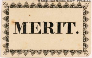
It is the end of the semester and this week was all about grading–always a humbling process which exposes the strengths and weaknesses of both instructor and students.  Sometimes I wish I could just whip out a stack of Reward of Merit cards and fill in my students’ names!  These little ephemeral scraps illustrate the evolution of assessment in American classrooms:  from handwritten Sunday School tokens of moral behavior in the eighteenth century to nineteenth-century printed cards issued to encourage more secular standards of diligence, punctuality and “comportment” and ultimately to twentieth-century report cards.  Here is a sampling of reward of merit cards from the collections of the Library of Congress, the American Antiquarian Society in Worcester, Massachusetts, and the New York Public Library Digital Gallery, dating from about 1830 through the 1880s.

A strikingly simple reward of merit card from the Rhode Island Historical Society via its delightful blog, A Lively Experiment:

This looks like a John Derian decoupage tray in the making! (Actually he’s already produced a reward of merit tray, available here).  While looking for some more examples in the online catalogue of the Winterthur Library’s Joseph Downs Collection of Manuscripts and Printed Ephemera, I came across the work of the New York Printer-Publisher Charles Magnus (1829-1900) and got quite distracted. Magnus came over from Germany around 1848 and soon flourished in New York City; his output included all forms of stationary and really beautiful birds’ eye views of North America’s major cities.  During the Civil War,  Magnus expressed his passionate pro-Union sentiments by issuing envelopes emblazoned with the seals of all the confederate states encircled by the Devil!  Well, as you can read, I’m going off on a tangent….here are two of Magnus’s rewards of merit:

While digitally digging around in the online archives of the Winterthur Library, I also found the image below, from a scrapbook of drawings, clippings, wallpaper scraps, and fabric swatches assembled by an anonymous young design student or interior decorator in the 1880s, maybe in Salem or the Salem area according to the stationers’ label:

I find this unbelievably charming–so much so that I’m gently forcing it into this post with only the Winterthur catalogue description that it is the work of a “young” decorator!  There’s something about (good) student work that is captivating; I think it is the recognition of potential combined with the lack of established, learned constraints.  Here we have the (giant!) bellows over the fireplace, a crazy-colorful rug, and somewhat strange scale and placement, all combined to create a really unique image.  The last stack of papers I have to correct are those from my research and writing seminar, our Department’s capstone course in which the students complete a serious research paper on whatever topic they choose.  You don’t have to imagine the diversity of topics; I’ve got papers here on Marblehead fishermen, New Bedford whalers, a mythical witch in central Massachusetts, the great Boston Molasses Flood of 1919, the Viking occupation of England, the building of the US Capitol, advertising images of 1950s housewives, and several on the development of New England amusement parks (for some reason!) including Salem’s own Willows, all of which deserve much more substantive assessment than a cursory reward of merit.


Spring around Salem

Just a few photographs of Salem sites with no particular connection other than the season.  It’s been a cold spring so far, and I think blooming is a little delayed—always the case with my own garden, which doesn’t look like much until a little later in the year.  I’m kind of a quirky gardener as I’m more interested in individual plants rather than the garden as a whole, and I tend to like plants with interesting historical connections, which generally means later-blooming herbs.  But I did inherit a nicely laid out garden from the previous owners of our house, bordered by boxwoods which thankfully survived the harsh winter.

The central perennial bed is above, and off to left is a little “woodland garden” with a pond and this amazing plant, which is in bloom right now.

Jack-in-the-pulpit (Arisaema triphyllum)!  Aren’t they amazing?  They always surprise me this time of year, along with my yellow lady slippers which are not quite ready for exposure.  Across the street from our house, is “McIntire Park”, the site of the former magnificent McIntire South Church, which I wrote about in an earlier post.  Today it is home to flowering dogwoods, among other trees.

A few more shots of Salem over the past week:  tulips in the Ropes Mansion garden on Essex Street, the shop window of Modern Millie Vintage and Consignments on Washington Street, and the “Mighy Wave”, a one-day installation of plastic bottles collected in one week from last Saturday’s Clean Salem, Green Salem event on the Common.

Finally the view as I approach my office at Salem State University: twin rows of trees lining the path to work.