Monthly Archives: August 2015

The Cartography of Entanglement

Today’s post is a perfect example of how my mind works and why looming deadlines force me out of my home office and into my university one, or to the library, or anywhere but home. I was very quietly reading a great book about English migration in the seventeenth century, in preparation for my upcoming graduate class, when my mind started to wander to maps: first to maps of the Atlantic world, then to maps of the early modern world, then to nineteenth-century imperial maps, then to allegorical maps, then to propaganda maps, then to maps which had spider motifs. This wandering started with the title of the book, The Web of Empire, but it was definitely prolonged by my materialistic instincts, as I have finally ejected my husband’s saltwater aquarium from the lovely little room that I used to call my “map room”, and will again. This room was very damaged by leaks from ice dams this past winter, and has been recently been re-papered and -plastered, so I’m in redecoration mode. I had several old maps and globes in there, but even before our fierce February they were threatened by the vapors emanating from that old aquarium, so now that it is out of there the maps are going back in–and I want more. I’m a huge fan of allegorical and pictorial maps (see here and here and here), so I thought, why not spiders? They’re not quite as obvious a metaphor for world domination as the octopus, but a close second.

Web of Empire Games

I started my search for arachnophobic maps with the early nineteenth century and Napoleon: Thomas Rowlandson had very famously portrayed the little general as “the Corsican Spider” and I figured some contemporary cartographer would be inspired to create a vision of Europe caught in his web. No luck, and nothing from the Victorians either, although one of Lillian Lancaster Tennant’s whimsical maps depicts the old legend of Robert the Bruce and his inspiring spider. This is hardly the arachnophobia I was expecting, or looking for: it will take the ferocious World War I–and the polarizing imperial strategies of the rest of the twentieth century–to produce those kind of images.

Napoleon as Spider

Web Map Scotland Barrons

Thomas Rowlandson’s The Corsican Spider. In his Web. (1808), Royal Collection Trust; Bonaparte with a spider web as a medal, having devoured Russia (1814), Jonathan Potter, Ltd.; Map of Scotland from Stories of Old (1912) by Lillian Lancaster Tennant, Barron Maps.

And so that brings us to probably the most famous spider map:  “L’Entente Cordiale, 1915”. This propaganda map represents the German perspective on World War I, with Britain portrayed as a giant spider literally eating France while the US is entangled in its web in the background and an unfettered German eagle overlooks the scene. This is a mockery of the alliance made between France and Britain  in the previous year, which clearly did not aid/save France. I found several other British spiders in various collections of German propaganda from the Great War, including the map below from (of all places) neutral Sweden, and the “Europa 1915-1916” map which depicts the insect extending its legs across the Channel while Germany is (quite literally) steamrolling the Russian bear: this view conforms to the German rationalization that it was Britain that had woven a web of empire, spanning the globe.

Lentente Cordiale LOC Bordered

Swedish Propaganda Poster 1918 CUL

Europa 19151916 IWM

l’Entente Cordiale, 1915, Library of Congress; England Världens lyckliggörare, 1918, War Reserve Collection, Cambridge University Library. (I’m not entirely certain that this Swedish poster is not depicting an English octopus: there is no web, but it does look quite furry); Europa 1915-1916, Imperial War Museum.

The spider allegory is unleashed in the 1930s and 1940s: Nazi Germany produced many anti-Semitic and anti-Communist pamphlets and posters (and combinations thereof) employing the spider, and then we see all the participants portraying the enemy in arachnidian ways once the war began. The U.S.S.R. is portrayed as a menacing spider by both the Germans and the Americans in the space of five years, and then of course Hitler/Germany becomes the most menacing spider of all. I’m including a well-shared image of “The American Spider” which is dated 1943 because it’s a perfect fit for this post, but I’m not sure of the source: tumblr-and reddit-land never credits! I’ve searched all the usual repositories and come up with nothing, but I would love to know about more about this particular spider map.

Bolshevik Spider 1935 Hoover Institute

Spider Russia Cold War

Nazi Spider Map 1943

Spider Map US WWII

Germany struggles to keep Europe free from Bolshevism, 1935, Hoover Institute, Stanford University; The Russian Spider Sits atop the World and Watches for more Victims, Los Angeles Times, January 7, 1940 (during the brief German-Russian alliance), Barry Ruderman Antique Maps, Inc.; One by One his Legs will be Broken, 1941, Imperial War Museum; The American Spider, 1943, source–Vichy France?

The spider need not be so malevolent. Another map from this era, published by Ernest Dudley Chase, one of the most prolific and creative pictorial cartographers of the mid-twentieth century based right here in Massachusetts, features a spider web as a sort of overcast underworld. Following in the wake of “A New Yorker’s Idea of the United States of America” and “A Bostonian’s Idea of the United States of America”, Chase’s “The United States as viewed by California (Very Unofficial) Distorted and Drawn by Ernest Dudley Chase”, contrasts a distorted two-thirds of interwoven America with a very sunny, happy California. I’ve included a quote from another of Chase’s maps for parity’s sake. And because our own twenty-first century view of the web is quite different from that of the previous century, I’m ending with this great “Age of Internet Empires” map from the Oxford Internet Institute. I could go on–rail transportation maps are often called “spider maps”–but I think I’ve been entangled enough!

Ernest Dudley Chase

Ernest Dudley Chase Map NE

Age_of_Internet_Empires_final

Ernest Dudley Chase maps, Boston Public Library Leventhal Map Center; “Age of Internet Empires Map”, Oxford Internet Institute.


Housework

For every sleazy developer who destroys an old house, there are many, many more Salem homeowners who take great care to restore and preserve their old houses, showering them with effort, energy, and money. I’ve been dwelling on the former too much lately, and not enough on the latter, even though I am literally surrounded by ladders in my own neighborhood. This summer I believe that I have heard the sound of saws every day, often all day, and I don’t mind a bit! I think there is a cyclical pattern to home improvement in neighborhoods, although to tell you the truth “housework” is intermittently never-ending for an old house. We’ve done a lot of interior work this summer to repair the damage from February’s ice dams, and in the fall roofing and chimney work will begin. At some point we need to take on our 1960s kitchen (the original one is in the basement and is now my “potting shed”): some people actually think it’s deliberately retro! Clapboard repair on the back next year, and then…….something else. Still, our challenges are nothing compared to what some of our neighbors have been through, and I truly appreciate their efforts, each and every day.

Housework 010

Housework 013

Housework 018

Housework 021

Housework 023

Housework 026

Housework 031

Just one walk’s worth of housework: houses in varying stages of renovation and painting projects in the McIntire Historic District.


A Salem Suffragette

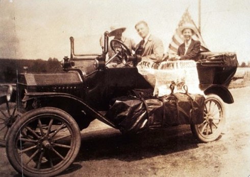
Well, today is Women’s Equality Day, designated in 1971 to commemorate the 1920 passage of the 19th Amendment to the Constitution, which finally granted women the right to vote after a long struggle for suffrage. I’m embarrassed to admit that I never knew this was a “day”, but it seems as good a time as any to shine a spotlight on a Salem suffragist (I’m an English historian, so I used my preferred “Suffragette” in the title, but the more appropriate American term is “Suffragist”). I’m certain that there was more than one fierce advocate of votes for women in progressive Salem, but Margery Bedinger of Forrester Street committed at a crucial time, and went on to lead a very interesting and independent life. And I have pictures! Margery was born in Salem in 1891, the daughter of the Rector of St. Peter’s Church (and the granddaughter of the Ambassador to Denmark). She matriculated at Smith College first, but graduated from Radcliffe in 1913. In 1914 and 1915, she was one of many members of the Massachusetts Woman Suffrage Association campaigning actively in support of a state referendum to give women the right to vote. The suffragists and their supporters walked, ran, trolleyed, biked and drove all around the Commonwealth, distributing their colorful materials and holding open-air forums, and capped off their campaign with of parade of 9000 supporters (including Helen Keller) on October 16. Despite their efforts, the referendum failed, and Massachusetts women did not gain the vote until the 19th amendment was ratified in 1920. Margery was no doubt disappointed by the returns of 1915, but she moved steadfastly forward (and west–where suffrage had triumphed first), completing her graduate degree in Library Science and becoming the first female librarian at the United States Military Academy at West Point in the 1920s (and later publishing a “spirited” article about the Academy entitled “The Goose Step at West Point” in the New Republic), assuming a succession of library directorships at academic libraries in Montana, Washington, and New Mexico, authoring an authoritative book on Native American jewelry, traveling the world, and finally retiring to Hawaii!

Margery Bedinger was an incredibly accomplished woman but I only discovered her through another incredibly accomplished woman: Florence Hope Luscomb (1887-1985), the leader of the Massachusetts Suffrage movement and one of the first women to graduate from the distinguished architectural program at the Massachusetts Institute of Technology (this was just the beginning of a long lifetime of social and political activism). Luscomb’s papers are at the Schlesinger Library at Harvard University, and while I was looking around for things related to her architectural practice, I found Margery, her comrade in 1915. And here is Margery at work and at play, in those interesting times a century ago.

MB6

MB 5

MB2

MB4

MB3

Margery Bedinger of Salem (front and center) and her Massachusetts suffragist colleagues on their “auto tour” across the state, 1915, & Margery and her horse somewhere out west a bit later and in close-up, from the Florence Hope Luscomb Archive at the Schlesinger Library, Radcliffe Institute for Advanced Study, Harvard University. Below: a broadside and paraphernalia from the 1915 campaign–the back of the fan reads “keep cool and raise a breeze for suffrage”.

Suffrage Broadside 1915 MHS

Suffrage mementos MA


De Facto Demolition

One year ago contractors working for a developer/convenience and liquor store owner named Jewel Saeed tore the roof off a Federal house on Carlton Street here in Salem and exposed it to the deluge of an approaching tropical storm: in the following weeks they ripped out all of the original (soaked) fabric, including its massive center chimney, and rebuilt it as petrochemical-clad condominiums, surrounded by blacktop. I may rant against the huge generic buildings which are gradually transforming the Salem streetscape, but no Salem development has ever troubled me more than the mutilation of 25 Carlton Street. The act was so brazen, and the response so tepid. Carlton Street is not located in one of Salem’s four historic districts, so it is not subject to overview by the Historic Commission, but all Salem structures are subject to the city-wide Demolition Delay Ordinance and Mr. Saeed did not apply for a demolition permit or a waiver. He didn’t have to bother. But make no mistake: the structure that now occupies the lot designated 25 Carlton Street is not the same building that existed a year ago.

Carlton Street 1985

Carlton Street 2014

drowned-house-014


Carlton Street 003p

Carlton Two 007

Carlton Street 010

25 Carlton Street in 1985, 2014, and this (very foggy) morning. The fine grain of vinyl siding.


A Kingdom for a Horse

This is the time of year that every teacher, at every level, is in a back-to-school mentality. I don’t feel like I’ve been out of school this particular summer, but nevertheless I am preparing for my fall classes with that usual sense of expectation–thank goodness. I haven’t taught a graduate course for a while, and this semester I’ll be teaching one of my favorites, a readings course on early modern England. I see some great students on my roster, I’ve chosen some of my favorite books old and new, and I expect that the entire experience will be a welcome weekly escape from my daily chair duties. For those of you who are not familiar with European historiography and chronology (which generally, with some variations and accommodations, incorporates English historiography and chronology), the early modern era begins around the turn of the sixteenth century, which means that early modern England begins with the Tudor Dynasty. And the Tudor Dynasty began today, 530 years ago, when Henry Tudor, the Earl of Richmond and last Lancastrian standing, defeated King Richard III and his force at the Battle of Bosworth. Richard was killed in the battle (the last English king killed in action) and Henry was crowned shortly thereafter, right on the field.

Richmond crowned after the battle of Bosworth Field. Illustration from History of England by Henry Tyrrell (c 1860).

A rather romanticized Victorian view of the crowning of Henry over Richard’s dead body, from Henry Tyrell, A History of England for the Young (1860)

I don’t like to consign history to big battles but this was a big battle, a definite turning point. And even though Richard’s reputation has been somewhat restored by the recovery of his body from under a Leicester parking lot in 2012 (revealing 10 wounds to his head sustained during the battle) and its ceremonial re-internment this past spring, I doubt that he can ever rise above the characterization bequeathed to him by Shakespeare in his Tragedy of King Richard the Third, written in the last decade of the reign of Elizabeth I and the Tudor dynasty. While watching the dignified re-internment ceremony (featuring Benedict Cumberbatch–apparently a distant relation), I couldn’t help but think: all this for a ruthless child murder? On the other hand, the physical deformity which represented the rot within for Shakespeare only made him seem more human–and therefore vulnerable–when his skeleton was revealed. In any case, one Bosworth anecdotal episode that’s never going to go away, even though it is Shakespeare History rather than History, are his last moments and words, when, unhorsed, his character cries out in frustration: A Horse! A Horse! My kingdom for a Horse! These words are enduring because they are so Shakespearean universal: I’ve got ALL this but I really need THIS. Even the very biased Bard was willing to give the last medieval English king a bit of humanity/vulnerability at his/the very end.

Bosworth Garrick BM

Bosworth Garrick BM2

Bosworth Garrick VA

Bosworth Forrest LC

Bosworth Jefferson Davis 1864

Bosworth Yost LC

my_kingdom_for_a_horse_by_georgegoodnight-d4dwzj3

The fame garnered by David Garrick (1717-1779–buried right next to Shakespeare in Westminster Abbey) in the role inspired many representations of Richard giving his “horse” speech: here are late 18th and early 19th century prints from the collections of the British Museum and Victoria & Albert Museum; the prominent American Shakespearean actor Edwin Forrest in the role as depicted in an 1855 print, Library of Congress; obviously such drama inspired satire, as seen in the Lincoln Campaign Dial for November 1864 (available here) portraying Jefferson Davis as Richard III and in George Yost Coffin’s political cartoon from the 1890s, Library of Congress; a neat photomanipulation by George Goodnight, aptly titled “My Kingdom for a Horse”.


The Reverend Billy Cook, Salem’s Self-Published Poet

As I am typing this, beside me is a little hand-bound and -printed pamphlet of verse, what one might call a chapbook, dating from 1852: it is one of many similar publications produced by the Reverend William “Billy” Cook (1807-1876) in the middle of the nineteenth century and sold to family and friends. The son of a prosperous ship captain, Cook spent his entire life in Salem except for stints at Phillips Academy in Andover and Yale University, from which he failed to graduate because of illness–both physical (typhus) and mental: his sole biographer, Lawrence Jenkins, writes in 1924 that “unkind Nature” had failed to outfit this “gentle soul” with a “complete and well-balanced headpiece”.  After his return to Salem, Cook studied for the ministry but never made it beyond the level of Deacon: nevertheless he and everyone else seems to have referred to him as “Reverend”. To make ends meet (as the captain’s money seems to have run out), Cook tutored private students in Latin, Greek and mathematics and began writing and sketching. He maintained what is referred to as an “art gallery” in his home on Charter Street and included woodblock illustrations in all of his publications. These woodblocks are quite primitive, nevertheless they highlight the fact that Salem was Cook’s entire world as numerous street scenes and buildings are intermingled among his verse whether they have anything to do with Salem or not. According to Jenkins, the woodblocks were carved from maple or birch wood by Cook with a jack-knife, and touched up with lead pencil or paint after they were printed–one page at a time–on a hand-press that he had built himself. This rather rudimentary process is revealed by the folk nature of the prints, but I think it also renders them a bit more timeless, and charming.

Cook Ploughboy Prints

Cook Ploughboy's Harrow

Cook East Church

Cook First Baptist Church Print

Cook St. Peters Church

Cook Tollhouse Print

Cook Pickering House Print

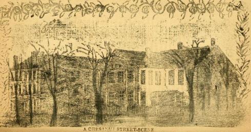
I wish I knew more about William Cook. Jenkins’ article definitely paints him as a rather eccentric figure, but isn’t he in a similar situation as his contemporary Nathaniel Hawthorne? The old Salem money had run out for both of them, and they had to depend on the their well-placed friends and ink-stained hands to provide for themselves. And they were both so so shaped by Salem. (I think the similarities must end here). The poem that illustrates Cook’s life the best for me is his “Chestnut Street”: not only did he include the names of all the contemporary residents of the street but also accompanying illustrations of nearly every building by my estimation (including the McIntire South Church). He had to: these were his patrons. So here we have quite a different Chestnut Street than that portrayed later in the photographs of Frank Cousins or the etchings of Samuel Chamberlain. Cook’s style emphasized the elemental fundamentals–chimneys and windows–and all those top-heavy, twisting trees–the lost elms of Chestnut Street, I believe.

Cook Chestnut Scene

Cook Chestnut Scene 2

Cook Chestnut Street 5

Cook Chestnut Scene 7

Cook Chestnut Scene 8

All illustrations from The Euclea collection of Cook’s poetry, 1852;  For more on Cook see the only source: Lawrence Jenkins, William Cook of Salem, Mass.: Preacher, Poet, Artist and Publisher,” in the Proceedings of the American Antiquarian Society, New Series, Vol. 34, April 9, 1924-October 15, 1924.


Old Homes Made New 1879

After I came across a little book named Old Homes made New. Being a Collection of Plans, Exterior and Interior Views, Illustrating the Alteration and Remodeling of Several Suburban Residences, published in 1879 by architect William M. Woollett, I really understand the “alterations” made to my 1827 house by its owners in the later nineteenth century. Like the simple colonial and Greek Revival houses used as Woollett’s “befores”, my own house must have been far too spare for the exuberant sensibilities of my Victorian predecessors, and so they added bay windows, French doors, arches, etched glass, a curved mahogany banister, and lots more space–up and out they went, into the attic and out back: I guess I should be thankful I don’t have a tower or a turret! The 1920s owners of the house attempted to restrain the house’s exuberance under their stewardship, but I bet they liked the light provided by the bay windows and I know they needed the space: they had 12 children!  And so what remains is an amalgamation, just like Stonehurst, and most houses, I suppose.

oldhomesmadenew cover

oldhomesmadenew8

Old Homes made New 1812

oldhomesmadenew 1812 remodeled

oldhomesmadenew

oldhomesmadenew 4

oldhomesmadenew 5

oldhomesmadenew modernized hallway

“Modern” houses, a modernized hallway, and a modern man from William Woollett’s Old Homes Made New (1879).


Stonehurst

Waltham, Massachusetts is a bustling little city just west of Boston that manages to be urban, suburban, and rural all at the same time, depending on what sector you find yourself in. There’s a lot there: an impressive industrial heritage, two universities, Bentley and Brandeis (where I got my Ph.D.), a pretty vibrant downtown, lots of corporations along the Route 128 beltway, and three historic “country” estates preserved as house museums: the Lyman Estate (also known as “The Vale”, built in 1793 and owned and operated by Historic New England), Gore Place (built in 1806 and saved in the 1930s by the Gore Place Society), and Stonehurst (completed by 1886 and owned and operated by the City of Waltham since 1974). Because of my predilection for early American architecture, I have visited the older houses many times: Samuel McIntire designed the foundation structure of The Vale and Gore Place is just about the most elegant Federal house anywhere (outside of Salem, of course). But despite the fact that it is the product of a collaboration between two giants of late nineteeth-century design, architect Henry Hobson Richardson (1838-1886) and landscape architect Frederick Law Olmsted (1822-1903), I have to admit I have dissed Stonehurst: I saw it long ago and never returned. The other day I was driving home along Route 128 at just the wrong time on a beautiful day: it was rush hour(s) and the northern lanes were jam-packed. I just had to get out of the car, and as I happened to be in Waltham, I thought I’d go look at the Lyman Estate for a bit and wait out the traffic. After I turned off the highway, however, I saw the sign for Stonehurst and remembered that it is situated on far more land: 109 acres of Olmsted-designed walking trails, to be precise–and I needed some exercise. So there I went, but got slightly distracted by the house, which is a bit……………intimidating? perplexing? provocative?

Stonehurst 002

Stonehurst 005

Stonehurst 018

Stonehurst 023

Stonehurst 010

Stonehurst 060

Stonehurst is really a combination of two houses built for Robert Treat Paine, a Boston lawyer, philanthropist, and advocate for workers’ housing (scion of a real Brahmin family: his namesake grandfather was a signer of the Declaration of Independence and Massachusetts’ first Attorney General) and his wife Lydia Lyman Paine: her father had financed the Second Empire house that constitutes the western end of the structure, which was later deemed too small for their large family. So Paine (who served on the building committee which oversaw Richardson’s masterpiece, Trinity Church in Boston) commissioned the architect to relocate the house and integrate it with a structure of his own design. The exterior (again, to my untrained eye!) is therefore quite an amalgamation: of the pre-existing Second Empire house, combined with Richardson’s more organic “Richardsonian Romanesque” and Shingle styles. I found the interior far more integrated, with large rooms that related to one another (and the outdoors) in a very pleasing way, and lots of crafted built-in features: window seats, benches, bookcases, mantles, staircases, mouldings: a warm and inviting Arts and Crafts house encased in a somewhat more imposing envelope.

Stonehurst 026

Stonehurst 032

Stonehurst 029

Stonehurst 036

Stonehurst 038

Stonehurst 056

Stonehurst 039

Stonehurst 050

Stonehurst 051

Stonehurst 046

Stonehurst 061

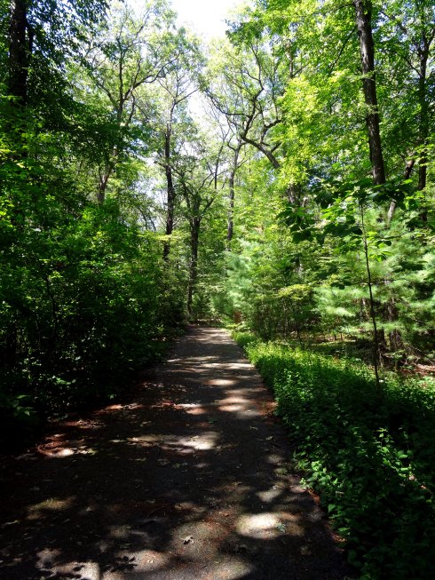
Interior of Stonehurst and a trail not taken; the line inscribed on the second-floor landing mantle, “Build Thee More Stately Mansions, O My Soul” is from the Oliver Wendell Holmes poem, The Chambered Nautilus.


Fleeting Phlox

I’m going take a break from berating ugly buildings and stop and smell the….phlox, because it’s that time of year, or maybe even past time. My garden is shaded quite a bit by Hamilton Hall next door so my bright white “David” phlox is in full bloom, but I took a walk around the beautiful gardens of Glen Magna Farms in Danvers yesterday afternoon and saw that their multiple varieties were on their way out. Still lovely, though. I always think of phlox as the ultimate country New England perennial–in Vermont and Maine and western Massachusetts you see it everywhere adjacent to old houses but less so in the old seaports like Salem. It’s a North American native that became so beloved in England in the later nineteenth century that English botanists created unique varieties that they then sold back to American gardeners, who were desirous of colorful versions of “antique” flowers for their Colonial Revival gardens. When I was planting my own garden, I just wanted a mildew-resistant variety, so I went with “David”, but the phlox in all shades of pink at Glen Magna have made me a bit envious. The source for all varieties of phlox is Perennial Pleasures up in northern Vermont, and their annual Phlox Festival is on right now, so if you have the time and the inclination this weekend by all means go—it’s well worth the trip, believe me.

My small patch of phlox, and the more lavish display at Glen Magna Farms, set against the McIntire main and summer houses:

Phlox 076

Phlox 034


Phlox 029

Phlox 061

Phlox 058

Phlox 055

Phlox 039

Phlox in its heyday: adopted by English illustrators, artists, and horticulturists: Frederick William Hulme (1816-1884; Victoria & Albert Museum), Bertha Newcomb (1895, Southwark Art Collection), and a seed packet from the 1930s (Victoria & Albert Museum).

Phlox Hulme VA 19th century

Phlox Seed Packet V and A 1930s

Can you find the phlox in the pioneering Cubist painting by the French artist Albert Gleizes, La Femme aux Phlox (1910, Museum of Fine Arts, Houston)?

800px-Albert_Gleizes,_1910,_Femme_aux_Phlox,_oil_on_canvas,_81_x_100_cm,_exhibited_Armory_Show,_New_York,_1913,_The_Museum_of_Fine_Arts,_Houston.


From Corner Store to Colossus

There are no pretty pictures in today’s post (well, as usual, the historic one is relatively pleasing) but I feel the need to weigh in on yet another inappropriate development looming over Salem–in this case, threatening the view and the neighborhood I see from my office window at Salem State University. An assortment of tired twentieth-century shops grafted onto an older building in a rather awkward–but certainly not imposing–manner might possibly be replaced by a behemoth commercial structure more appropriate for a Route 128 office park, and if the developer doesn’t get this way, an apparently even larger building comprising 34 residential units. The developer in question is of course from nearby Marblehead, a town which has produced a long line of investors in Salem, hoping to either reap returns or assuage their suburban guilt over residing in a town that “celebrates diversity” but has none. He unabashedly proclaims his project “Lafayette Place” even though there is a lovely little street bearing the same name (for over a century) a few blocks down the road. Because he is also a former overseer of SSU, there are also concerns that this is another encroachment by the university into a residential neighborhood. I really hope that’s not the case and I tend to think it is not: the university is building big–very big–on its own campus but it is also the new tenant of an ambitious adaptive reuse project just down the road from the proposed “Lafayette Place” (and up the road from the real Lafayette Place) in which a Salem developer has transformed the former Temple Shalom into an academic building within its existing footprint.

Now brace yourself for the pictures: the corner of Lafayette and West Streets, present, past, future (?). The cute little A&P store that once occupied the site (you can still see its Colonial Revival “frame”) makes me very sentimental for corner grocery stores in general and A&Ps in particular, although I’m not sure I’ve even been in one! The scale of this building is still appropriate for its surrounding neighborhood.

Corner Store 002

Corner Store 005

Corner Store AP SSU

Corner Store Lafayette Place

Lafayette Place 2

The corner of Lafayette and West Streets present & past (Dionne Collection, SSU Archives and Special Collections), and renderings of the proposed “Lafayette Place”.  Jerome Curley, a great source for Salem’s visual history and history in general, has offered the picture below so you can appreciate the scale issue. On the immediate right is the Lafeyette/West corner, and all of those residential buildings on both sides of the street remain. (From his Salem through Time, co-edited with Nelson Dionne).

Lafayette West Corner